Download

1 / 14
140 likes | 282 Views
Explore the basics of latitude and longitude coordinates, defining parallels and meridians, and understanding time zones on Earth. Discover how to determine positions using degrees, minutes, and seconds with reference to the Equator, Prime Meridian, and the North Star. Learn how longitude is tied to timekeeping and how time zones affect global time synchronization. Delve into the concept of solar time and the rotation of the Earth, and witness the transition from day to night in different parts of the world.

E N D
Latitude and longitude • Measured in degrees, minutes, seconds • 1 degree = 60 minutes (1° = 60’) • 1 minute = 60 seconds (1’ = 60’’) Nautical mile (nm) • 1 nm = 1’ of arc length of latitude • 1 nm = 1’ of arc length of longitude at the equator
Latitude and longitude Latitudes (or parallels) are parallel to the equator • 0 to +90° Northern Hemisphere • 0 to -90° Southern Hemisphere • Small circles Longitudes (or meridians) are formed at right angles to the latitude lines • Measured from the Prime Meridian • 0 to 360° East from the Prime meridian • Or, 0 to +180°E and 0 to -180°W • International date line • Great circles
North Pole 60°N 30°N Latitude 0° Equator 30°S South Pole Latitude
North Pole Reference: Prime meridian Longitude 60°W 0° at Greenwich South Pole Determining Longitudes
Longitude and time • Use of clocks to record the time the Sun is at its zenith • Greenwich Mean Time (GMT) or Universal Time • Earth rotates 15° of longitude each hour http://www.rmg.co.uk/harrison
http://www.bbc.co.uk/news/world-13334229 (Samoa changes time zone)
East Increase – West Less(1 hr per l5°) If it 9 p.m. at Position D, what time is it at position C? Position B? If it is 1 p.m. at Position X, at which location is the time 5 p.m.
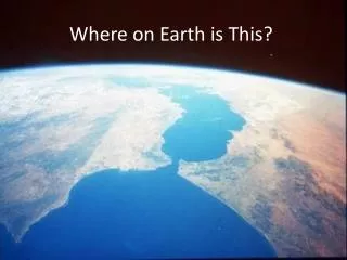
Earth rotates west to east Solar time is based on the position of the sunNIGHT IS FALLING ON EARTH • Look at the East Coast of the United States. The lights are already lit. • California the sun is still visible.