Download
1 / 19
190 likes | 283 Views
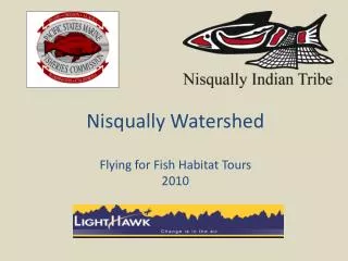
Hood Canal Jefferson County Flying for Fish Habitat Tours December 2007. The Flying for Fish Habitat flight program.

E N D
Hood Canal Jefferson County Flying for Fish Habitat Tours December 2007
The Flying for Fish Habitat flight program Pacific States Marine Fisheries Commission with support from LightHawk has been providing educational aerial tours throughout Puget Sound for over a decade to help officials and community leaders better understand and protect watershed habitat. In 2007 PSMFC partnered with Hood Canal Coordinating Council to provide flights over the Hood Canal in Jefferson County. Pam Goddard
The Hood Canal Coordinating Council is a Watershed-Based Council of Governments. • It was established in 1985 in response to community concerns about water quality problems and related natural resource issues in the watershed. • HCCC is currently responsible for coordinating salmon recovery and the Hood Canal Aquatic Rehabilitation Program. • The HCCC includes three counties that boarder Hood Canal; Jefferson, Kitsap, and Mason.
Welcome to the Jefferson County Hood Canal Watershed Tour • Hood Canal is a 60 mile long fjord with over 200 miles of shoreline and estuaries fed by large river systems. • Hood Canal supports several species of threatened salmon including a unique summer chum salmon, Chinook salmon and bull trout. • The Hood Canal Area is a priority for salmon recovery as identified in the Salmon Plan. • This aerial survey provides a unique perspective of how human activities can impact salmon habitat in Hood Canal. The focus of this flight tour is the northwest area of Hood Canal within Jefferson County. Washington State Department of Ecology, Shoreline Aerial Photos
Flight Path 1 Lower Discovery Bay Estuary Restoration 2 Proposed Master Planned Resort at Black Point over to the Dosewallips and up that watershed. 3 Quilcene River and Quilcene Bay estuary 4 Tarboo/Dabob Bay area. 5 Proposed FHM pit-to-pier site. 6 Working forest lands along the SR104 corridor. 7 Port Ludlow area. 8 Chimacum Creek. 1 8 7 6 4 3 5 2 Eric Fogelin, LightHawk
Pleasant Harbor/Black Point Washington State Department of Ecology, Shoreline Aerial Photos Nearshore habitat is important to salmon. Planning guidelines can be implemented to help place development so that impacts are minimized.
Lower Dosewallips Richard Brocksmith, HCCC The Dosewallips River is the second largest tributary watershed to the Hood Canal and important to salmon. Coordinated habitat restoration projects are underway here.
Middle Dosewallips Richard Brocksmith, HCCC Salmon thrive in complex river systems that offer protection, spawning gravel (redds), and food sources. When rivers are channeled salmon habitat is lost.
Upper Dosewallips Richard Brocksmith, HCCC The upper reach provides pristine salmon habitat. Efforts to increase public access to these areas need to consider the impacts they present.
Quilcene River & Quilcene Bay Washington State Department of Ecology, Shoreline Aerial Photos Hood Canal shorelines include large estuaries, moderate sloped beaches and abundant eelgrass beds important for support of juvenile salmonids.
Tarboo/Dabob Bay Washington State Department of Ecology, Shoreline Aerial Photos Tarboo-Dabob Bay is one of the largest examples of a saltmarsh estuary and marine riparian shoreline remaining in Puget Sound. Collaborative efforts continue to extend preservation of this important and pristine salmon habitat.
Working Forest Land Richard Brocksmith, HCCC Protecting working forest lands can protect salmon habitat.
Port Ludlow Washington State Department of Ecology, Shoreline Aerial Photos Preservation and restoration of habitat as well as carefully planed, salmon habitat sensitive approach to development, is critical for the future survival of salmon, marine wildlife, and quality of life in the Hood Canal.
Chimacum Creek Jefferson County Natural Resources The lower main stem and estuary of Chimacum Creek are important to salmon. Support for a combination of preservation and restoration efforts and the implementation of salmon friendly land use practices will protect salmon here and elsewhere in Hood Canal.
LightHawk provides aerial support for all Flying for Fish Habitat tours. • Champions environmental protection through the unique perspective of flight. • The view from above speaks for itself, providing breathtaking clarity of understanding.
PSMFC’s Fish Habitat Education Program offers educational aerial and ground watershed tours. • For ten years, this project has provided hundreds of participants with a vivid experience of local watersheds as well as a means to connect with people, resources, and information. • It strives to translate awareness into action on behalf of fish habitat.
Partnering with Flying For Fish Habitat Program • Contact Mandy Merklein or Pam Goddard if you would like to partner with Flying for Fish Habitat. 5415 NE 54th Street Seattle, WA 98105 206.786.8245 mandybruce@co-eco.com p.goddard@thalassaconsulting.com Virtual flight tour on web at http://www.psmfc.org/habitat/virtual/
Sources • Hood Canal Coordinating Council web page (http://www.hccc.wa.gov) • Department of Ecology – Shoreline Aerial Photos (http://apps.ecy.wa.gov/shorephotos/) • Shared Strategy for Puget Sound – (http://www.sharedsalmonstrategy.org) • LightHawk (http://www.lighthawk.org) • PSMFC (http://www.psmfc.org/habitat/) • Peninsual Daily News (http://www.peninsuladailynews.com/article/20071220/NEWS/712200305) • Jefferson County Department of Natural Resources (http://www.co.jefferson.wa.us/naturalresources/ChimacumCreekPark.asp)
Please Share Your Experiences • This aerial watershed tour has been a collaborative effort between our groups. Only a few individuals can actually fly. • We hope you will join us in sharing your experiences with others. This PowerPoint show is available at www.psmfc.org/habitat/virtual. • Working together we can prioritize tasks and accomplish good things for our fish, our communities, and our economies.