Geospatial Data Collaborative Efforts for Environmental Research & Development
Explore the extensive database encompassing billions of LIDAR returns from various institutions and agencies, covering 85,757 km2. The collaborative efforts of NSF, USGS, and other partners bring cutting-edge geospatial data for research. Access over 108 datasets and growing, providing vital information for environmental studies. Discover how this resource has been leveraged by a diverse user base, including students and researchers worldwide.

Geospatial Data Collaborative Efforts for Environmental Research & Development
E N D
Presentation Transcript
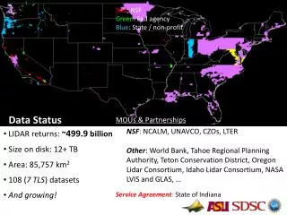
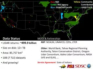
Red: NSF Yellow: Community Green: Fed agency Contributed Blue: State/non-profit Green: USGS CLICK Data Status • LIDAR returns: ~499.9 billion • Size on disk: 12+ TB • Area: 85,757 km2 • 108 (7 TLS) datasets • And growing! 13078.02 MOUs & Partnerships NSF: NCALM, UNAVCO, CZOs, LTER Other: World Bank, Tahoe Regional Planning Authority, Teton Conservation District, Oregon Lidar Consortium, Idaho Lidar Consortium, NASA LVIS and GLAS, … Service Agreement: State of Indiana
OT Data Ingestion by Quarter Data Status • NCALM Data: • Inc. EarthScope, CZOs, seeds, etc. • Total NCALM datasets: 108 (+ 17 under embargo & 2 planned for this year) • NCALM on OT: 67 • ~75% of NCALM data available via OT • More coming monthly
Usage Metrics: users & data access • Statistics • 17,790 Pt. Cloud Jobs • 447 billion pts processed • 72,212 DEMs downloaded • ~2,500 registered users • 232 “power” users May 2010 May 2012
Users Demographics • Growing & diverse user base • ~56k unique visitors (past 12 months) • Top users are students (15 of top 25) • International reach