Download
1 / 12
120 likes | 246 Views
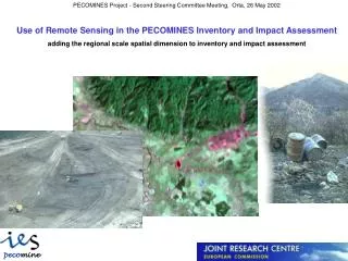
Use of Remote Sensing in the PECOMINES Inventory and Impact Assessment adding the regional scale spatial dimension to inventory and impact assessment. Expected Deliverables.

E N D
Use of Remote Sensing in the PECOMINES Inventory and Impact Assessment adding the regional scale spatial dimension to inventory and impact assessment
Expected Deliverables • Provision of methodology and demonstration of processing chain for fully geo-referenced identification and mapping of superficial mining waste deposits at local and national scale, based on spectral discrimination of key mineralogical components. • Process time series of Landsat TM satellite data to derive vegetation and land cover anomalies, as well as change detection on selected “hot spot” sites. • Spatial and multi-temporal analysis of observed anomalies and changes in relation to existing ground data (e.g. pH maps, water quality etc.) for impact assessment.
Specific Objective of Remote Sensing Support compilation of the inventory of waste sites from mineral mining in Pre-Accession countries in relation to “sensitive” catchment areas by improving spatial detail and differentiation of potentially hazardous mining waste material from other extraction sites and land fills in the CORINE LC reference system Summary of Inventory Approach The PECOMINES inventory combines site specific information coming from existing data bases in the candidate countries, which is harmonised through the PECOMINES questionnaire and put into a relational data base, with geo-referenced spatial information on the distribution and extension of waste material being mainly derived from remote sensing data. This information is linked to relevant standardised spatial data layers such as CORINE Land Cover, thus adding the spatial dimension to the inventory of mining waste at regional scale.
Achievements: • Identification of sites which are characterised by anomalous concentrations of both ferro-oxi-hydroxides (Fe-ox) and secondary clay minerals (OH-CL) by applying selective principal component analysis (PCA) to Landsat-TM reflectance channels. Co-occurrence of both types of anomaly is significantly indicative for most cases of waste material from metal mining or ore processing but also for other types of mineral deposits (e.g. lignite) where pyritic material is frequently associated leading to acidification. • Demonstration and evaluation of the application of PCA method to Landsat-TM data for rapid screening and spectral differentiation of mining waste deposits over large areas of Slovakia as well as Northern and Western Romania (total area covered in the test approximately 120000 km2). • fully geo-referenced mapping of accumulations of potentially hazardous mining related waste material on active and ancient quarries, waste dumps and processing plants for the regional coverage at scale 1: 50000 (50 m accuracy, > 1 ha object resolution) for improved differentiation of mining wastes from other extraction sites and land fills in the CORINE LC reference system
Landsat-TM scenes and areas mapped as mineral extraction sites and dump sites in the CORINE LC database
OH Fe Novoveska Huta – Rudnany (Slovakia) Landsat-TM image (07.10.1991) Map of mineral fuels and metals Processed image showing the zones with iron oxides and OH-bearing minerals
OH Fe BANSKA STIAVNICA (SLOVAKIA) Landsat-TM image (24.10.1989) Map of mineral fuels and metals Processed image
Conclusions (1) • The PCA method has been successfully tested and applied on large areas of Slovakia and of Northern and Western Romania (total area covered in the test approximately 120000 km2). • The reliability of the results has been demonstrated and validated against the site specific information of 3 areas in Slovakia and on 4 environmental “hot spots” in Romania provided by the Romanian partners. • Overlaying the results of the remote sensing anomaly screening with the vector information from CORINE highlights the potential to add significant value to CORINE LC in terms of spatial resolution and better differentiation of mining waste sites.
Conclusions (2) • Thus a standardised frame of spatial reference regarding mining waste issues throughout Europe could be realistically established, being from the beginning compatible with other spatial reference data layers used by the European Commission and the EEA • Since the EU-EEA IMAGE 2000 project, in preparation of the CORINE 2000 project, is currently preparing a geo-referenced mosaic of Landsat-TM data, covering the entire area of the EU and of the candidate countries, an operational application of the approach to the entire region would not be an unrealistic option