Download
1 / 19
190 likes | 236 Views
Tracing the development timeline of the SOSI standard from its inception in 1977 to the latest version. Learn about the project milestones, revisions, and the role of SOSI in standardizing geographic data.

E N D
The progress of SOSI 1977 - SOSI - project under the ministry of environment 1978 - First proposal of development of a transfer-standard 1982 - Workshops and discussions 1985 - First version of the formal syntax and formalism. 1987 - First complete version- SOSI version 1.0 1989 - FGIS project 1990 - First major revision of SOSI - version 1.4 1991 - First version including a feature-catalogue, version 2.0. 1994 - Revision - version 2.1. Includes more data-descriptions, also for scale 1:5000 1995 - Revision - version 2.2. 1996 - Revision - version 2.21 1998 - Revision - version 3.0 1999 - Revision - version 3.1 (STANDARD 2000)
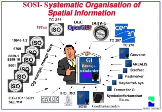
Mandate • The mandate of the SOSI-standardizing is standardizing within the area of Geographic Information. • The goal of this work is to establish one or more standards for geographic information regarding objects or phenomena's positioned relative to the surface of the earth. • This standards may specify methods, tools and services for data-managment (Including definitions and descriptions), processing, analysing, access, portrayal and transfer of such data in digital / electronic form, between users, systems and geographic areas. This work will be harmonised with standards for information-technology and data were appropriate, and a framework for sector-specific applications using such data must be established. • This work must be developed in close relationship to international standardisation and the rules and models developed there, especially CEN/TC 287 and ISO/TC 211.
Secretariates main responsibility • Participation at international/national standardization • Assist the WG’s within their application domains • Message-service (error-reports, new requirements, etc) • Internal/external information about the standards • Ensure that further developm. aligns with national strategies • Conformance and testing • Attract national environments to be involved
SOSI - organisation Planning Technics and models Terrain and control points Location names Coast and water Utility Transport Municipality Nature/rescource/ heritage
Structure of SOSI SOSI-SECRETARIATET Quality-control Quality-control part1 part2 part5 part4 Data- registration- instruction part3 SOSI-WG1 Introduction, notation, formalism practical usage Appendix- List of thematic codes, attributes and their domain- values. SOSI-WG’s 3-9 Feature- catalogue Aggregated/ generalised datadescriptions (K3) (K176) (FKB)
Feature catalogue (37 application domains) GFYS Geophysical mapping GVERN Geological conservation areas GROT Cave mapping (speleologi) REIN Reindeer management NATR Natural resources, wildlife, etc AREAL Other land use BYGG Buldings, constructions FORN Archaeological and architectural monuments and sites and cultural environments VBAS Road data VSIT Road situation BANE Railway SAMF General transport ADR Adresses LUFT Airport LEDN Utility NAVN Location names PLAN Planning PROSJ Projecting INNL Introduction FM Surevy Control Stations TERR Terrain KYST Coast and sea (S57) VANN Inland sea, rivers FISK Fishery OLJE Oil DEK Land property SERV Land restrictions / easements ABAS Administrativ and statistic areas DMK Land types LREG Agricultural Property Register JREG Land inventory DJD Soil-data GEOI Introduction - geology RAAST Mineral resources BERG Bedrock geology LOESM Surficial deposits GKJEM Geochemical mapping
Harmonisation of standards Framework Product spesification Data aquisition Productiion / cooperation Contracts Calibration certification/qualifications Basic- components Feature catalogue Description of geographic features Administrative guidelines within application domains Interfaces Presentations/ symbols Technologi
SOSI-3.1 Content: • SOSI-standard as HTML • SOSI-standarden as PDF • SOSIVIS - SOSI-browser • KVAKK - Quality control program • Search - Alta Vista Free text search
SOSI Medium Version Date Paper Computer readable (nr of pages) Text SOSI_db 1.0 87/10 112 No No 1.2 88/05 120 No No 1.3 89/06 137 No No 1.4 90/03 135 No No 2.0 92/03 335 No No 2.1 94/01 833 No No Yes 2.2 95/06 N/A No SOSI distribution Yes 3.0 97/12 1319 No 99/11 Yes Yes 3.1 Nei
New model for standardization management SOSI-Part 2 SOSI-template Clause 1 Clause 2 Clause 3 Clause 4 Clause 6.3 Clause 6.4 ACCESS -base Part2 (partly) Generated automatic Clause 5 Clause 6.1 Clause 6.2 manuel HTML-conversion Thema- code Attribute- list Fase 2 ??? Parameter -files SOSI- ver. ?.? KVAKK
ACCESS -base SOSI- Feature Catalogue ISO/TC 211 Feature Catalogue Methodology ISO 19110 compliant Parameter -filer Theme- codes SOSI-attributes KVAKK
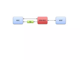
ACCESS -base Quality control of SOSI-files Styringsparametere fra brukeren SOSI-fil(er) Next step KVAKK Parameterfiler DEL1 DEL2 Loggfil SOSI-rapport Rapportfil
Access and distribution Policy And guidelines Standardsr Geodata Qualification and training Cooperation Future work K176 Governmental report ”Noreg digitalt” NGIS Strategy for impelementation of international standards (Standard 2000) ?