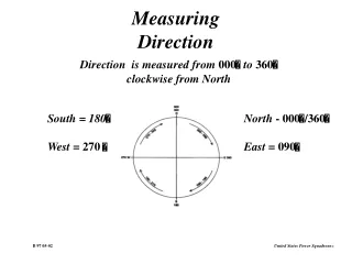
Flow Direction
Flow Direction. FE 423 - Lecture 4b. OUTLINE. The in-class midterm GRID HYDROLOGY Spatial Analyst vs. ArcGRID FlowDirection: water flows downhill Representing flow with Streamlines Filling sinks in dems. The in-class midterm. Total: 27 Mean: 17 Max: 24.5 Min: 13. Course Goals.

Flow Direction
E N D
Presentation Transcript
Flow Direction FE 423 - Lecture 4b
OUTLINE • The in-class midterm • GRID HYDROLOGY • Spatial Analyst vs. ArcGRID • FlowDirection: water flows downhill • Representing flow with Streamlines • Filling sinks in dems
The in-class midterm • Total: 27 • Mean: 17 • Max: 24.5 • Min: 13
Course Goals 1a. Data for each point in the watershed 1b. Calculate processes at each point 2a. Sum outputs from upslope area 2b. Sum ‘delivery costs’ to stream
Spatial Analyst vs. ArcGRID • Grid • Equations are easier to write • More functionality • Spatial Analyst • easier to view output • revising code
Flow Direction (hint: downhill) The steepest downhill gradient. ArcView: Hydro/FlowDirection Avenue: [dem].FlowDirection(ForceEdge)
STREAMLINES • Representing flow direction
FILLING SINKS • Sinks in demspoints lower than neighbors stop flow • Filling sinksHydro/Fill
Discussion Problems Revisit Practice Midterm with Zonal mean: ([value].ZonalStats(#GRID_STATYPE_MEAN, [zone], Prj.MakeNull, [zone].GetVTab.FindField("Value"), FALSE))
Discussion Problems Overlay streamlines and the stream cover on a hillshade of the HJ Andrews dem. Where does the network look wrong? Does filling the dem fixes the problem? Identify and quantify the changes that FILL made.
Discussion Problems Road-side ditches can impact watershed hydrology by intercepting surface and subsurface flow and rerouting to the stream. Make a modified flowdirection grid, in which roads intercept downslope flow and route it along the ditch to the streams. Use streamlines to verify that the water now flows the way it should.
If You Want Avenue Book • Call ESRI’s Bookstore number • Ask for ‘Using Avenue’ • To get discount, say you are UW student in UW course and UW is a license holder • Or go to UW Bookstore and get one of the Avenue books that they have (in geography)