Download
1 / 8
90 likes | 271 Views
Topographic Radar Beam Blockage and its Effects on Radar Rainfall Estimates: The BREAM Model. Timothy A. Coleman Atmospheric Science Department The University of Alabama in Huntsville. 1. Introduction.

E N D
Topographic Radar Beam Blockage and its Effects on Radar Rainfall Estimates: The BREAM Model Timothy A. Coleman Atmospheric Science Department The University of Alabama in Huntsville
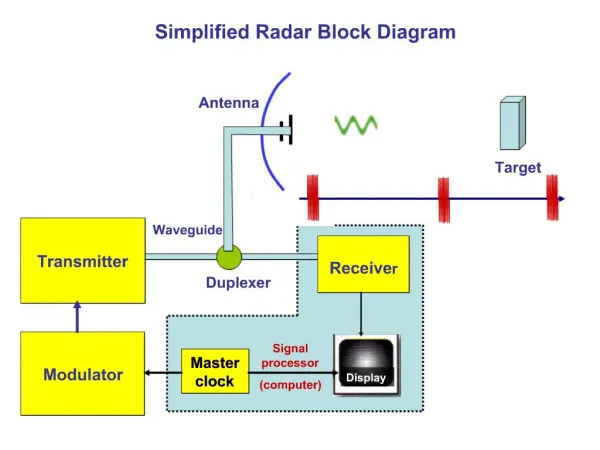
1. Introduction • Radar beam may be completely blocked by mountains, eliminating useful data beyond that range. • Radar beam may be partially blocked by terrain, introducing errors into all radar data beyond the blocking terrain feature. • Assumption is made that the radar beam loses transmitted, and thus returned power, proportional to the percentage area of the beam that is blocked. • Using GLOBE Digital Elevation Model Data, along with radar propagation equations, to estimate beam blockage at each point. • Similar to the approach by Kucera et al. (2004).
2. Radar beam propagation • Assuming standard refraction and earth curvature: (Rinehart 1997) • Also, for simplicity, assuming a uniform beam, and recognizing that the area of the beam blocked by terrain of height h is given by: H = (r2 + R’2 + 2rR’sinf)1/2 – R’ + Ho AB = a2arccos((a-h)/a) – (a-h) (a2-(a-h)2)1/2
4. Modeling topographic beam blocking - BREAM • GLOBE DEM terrain data after conversion to polar coordinates around BMX WSR-88D • Azimuth 15 degrees from WSR-88D at BMX, 46.3% of beam blocked beyond 20 km range, resulting in 2.7 dBZ reflectivity error
4. Modeling topographic beam blocking - BREAM BREAM model beam blocking (dB) by azimuthal direction Actual ground clutter observed at BMX radar. Note good agreement with BREAM model.
4. Modeling topographic beam blocking - BREAM • BREAM can also compute, by azimuth, the minimum beam elevation required for a radar to completely avoid beam blocking
5. Beam Blocking Effects – Light Rain Rain-gauge measurements superimposed on radar-estimated precip. Note that, despite heavier rain in Jefferson County, radar shows lighter rain.