Download
1 / 10
100 likes | 210 Views
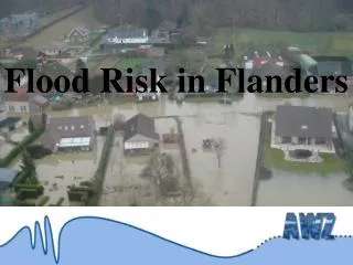
This analysis explores the maximal damage caused by flooding in Flanders across various sectors, including housing, industry, recreation, and agriculture. It details potential damages to buildings, vehicles, and infrastructure such as airports and roads. The research examines economic losses through polygons and points, mortality calculations, and differentiates between fresh and saltwater impacts. Methodological approaches adapted from Europe to the Flanders context will be discussed, addressing ongoing questions about spatial recording standards and legal uncertainties in flood risk management.

E N D
Maximal damage buildings furniture cars • Housing • Industry • Infrastructure • Airports • Recreation • Agriculture • Linear elements • Point elements • Forest • “Nature” • Water field crops, vegetables, … pasture roads railroads hospitals, mills, antennas, public buildings, …
Other research • Economic damage (polygons, lines, points) • Calculation of mortal victims • Differentiation between fresh and salt water
Some remarks: • folders with an explanation of the methodology used in Flanders available • what we do is not totally new, we adapt methodologies from everywhere in Europe to the Flanders situation • lots of questions are still open: • what’s a good spatial scale for recording a norm (standard)? • how to deal with uncertainty in legal norm en with evolution? • …