Download
1 / 16
160 likes | 330 Views
Chapter Outline 6.1 Introduction 6.2 Attribute Data in GIS 6.2.1 Organization of Attribute Data 6.2.2 Type of Attribute Data 6.3 The Relational Database Model 6.3.1 MUIR: An Example of Relational Database 6.3.2 Normalization 6.3.3 Type of Relationship

E N D
Chapter Outline 6.1 Introduction 6.2 Attribute Data in GIS 6.2.1 Organization of Attribute Data 6.2.2 Type of Attribute Data 6.3 The Relational Database Model 6.3.1 MUIR: An Example of Relational Database 6.3.2 Normalization 6.3.3 Type of Relationship 6.3.3.1 Example 1: Type of Relationship between Normalized Tables 6.3.3.2 Example 2: Type of Relationship in the MUIR Database 6.3.3.3 Type of Relationship and Data Display 6.3.4 Working with Attribute Data Management in GIS Box 6.1 Attribute Data Management Using ArcView Box 6.2 Attribute Data Management Using ArcInfo Workstation
6.4 Attribute Data Entry 6.4.1 Field Definition 6.4.2 Methods of Data Entry 6.5 Attribute Data Verification 6.6 Creating New Attribute Data from Existing Data 6.6.1 Attribute Data Classification 6.6.2 Attribute Data Computation
Applications: Attribute Data Entry and Management Task 1: Enter Attribute Data of a Geodatabase Feature Class Task 2: Enter Attribute Data of a Shapefile Task 3: Relate Tables in ArcMap Task 4: Join Tables in ArcMap Task 5: Create New Attribute by Data Classification Task 6: Use Advanced Method for Attribute Data Classification Task 7: Create New Attribute by Data Computation
Attribute data on the right are linked to spatial data by the label ID of map features.
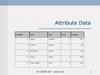
Row Column A feature attribute table consists of rows and columns. Each row represents a map feature, and each column represents a property or characteristic of the map feature.
PIN Owner Zoning P101 Wang Residential (1) P101 Chang Residential (1) P102 Smith Commercial (2) P102 Jones Commercial (2) P103 Costello Commercial (2) P104 Smith Residential (1) a. Flat File b. Hierarchical Zoning 1 2 P101 P104 P102 P103 Wang Chang Smith Smith Jones Costello Database design: (a) flat file, (b) hierarchical
Zoning Owner c. Network 1 2 Wang Chang Smith Jones Costello P101 P102 P103 P104 Zoning Owner d. Relational Zonecode PIN Parcel Database design: (c) network, and (d) relational.
SSarea Keys: state code, soil survey area ID Map Unit Keys: state code, soil survey area ID, map unit symbol Comp Keys: state code, soil survey area ID, map unit symbol, sequence number The three most important tables in the MUIR database. Ssarea is the soil survey area table, map unit is the soil survey map unit table, and comp is the map unit components table. Each table has keys that can relate to other tables in the database.
Owner Table Parcel Table Address Table Separate tables from the second step in normalization.
Parcel Table Owner Table Address Table Zone Table Separate tables after normalization.
One-to-one relationship Many-to-one relationship One-to-many relationship Many-to-many relationship Four types of data relationship between tables: one-to-one, one-to-many, many-to-one, and many-to-many.
Comp.dbf Taxclass.dbf An example of the many-to-one relationship in the MUIR database. Three map unit components in comp.dbf are related to the same soil class in taxclass.dbf.
Comp.dbf Layer.dbf An example of the one-to-many relationship in the MUIR database. One map unit component in comp.dbf is related to four layers in layer.dbf.
Map Unit Interpretations Record (MUIR) attribute database http://www.statlab.iastate.edu/soils/muir/