Attribute Data and Map Types
Attribute Data and Map Types. What kinds of data are in a GIS?. Spatial data Non-spatial data (also known as attribute data) “A GIS with no attribute data is a mapmaking system, not a GIS!”. What is Attribute Data?.

Attribute Data and Map Types
E N D
Presentation Transcript
Attribute Data and Map Types CS 128/ES 228 - Lecture 2b
What kinds of data are in a GIS? • Spatial data • Non-spatial data (also known as attribute data) • “A GIS with no attribute data is a mapmaking system, not a GIS!” CS 128/ES 228 - Lecture 2b
What is Attribute Data? • Attribute data is data about objects stored in a GIS that refers to non-spatial properties of the object. CS 128/ES 228 - Lecture 2b
Examples of Attribute Data • Date of construction of a building • Purpose of a building • Name of a stream • Population of a city • Breed of dog that lives at a house • Photo of a fire hydrant CS 128/ES 228 - Lecture 2b
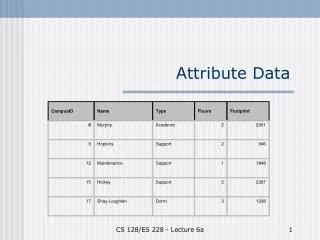
CampusID Name Type Floors Footprint 6 Murphy Academic 2 2001 9 Hopkins Support 2 946 12 Maintenance Support 1 1848 15 Hickey Support 2 2367 17 Shay-Loughlen Dorm 3 1298 How is Attribute Data kept in a GIS? Attribute data is generally stored in database tables. CS 128/ES 228 - Lecture 2b
How is Attribute Data extracted from a GIS? • GIS’s have two main types of output • Reports • Maps • As always, these can be combined CS 128/ES 228 - Lecture 2b
Reports • A Geographic Information System is, at its core, a database. • Good database software always has a report generator. (We have something called Crystal Reports.) • Ergo, one can produce reports from a GIS. CS 128/ES 228 - Lecture 2b
Maps • A picture is worth 1000 words • What attribute data is being shown? CS 128/ES 228 - Lecture 2b
How is the Data Shown? Symbolization Issues: • Realistic vs. abstract symbols • Size, texture, and density • Use of color CS 128/ES 228 - Lecture 2b
Visual Display of Attribute Data • Easy for discrete features • There are many ways to represent continuous features on a map • Beware of the boundaries between classifications – they’re not usually very meaningful CS 128/ES 228 - Lecture 2b
How do we distinguish among our data values? Dichotomous scale (i.e. two classes) • Each class quite heterogeneous • Placement of boundaries is extremely sensitive to data density & quality CS 128/ES 228 - Lecture 2b
How many classes to use? Multiple classes: • Classes more homogeneous • Large number of classes hard to interpret Note: density of symbols should match the quantitative order of the classes, i.e. greater density => greater value CS 128/ES 228 - Lecture 2b
How shall we determine the class limits? 1. Intervals of constant size CS 128/ES 228 - Lecture 2b
How to set class limits? 2. Intervals that have equal numbers of cells (equal class size) CS 128/ES 228 - Lecture 2b
How to set class limits? 3. Natural breaks in distribution CS 128/ES 228 - Lecture 2b
A GIS Riddle • Q: When is a map not a map? • A: When we call is something else. • Q: Why would we do this? • A: Because we do… CS 128/ES 228 - Lecture 2b
Thinking about the data in a map How “processed” is the data? Not at all Some Lots Image Maps Line Maps Cartograms (Choropleths) CS 128/ES 228 - Lecture 2b
Image maps (unprocessed data) • Composed of images of the area under study (usually aerial photos) • Often pieced together to make “mosaics” CS 128/ES 228 - Lecture 2b
Advantages of image maps • What you see is what is there (assuming the photo is current) CS 128/ES 228 - Lecture 2b
Problems with Image Maps • Interpretation • Details can be tricky – perspective is unusual (see math at right) • Distortion • Especially near edges and seams • No annotation CS 128/ES 228 - Lecture 2b
Line Maps (Somewhat processed data?) • Reality is replaced by “reality-based” renderings • “Raw” data is replaced by a representation of that data CS 128/ES 228 - Lecture 2b
Advantages of Line Maps • Can concentrate on information “of interest” • “Easy” to understand CS 128/ES 228 - Lecture 2b
Disadvantages of Line Maps • Data is not as accurate due to: • Incompleteness • Representation (especially scaling) • Deliberate “editorial” changes (see Exaggeration from previous lecture) CS 128/ES 228 - Lecture 2b
Cartograms (Choropleths) • Similar to line maps, but geographic data is deliberately distorted to make some other point CS 128/ES 228 - Lecture 2b
Strengths Highlight exactly what is desired Strong visual imagery Weaknesses Not useful outside initially intended domain Relatively difficult to produce Lots of information is lost Utility of Cartograms CS 128/ES 228 - Lecture 2b
Question??? • Is a cartogram a map? CS 128/ES 228 - Lecture 2b
Other types • It is not uncommon to combine some of these types • Cartographically Enhanced Image Maps are particularly common • For example, the map we use in lab CS 128/ES 228 - Lecture 2b
Map Forms • Historically, maps have been static, e.g. on sheets of paper • Computer technology has rendered maps dynamic and/or interactive CS 128/ES 228 - Lecture 2b
Two “dynamic” maps CS 128/ES 228 - Lecture 2b
One last issue • When do we compute using the attribute data? CS 128/ES 228 - Lecture 2b
Early Processing… • Compute your answers early and then reveal them when asked. • Commonly done for systems such as search engines CS 128/ES 228 - Lecture 2b
Late Processing… • Store only your data; compute answers as needed • MapQuest does this, as requests can’t be known in advance CS 128/ES 228 - Lecture 2b
Hybrid • Do some processing early, do some late • It is usually hard to detect that this is happening • “Caching” is one (not so good) example of this approach. • (Not so good because caching isn’t really processing, per se) CS 128/ES 228 - Lecture 2b
Conclusions • A map is interesting, but a map that highlights attribute data is useful • There are tradeoffs between completeness of information and ease of user processing • Caveat user! CS 128/ES 228 - Lecture 2b