Download
1 / 12
130 likes | 325 Views
ArcGIS HEC-RAS Interface Data Model “RASHydro”. July, 2003. Objectives. Transform the pre- and post- file structure of HEC-RAS into a geodatabase format Provide a geographic database for HEC-RAS information content for reverse-engineering purposes

E N D
Objectives • Transform the pre- and post- file structure of HEC-RAS into a geodatabase format • Provide a geographic database for HEC-RAS information content for reverse-engineering purposes • Take advantage of existing spatial functionalities in Arc Hydro data models and HEC-GeoRAS pre- and post- processor for floodplain analysis • Facilitate model connectivity/interface with external applications
Geodatabase Design Formatting a model-content geodatabase with HEC-RAS data storage structure to add interface functionalities A Model Interface GDB Visio 2000 UML ArcGIS Repository Geodatabase Schema
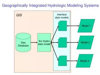
Model Associations are Preserved Maintains relationships between hydrologic elements in HEC-RAS model, features in RASHydro geodatabase, and ArcHydro Arc Hydro HydroID RAS Interface FeatureID ModelID
Equivalent Representation of Model Content RASHydro geodatabase HEC-RAS files
Main Components • Geometry Import File Feature Dataset • Geographic Data Export File Feature Dataset • ProfileLine feature dataset • Cross Section feature dataset • Time Series object classes
Final Remarks • A work in progress and some refinements and extensions still need to be done • Inclusion of bridges and culverts, levees, Ineffective flow areas, weirs, and blocked obstructions needs to be done • Final version of the HEC-RAS interface geodatabase should include all possible set up configurations and options to store the complete Model representation of the project at hand