Download
1 / 53
530 likes | 835 Views
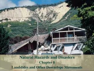
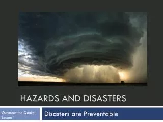
Natural Hazards and Disasters Chapter 13 Waves, Beaches and Coastal Erosion. Coastal Cliff Collapse. Pacifica, California: homes built along cliff of high terrace

E N D
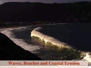
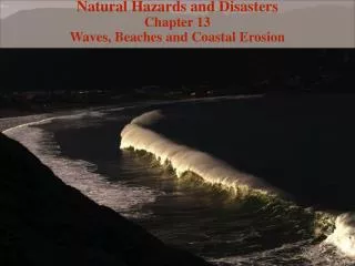
Natural Hazards and Disasters Chapter 13 Waves, Beaches and Coastal Erosion
Coastal Cliff Collapse Pacifica, California: homes built along cliff of high terrace Erosion of terrace accelerated in recent decades, as rivers from Sierra Nevada and coastal ranges bring less sediment (trapped by dams) Riprap along section of base of cliff slowed erosion temporarily, then that section showed even more erosion Rows of houses destroyed until only two remain
Living on Dangerous Coasts Early coastal structures built on stilts, on landward side of barrier islands, with temporary structures on beach Technologies of early 1800s led to deforestation, cultivation, overgrazing, which all increased erosion Erosion contributed to increase in sediment supply along coasts, which caused widespread enlargement of beaches Increase in spending money and leisure time led to growth in coastal tourism, especially after 1940s Coastal homes, hotels, resorts built along beaches By 2004, about 42% of population lived in coastal counties and continues to increase
Living on Dangerous Coasts Beaches and sea cliffs constantly change, and coastal processes do not stop People build ‘permanent’ structures at coast, try to hold back sea and prevent natural changes Effects of hurricanes are normal part of evolving landscape – seen as ‘nature on a rampage’ Human activities can affect wave action, beach response, sea-cliff collapse
Coastal Landforms • Two primary types, erosional and depositional (aka emerging and submerging) • ErosionalCoastlines • Rugged • Higher relief • Tectonically active areas • Leading edge of drifting continental plate • Sea cliffs • Sea caves • Sea arches • Sea stacks
Sea stack and arch Étretat, France
London Arch, Victoria, Australia Durdle Door Dorset, England Kalaupapa Cliffs Molaka’i, Hawaii over 1,000 meters high
Coastal Landforms • Depositionallandforms • Flat • Gentle relief • Not tectonic • Trailing edge of continental drift • Barrier spit – narrow extension from the coast • Bay barrier – cut off that forms lagoons • Lagoon – bay cut off from ocean • Tombolo – connects an offshore island
Sand spit Long Point, Ontario, Canada Long Point Provincial Park is a World Heritage Site Birds use Long Point as a stopping ground prior to crossing Lake Erie. Depositional landform produced by longshore drift – a sandbar is deposited where the longshore movement is interrupted by a coastal opening (cove, bay, etc.)
Farewell Spit South Island New Zealand
Coastal Landforms • Beaches • Technically the area along a coast where sediment is in motion from waves • Mostly quartz sand (bare mineral of SiO2) • Some are black-sand basalt beaches (Hawaii) • Shingle beaches made of larger cobbles (France) • Rugged shore like in Maine and Canada • Acts as the land’s energy absorber from the ocean
Tombolos Stockton Is, Wisc Deposit between an island and the mainland Wave refraction assists in helping target deposits along the tombolo Some tombolos occur in areas where sea level rise (isostatic rebound) has occurred Aupouri Peninsula North Island New Zealand
Waves and Sediment Transport • Winds blowing across sea push water surface into waves • Friction between air and water • Very unlike tsunamis • Wind-driven waves described in terms of • Wave height • Wavelength • Period • Height of wave increased by • Fetch: length of water surface over which wind blows • Amount of time wind blows across water surface
Waves and Sediment Transport • Waves generated with different sizes and moving at different speeds • Can interfere to increase or decrease size of combination giant rogue waves • Offshore: • Water has circular motion within wave • Waves approaching shore: • Begin to ‘feel bottom’ where water depth is less than half wavelength • Waves slow in shallow water but rise in height, causing them to break • Wave energy is proportional to mass of moving water
By the Numbers Wave Velocity Wave velocity in deep water is proportional to square root of wavelength: v = (gL/2pi)1/2 = 1.25L1/2 where: v = velocity (m/sec) L = wavelength (m) g = acceleration of gravity (9.8 m/sec2) p = 3.1416
By the Numbers Wave Velocity Wave velocity in shallow water is proportional to square root of water depth: V = (gD)1/2 = 3.1D1/2 where: V = velocity (m/sec) D = water depth (m) g = acceleration of gravity (9.8 m/sec2)
By the Numbers Wave Energy Doubling wave height quadruples energy: Ew = 0.125rgH2L where: Ew = energy of wave r = water density (g/cm3; close to 1) g = acceleration of gravity (9.8 m/sec2) H = wave height (m) L = wavelength (m)
Wave Refraction and Longshore Drift Waves often approach shore at angle Part of wave in shallower water slows down Part of wave still in deeper water moves faster Crest of wave curves around toward shore Wave refraction: waves bend or refract toward shore Breaking wave pushes sand grains up beach at angle Retreating wave flows down beach slope (with sand) perpendicular to water’s edge Angled waves create longshore drift, carrying sand along shore over time
Waves on Irregular Coastlines Waves approaching steep coast encounter headlands – rocky points that reach into deeper water, with shallower sandy bays between Waves refract toward headlands, dissipating wave energy Sand from eroded headlands is dumped in quiet bay Over time, wave activity tends to straighten coastlines
Rip Currents Waves pile up water onshore Water streams back offshore where deeper water reaches beach Creates rip current Scalloped shoreline, muddy streams in water may indicate rip currents Rip currents may appear unexpectedly with large swell from distant storm Escape rip current by swimming parallel to shore
Coastal Landforms • Barrier islands • Off shore of 10% of the world’s beaches • North Carolina and Texas are well-known US barrier island sites (Padre Island) • Form on shallow offshore sandbeds • Depositional or from sea level changes • Protect mainland from storm swells
Erosion of Gently Sloping Coasts and Barrier Islands • Beach on gently-sloping shoreline becomes steeper toward shore • Builds offshore barrier island • Area below sea level farther landward is coastal lagoon • Products of dynamic coastline processes: • Erosion • Deposition • Longshore sand drift • Wind transport • Barrier islands form along gently sloping coastlines of East and Gulf coasts of U.S. • Form across mouths of shallow bays and estuaries on West coast (after sea level rise after last ice age)
Erosion of Gently Sloping Coasts and Barrier Islands Wave-base erosion and deposition to form continental shelves may be related to 100-m lower sea level for thousands of years during last ice age 12-15,000 years ago, continental ice sheets melted and sea level rose Waves gradually moved sands on continental shelf landward, piled up as barrier islands Part of active beach, constantly shifting by wave and storm action Most less than 4 km wide, less than 3 m above sea level Inlets between barrier islands shift position with time Barrier islands migrate with change in sea level
Development on Barrier Islands Barrier islands protect coastal areas from storm wave and flood damage Hazardous places to live Many now crowded with buildings Beaches erode in front of buildings Boulders placed on beach reflect waves, hasten sand erosion Inlets kept open by dredging, by building jetties Newly opened inlet usually grows quickly unless filled back in Coastal construction control line in Florida imposed higher standards for land use and construction
Dunes • At low tide, winds pick up sand and blow it landward to form sand dunes • Dunes help to maintain barrier islands • Many dunes have disappeared as result of development • Dunes are leveled for building or views • Vegetation is removed deliberately or inadvertently • Sand is moved for construction, marinas, reclaiming beaches • Construction on dunes leads to sand removal • Dunes can be protected by • Elevating buildings on pilings • Elevated walkways over dunes • Trapping sand with sand fences • Dune nourishment projects • Vegetation to stabilize sand
Sea-Cliff Erosion • Sea cliffs of soft sediment will continually be eroded and collapse • Erosionally resistant rocks hold up some steep coastlines with rocky headlands • Raised marine terraces are often soft and easily eroded • Main factors affecting cliff erosion are • Rock strength • Wave height • Sea level • Precipitation
Sea Cliff Cliffs of Moher, Ireland
Sea-Cliff Erosion • Homeowners on cliff-tops sometimes exacerbate problem of erosion • Clear beach of driftwood that would help break force of waves • Make paths down steep slopes, cut steps, excavate for foundations • Add water to ground (weakening it) by irrigation, drainage • Response to signs of erosion is often to add coarse rocks or wall to beach • Resistant barrier concentrates wave action to create deep trough, into which barrier eventually collapses
Human Intervention and Mitigation of Coastal Change Typical response to threat to beachfront or cliff-top property is to build structures to protect communities: beach hardening Structures actually contribute to further erosion Recent developments in beach management include beach nourishment and zoning
Engineered Beach Protection Structures • Seawalls • Waves reflect off barrier, stir sand to deeper levels, carry sand offshore • Beach becomes narrower and steeper • Often hastens erosion and removal of beach • Groins • Barriers built into surf to trap sand from migrating down shore • Collect sand on upstream sides • Jetties • Maintain channels for boat access • Block sand migration along beach • Breakwaters • Cause deposition in protected area behind barrier • All barriers cause erosion on downstream side
Beach Replenishment • Replacing sand on severely eroded beaches • 56 large federal projects between 1950 and 1993 • U.S. Army Corps of Engineers placed 144 million cubic meters of sand on 364 km of coast • Sand taken from sand-accumulation shore areas, offshore areas • Dredged from ocean bottom or suction-pumped to surface • Operation may add sand up coast, allow longshore drift to distribute downstream • Natural coastal processes cause migration of sand away from beaches • Small-scale nourishment often needed every 2-6 years • Sand contributed to shallow offshore area is seen as wasted, even if builds up equilibrium profile appropriately