Download
1 / 22
220 likes | 374 Views
Effect of High Resolution Altimetric Gravity Anomalies on the North America Geoid Computations. Yan M. Wang and D. Roman National Geodetic Survey NOAA Montreal, Canada, May 17-21, 2004. Recent geoid computations at NGS.

E N D
Effect of High Resolution Altimetric Gravity Anomalies on the North America Geoid Computations Yan M. Wang and D. Roman National Geodetic Survey NOAA Montreal, Canada, May 17-21, 2004
Recent geoid computations at NGS • Milbert, D. G., 1991b: GEOID90: A high-resolution geoid for the United States. Eos, 72(49), pp. 545-554. • Smith, D.A. and D.G. Milbert, 1999: The GEOID96 high resolution geoid height model for the United States, Journal of Geodesy, V. 73, N. 5, pp. 219-236. • Roman, D.R. and D.A. Smith, 2000, Recent investigations toward achieving a one centimeter geoid, presented at GGG2000 session 9 of the IAG Symposium in Banff, Alberta, Canada from July 31 - August 4, 2000. • Roman, et al., Assessment of the New National Geoid Height Model, GEOID03 , ACSM Meeting, 4/19, 2004.
Gravimetric geoid computation Stokes integral /1DFFT • Topographic reduction: terrain correction at 1/3/30 arc seconds • EGM96 remove/restore: gravity anomaly of the reference model is removed, reference geoid is added back to residual geoid • Indirect effect
Data Used for USGG2003 • NGS gravity database: 1,264,372 • NIMA gravity data: 2,064,898 • Altimetric gravity anomaly: 688,876 • GTOPO30 and NGSDEM99 • EGM96 global gravity model up to degree and order 360 • Ellipsoidal correction from Sideris et al. (2003)
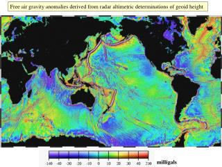
Conclusions • Altimetry gravity models differ at ±3 mgal RMS values (excluding few outliers in KMS99) • Geoid differences can reach 10 cm in coastal regions (land area), few cm in areas thousand miles away from the ocean • Geoid changes caused by GSFC00.1 improve the US gravimetric geoid
Conclusions (cont.) • Sea surface topography implied by GSFC00.1 MSS and USGG03 closely emulate the POCM4b • Ocean/land interface problems (diff. reference systems, lack gravity data)
Web Information • http://www.ngs.noaa.gov/GEOID/PRESENTATIONS/