Download
1 / 13
130 likes | 245 Views
Join me, Rachel Sutherland, on an exciting journey exploring Michigan's breathtaking landscapes! We traveled to iconic destinations like Sleeping Bear Dunes National Lakeshore and Mackinac Island. Experience the stunning geological formations shaped over millennia, from majestic dunes to picturesque waterfalls. Enjoy a serene canoe trip on the Platte River and witness abundant wildlife. Explore the wonders of Pictured Rocks National Lakeshore, including the fascinating Miners Castle. Discover why Michigan’s natural beauty is worth your visit!

E N D
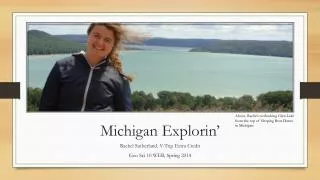
Above, Rachel overlooking Glen Lake from the top of Sleeping Bear Dunes in Michigan. Michigan Explorin’ Rachel Sutherland, V-Trip Extra Credit Geo Sci 10 WEB, Spring 2014
This past summer, my family and I took a road trip to one of our favorite states, Michigan! We traveled up the western coast of Michigan and to the Upper Peninsula also to visit places like Mackinac Island, Sleeping Bear Dunes National Lakeshore, and Pictured Rocks National Lakeshore! Come along as we learn about the vast geological history of this beautiful area! The Sutherland Family overlooking Mackinac Bridge and Lake Huron/Lake Michigan
Canoeing the Platte River The Platte river is located on the western coast of Michigan. It is a part of Sleeping Bear Dunes National Lakeshore. The river winds its way from the town of Honor, MI until it deposits in Lake Michigan. Lake Michigan is 1 of the 5 Great Lakes that surround Michigan. It is so large, many think of it more like an ocean although it is freshwater. Along the canoe trip, my family and I saw lots of wildlife also. Especially present were many types of cranes as well as salmon and other animals. The sun was shining and the weather was pristine for a nice canoe trip! (Left, Rachel canoeing on her way to Lake Michigan!)
Climbing the Sleeping Bear Dunes Sleeping Bear Dunes are natural dunes that border Lake Michigan on the western coast of Michigan. The dunes themselves are over 200 feet tall and extend far higher than this picture shows! These dunes were created during the ice age when glaciers created the Great Lakes and also created when is known as “Perched Dunes” where sand is placed very high above the river valleys formed also by the glaciers. It’s quite a hike to the top but a magnificent view (see title slide!). (above, Rachel at the base of the Sleeping Bear Dunes “dune climb”)
Sable Falls Upper Peninsula, MI Sable Falls is located in the Upper Peninsula of Michigan and within Pictured Rocks National Lakeshore. This beautiful waterfall is one of many along the lakeshore. Sable Falls flows directly into Lake Superior which is a short walk from the falls. The falls flow over geological sandstone formations on their way to the lake. On the right is a picture of an interesting wood formation I saw just down the river from the falls. I thought it looked like the head of a bird although it was formed naturally by the current of the river from the falls The interesting wood formation Rachel found in the river below the falls (Rachel and her brother watching Sable Falls)
Miners Castle Pictured Rocks National Lakeshore, MI Miners Castle is a natural rock formation that is located in Pictured Rocks National Lakeshore in the Upper Peninsula of Michigan. It is made up of sandstone from many different eras that date all the way back to Pre-Cambrian and Paleozoic. When the sand was deposited, it was shaped based on the way the waves moved in the lake. Some colors can also be seen here throughout the structure. This comes from the minerals in the water that stain the sandstone when they hit it. Based on how sediment was moved to and from the structure, colors and patterns were created that developed this beautiful structure we see today!
Boat tours take tourists to see the beautifully mineral stained rocks further up along Pictured Rocks National Lakeshore
Mackinac Island, Upper Peninsula, MI Mackinac Island is one of my favorite places in Michigan. It is a quaint little island that can only be gotten to by ferry. On the island, there is no automotive transportation. Residents and tourists get around the island by bike and horse-drawn carriage. Mackinac Island used to be the location of a military fort and also maintains a state park with many geological formations such as Arch Rock, Devil’s Kitchen, and Sugar Loaf
Above, Stunning view of Lake Michigan from the top of Mackinac Island Below, Grand Hotel on Mackinac Island as seen from the ferry Map of Mackinac Island State Park on Mackinac Island, MI
(Below) Devil’s Kitchen is a sea cave that was hollowed out by the lake. This occurred over 350 million years ago and is one of the youngest formations on the island (Below) Sugar Loaf is a 35 foot high formation on the island that is made of limestone breccia formed after a glacial period nearby (Above) Arch Rock is formed from lake erosion where the center of the rock was hollowed out by the lake and is made of the same limestone breccia as other formations on the island
Thanks for coming on my V-trip throughout Michigan and all the wonderful geological features seen there! Hope you’ll consider a trip to the western coast and Upper Peninsula of Michigan! –Rachel Sutherland
Works Citedhttp://www.nps.gov/piro/planyourvisit/waterfalls.htmhttp://www.nps.gov/piro/planyourvisit/upload/MinersCastle2013.pdfhttp://www.michigan.org/hot-spots/mackinac-island/*Additional information was attained from information plaques seen and visitor guides collected while on the trip.** All pictures included were taken by Rachel Sutherland and her mother, Gail Sutherland