Download
1 / 39
390 likes | 418 Views
Dive into the intricate patterns of atmospheric circulation, from global to synoptic scales, examining 3-cell models, ITCZ effects, jet streams, and more. Understand how mesoscale and microscale circulations influence local weather phenomena.

E N D
Atmospheric Circulation Chapter 7
Atmospheric circulation • Global – Covers major portions of the earth • Synoptic – covers 100s to 1000s of km2 • Mesoscale – covers 10 of km2 • Microscale – small exchanges of mater and energy
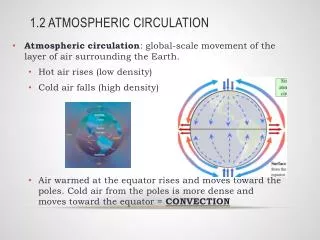
Single cell model • George Hadley The earth is warmed at the equator. Air expands upward and diverges toward the pole At the pole air cools and flows back toward the equator
Single cell model Because the earth is rotating the wind is shifted to the right (left in SH)
Single cell model Zonal winds – blow east to west or west to east Meridional winds – blow south to north or north to south
Single cell model Not a very realistic model
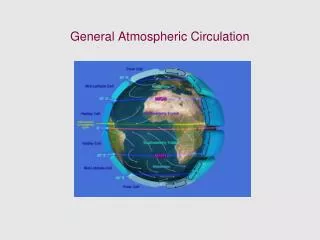
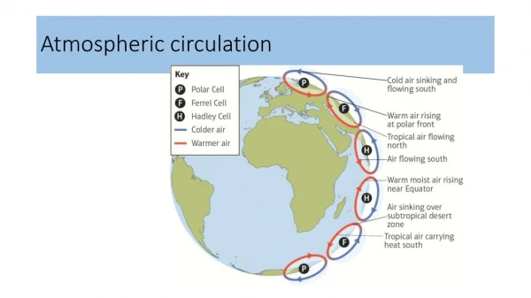
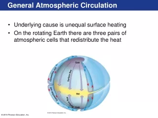
3-cell model • Each hemisphere is divided into 3 distinct circulation cells
3-cell model • Polar cell • Ferrel cell • Hadley cell Each cell has associated pressure and wind patterns
3-cell model ITCZ = Intertropical convergence zone Creates the equatorial low, rainiest regions on earth Little wind – doldrums
3-cell model 20-300 Subtropical High – very dry Location of many of the earth’s deserts Little wind – horse latitudes Between 0-200 NE trade winds
3-cell model Subpolar low – plenty of rain Mid latitude westerlies Polar high – pretty dry Polar easterlies
3-cell model Is OK at explaining some pressure and wind phenomena. Ex ITCZ
The “real” world • Not covered by distinct belts that completely encircle the earth • Circulation is dominated by semi-permanent cells of low or high pressure
Winter • Weather in the North America is dominated by the Aleutian Low and Icelandic Low
Summer • Weather in North America is dominated by the Hawaiian High and the Bermuda-Azores High
The jet stream The pressure gradient force increases with height
The jet stream The Polar front is a boundary between very cold polar air and warmer mid-latitude air Creates an extreme Pressure Gradient force
The jet stream The result is a powerful flow of air, the jet stream, located near the tropopause at the polar front
Ridges and troughs • Ridges – thicker regions of the atmosphere with higher pressure, often associated with surface divergence • Troughs – thinner regions of the atmosphere with lower pressure, often associated with surface convergence
Ridges and troughs Ridge Trough
Ridges and troughs • Can best be seen on a 500mb map • Troughs point toward the equator • Ridges point toward the pole 500mb map
Rossby Waves The ridges and troughs form long waves, called Rossby waves, which circle each hemisphere. Rossby waves can remain stationary or move west to east Movement of the waves can transport vast amounts of air
Rossby waves Groovy web animation
Ocean Currents • Large scale movements of surface water that can exchange energy and moisture with the atmosphere
Foehn winds • Winds that flow down mountain slopes, warm by compression and bring warm dry air to the lowlands • Chinook – formed by air descending the eastern slopes of the Rocky Mountains • Santa Ana – formed by high pressure over the Rockies and Great Basin
Sea / land breezes • Sea breeze • Land warms faster in the day then water • Causes air to expand, rise, diverge and thus create low pressure • Air moves from the sea to balance the pressure • Land breeze • At night the land cools faster than the water and the situation is reversed
Mountain / valley breezes • Valley breeze • Daytime heating of the mountain causes air to warm, rise and be replaced by • air from the valley • Mountain breeze • At night the mountain cools an air sinks down to the valley