Download
1 / 2
20 likes | 102 Views
S A L P. Hommes. Matériels. Logiciels.

E N D
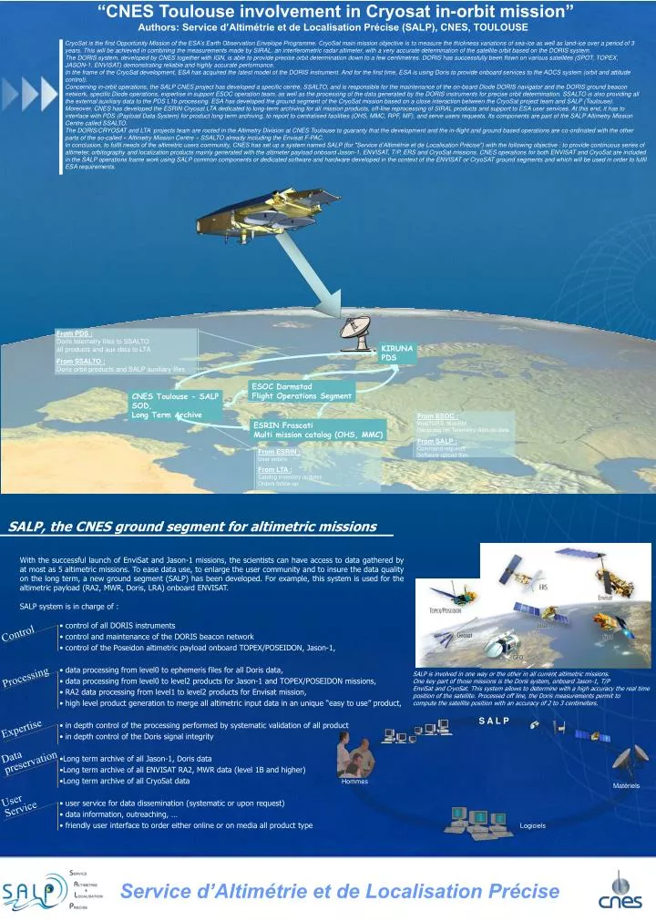
S A L P Hommes Matériels Logiciels CryoSat is the first Opportunity Mission of the ESA’s Earth Observation Envelope Programme. CryoSat main mission objective is to measure the thickness variations of sea-ice as well as land-ice over a period of 3 years. This will be achieved in combining the measurements made by SIRAL, an interferometric radar altimeter, with a very accurate determination of the satellite orbit based on the DORIS system. The DORIS system, developed by CNES together with IGN, is able to provide precise orbit determination down to a few centimetres. DORIS has successfully been flown on various satellites (SPOT, TOPEX, JASON-1, ENVISAT) demonstrating reliable and highly accurate performance. In the frame of the CryoSat development, ESA has acquired the latest model of the DORIS instrument. And for the first time, ESA is using Doris to provide onboard services to the AOCS system (orbit and attitude control). Concerning in-orbit operations, the SALP CNES project has developed a specific centre, SSALTO, and is responsible for the maintenance of the on-board Diode DORIS navigator and the DORIS ground beacon network, specific Diode operations, expertise in support ESOC operation team, as well as the processing of the data generated by the DORIS instruments for precise orbit determination. SSALTO is also providing all the external auxiliary data to the PDS L1b processing. ESA has developed the ground segment of the CryoSat mission based on a close interaction between the CryoSat project team and SALP (Toulouse). Moreover, CNES has developed the ESRIN Cryosat LTA dedicated to long-term archiving for all mission products, off-line reprocessing of SIRAL products and support to ESA user services. At this end, it has to interface with PDS (Payload Data System) for product long term archiving, to report to centralised facilities (OHS, MMC, RPF, MF), and serve users requests. Its components are part of the SALP Altimetry Mission Centre called SSALTO. The DORIS/CRYOSAT and LTA projects team are rooted in the Altimetry Division at CNES Toulouse to guaranty that the development and the in-flight and ground based operations are co-ordinated with the other parts of the so-called « Altimetry Mission Centre » SSALTO already including the Envisat F-PAC. In conclusion, to fulfil needs of the altimetric users community, CNES has set up a system named SALP (for "Service d’Altimétrie et de Localisation Précise") with the following objective : to provide continuous series of altimeter, orbitography and localization products mainly generated with the altimeter payload onboard Jason-1, ENVISAT, T/P, ERS and CryoSat missions. CNES operations for both ENVISAT and CryoSat are included in the SALP operations frame work using SALP common components or dedicated software and hardware developed in the context of the ENVISAT or CryoSAT ground segments and which will be used in order to fulfil ESA requirements. From PDS : Doris telemetry files to SSALTO all products and aux data to LTA From SSALTO : Doris orbit products and SALP auxiliary files KIRUNA PDS ESOC Darmstad Flight Operations Segment CNES Toulouse - SALP SOD, Long Term Archive From ESOC : WebTDRS, WebRMRecorded HK Telemetry, Attitude data From SALP : Command requests Software upload files ESRIN Frascati Multi mission catalog (OHS, MMC) From ESRIN : User orders From LTA : Catalog inventory updates Orders follow-up “CNES Toulouse involvement in Cryosat in-orbit mission” Authors: Service d’Altimétrie et de Localisation Précise (SALP), CNES, TOULOUSE SALP, the CNES ground segment for altimetric missions • With the successful launch of EnviSat and Jason-1 missions, the scientists can have access to data gathered by at most as 5 altimetric missions. To ease data use, to enlarge the user community and to insure the data quality on the long term, a new ground segment (SALP) has been developed. For example, this system is used for the altimetric payload (RA2, MWR, Doris, LRA) onboard ENVISAT. • SALP system is in charge of : • control of all DORIS instruments • control and maintenance of the DORIS beacon network • control of the Poseidon altimetric payload onboard TOPEX/POSEIDON, Jason-1, • data processing from level0 to ephemeris files for all Doris data, • data processing from level0 to level2 products for Jason-1 and TOPEX/POSEIDON missions, • RA2 data processing from level1 to level2 products for Envisat mission, • high level product generation to merge all altimetric input data in an unique “easy to use” product, • in depth control of the processing performed by systematic validation of all product • in depth control of the Doris signal integrity • Long term archive of all Jason-1, Doris data • Long term archive of all ENVISAT RA2, MWR data (level 1B and higher) • Long term archive of all CryoSat data • user service for data dissemination (systematic or upon request) • data information, outreaching, … • friendly user interface to order either online or on media all product type Control Processing SALP is involved in one way or the other in all current altimetric missions. One key part of those missions is the Doris system, onboard Jason-1, T/P EnviSat and CryoSat. This system allows to determine with a high accuracy the real time position of the satellite. Processed off line, the Doris measurements permit to compute the satellite position with an accuracy of 2 to 3 centimeters. Expertise Data preservation User Service Service d’Altimétrie et de Localisation Précise
Doris system Diode, a real time localisation service • Unlike the Global Positioning System (GPS), which beams signals from a constellation of satellites to Earth (or to other satellites in lower orbits), Doris uplinks signals to satellites. Collection of data on the satellite and at the SSALTO multi mission control and processing center makes the system particularly robust and is a definite advantage for distributing products in near-real time. It also facilitates the use of a single timing scale. An uplink system also allows the station network to be monitored remotely, thus significantly improving the quality. • The Doris instrument is part of the satellite payload. It comprises an MVR receiver that measures radial velocity, an ultra stable oscillator which insure a datation accuracy of 1 to 2 micro seconds, and an antenna. Every 10 seconds, it measures the Doppler shift at two frequencies : 400 MHz and 2 GHz (400 MHz channel being used to correct for the ionospheric effects). • On ground, a network of 60 beacons emits signals. • Since the launch of the Spot 4 satellite in January 1998, the Diode navigator has added real-time measurement processing capability for satellite navigation. Every 10 seconds, the onboard software determines the satellite position. Onboard Jason-1 and Envisat satellites, the position of the satellite is routinely determine within 50 centimeters in 3D (in normal conditions) with an accuracy of about 10 to 15 centimeters on the radial axis. This allows real time or near real time delivery of precize altimetric data to the user community. • Moreover, onboard CryoSat, ESA is using DORIS/Diode capabilities to provide onboard services to the AOCS system (orbit and attitude control) LTA system The LTA system, part of CryoSat ground segment, will insure : • long term archiving of all CryoSat data • upon ESA request, reprocessing of CryoSat data (for example at the end of the Kiruna operations). • On demand user requests (the PDS being the nominal data distribution site during the CryoSat lifetime) This system has been designed using existing facilities already used for ENVISAT operations and part of the ground segment set up in place in Kiruna. Inside SALP system, this will allow in the future to develop higher level products as the one depicted below. SALP Altimetric Products SALP User Service: aviso@cls.fr; www.aviso.oceanobs.com study of ocean variability marine meteorology, ocean-atmosphere gas tranfer Ssalto/Duacs Along-Track Sea Level Anomalies Along-Track Wind / Wave data OSDR, RA2 WWV, Wind/Wave Media: FTP Delay: real time, delayed-time Satellites: Jason-1, T/P, Envisat NRT-SLA, DT-SLA Media: FTP, DVD Rom Delay: near-real time & delayed time Satellites: T/P, Jason-1, Envisat, GFO, ERS geophysical studies, expert use study of the general circulation Gridded Wind / Wave data Ssalto/Duacs Gridded Sea Level Anomalies NRT-MWind and NRT-MSWH Media: Live Access Server, Opendap Delay: near-real time Satellites: T/P, Jason-1, Envisat, GFO NRT-MSLA, DT-MSLA Media: FTP, DVD Rom, Live Access Server, Opendap & Images Delay: near-real time & delayed time Satellites: T/P, Jason-1, Envisat, GFO, ERS independently and merged Ssalto/Duacs Gridded Absolute Dynamic Topography NRT-MADT Media: FTP, Live Access Server, Opendap & Images Delay: near-real time Satellites: merged T/P, Jason-1, Envisat, GFO Geophysical Data Records IGDR, GDR Media: FTP, DVD Rom Delay: near-real time & delayed time Satellites: T/P, Jason-1, Envisat Ssalto/Duacs Along-Track Absolute Dynamic Topography Geophysical sensor data NRT-ADT Media: FTP Delay: near-real time Satellites: T/P, Jason-1, Envisat, GFO SGDR, Waveforms Media: DVD Rom Delay: delayed time Satellites: T/P, Jason-1, Envisat Service d’Altimétrie et de Localisation Précise