Download

1 / 8
90 likes | 349 Views
The Canadian Shield!. By: Briana Riker, Kara Palmer, Allison Grimes and Hannah Johnson . The 5 Themes!(:. Location. The coordinates of the Canadian Shield is: 43 degrees 42’ 59, 72” North & 79 degrees 20’ 26, 47” West Toronto is just a little North east of Detroit The Canadian Shield is ;

E N D
The Canadian Shield! By: Briana Riker, Kara Palmer, Allison Grimes and Hannah Johnson
Location • The coordinates of the Canadian Shield is: 43 degrees 42’ 59, 72” North & 79 degrees 20’ 26, 47” West • Toronto is just a little North east of Detroit • The Canadian Shield is ; 1.Northeast of the Great Lakes 2. Northeast of the Plains 3. West of the Atlantic Ocean
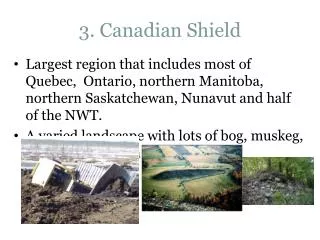
Place • Human Characteristics • Cars, buildings, trains, Roads & streets. • Physical Characteristics • Fields, rocky soil, grass lands, forests & mountains
Region • The Canadian Shield is U-Shaped. • The landscape is mostly grassy and rocky with low mountain ranges with few forests in the far north. • Not very populated in most areas. • Mostly populated near Detroit, the tip of the Canadian Shield. • Mostly populated near Detroit, the tip of the Canadian Shield. • Not a lot of farming because of the rocky soil.
Human/Environment Interaction • A lot of people in the Canadian shield do a lot of farm work, and make up most of the countries exports in crops. • They manufacture things like; copper, zinc, uranium, gold, and iron • Not a lot of farming because of the rocky soil. • People have to deal with shifting rainfall and extreme cold. • They have wind turbines that help with their crops.
Movement • People get around mainly by trains. Planes and cars are hard to use because of cold weather. • Railways are the main transportation. • Roads aren't used very much. • Mining and forestry are the main exports.
Ottawa Canada • Ottawa is a large city in the Canadian Shield. • In January 2011, the lowest temperature was -20 degrees Fahrenheit. The highest temperature was 48 degrees Fahrenheit. • In June 2011 the lowest temperature was 91 degrees Fahrenheit. The highest temperature was 44 degrees Fahrenheit.