Spatial Databases
Spatial Databases. DT249,DT211,DT228 Semester 2 2012-13 Lecture 0 Pat Browne. http://www.comp.dit.ie/pbrowne/Spatial%20Databases%20SDEV4005/Spatial%20Databases%20SDEV4005.htm. Your Interest in Spatial Databases Jobs in GIS. Government

Spatial Databases
E N D
Presentation Transcript
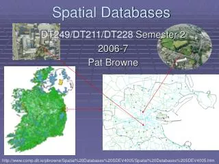
Spatial Databases DT249,DT211,DT228 Semester 2 2012-13 Lecture 0 Pat Browne http://www.comp.dit.ie/pbrowne/Spatial%20Databases%20SDEV4005/Spatial%20Databases%20SDEV4005.htm
Your Interest in Spatial Databases Jobs in GIS • Government • Most major departments are developing GIS on an ongoing basis: e.g. the Geological Survey of Ireland (GSI), Environment Protection Agency (EPA), Duchas, OPW. • Semi-states • Many agencies have a big investment in GIS e.g. ESB. • Local Authorities • County councils run many GIS applications. • Private Sector • MAPFLOW, IMGS (Information with location). • Post graduate research: • DIT Digital Media Centre (DMC), The National Centre for Geocomputation (Maynooth).
Fingal CC Fix our street http://www.fixyourstreet.ie/
Your Interest in Spatial Databases Technically Interesting • Spatial databases provided the essential logic and structure for a host useful and interesting applications (e.g. emergency services routing, hospital placement, game environments). • This spatial database course brings together many topics that you have already studied (e.g. databases, graphics, objection orientation, statistics) and applies them in innovative ways. • Spatial databases can answer a range of questions from “where is the nearest chipper?” to “How does Sellafield effect the Irish east coast?”. • Spatial database work with many other technologies (e.g. Internet ,wireless networks, and GPS.)
What is a Spatial Database? • A spatial database is a database system (DBMS) that is optimized to store and query basic spatial objects e.g.: • Point: a house, a moving car • Line: a road segment, road network • Polygon: a county, voting area • Which are usually augmented with spatial relations, thematic information, and temporal information, all expressed in a declarative way using a appropriate languages (e.g. SQL+spatial extensions).
Why Spatial Databases? • Queries to databases are posed in high level declarative manner (usually using SQL) • SQL is popular in the commercial database world. • Standard SQL operates on relatively simple data types. • SQL3/OGIS1 supports several spatial data types and operations. We will study the Open Geospatial Consortium Simple Features for SQL. • Additional spatial data types and operations can be defined in spatial database. (CREATE TYPE statement) • A DBMS is a way of storing information in a manner that • enforces consistency, • facilitates access, • Allows users to relate data from multiple tables together
Custom Applications Spatial Databases must integrate with other applications and data. HTML Viewer Java Viewer GIS Desktop Applications (Internet) Wireless Mobile Devices Network Map Renderer Server Side Applications Spatial DB
Spatial enabled DB Summary • Database – an integrated set of data on a particular subject. Can include spatial and non-spatial and temporal data. • Databases offer many advantages over files. • Relational databases dominate for non-spatial use, Object-relational database (ORDBMS) are used for spatial data. • Databases address some limitations for specialist or dedicated GIS.
Query 1 • “Display all counties that border Kildare”. • This query can be implemented using the following SQL command: select c1.name as name,transform(c1.the_geom,4326) as the_geom from county c1,county c2 where touches(c1.the_geom,c2.the_geom) and c2.name='Kildare';
Query 2 • “Display all regional roads that intersect the N7 National Primary Road within the region of Dublin Belgard” This query can be implemented using the following SQL command: SELECT asbinary(r.the_geom), r.class AS name FROM regional AS r,roads n,county AS c WHERE n.class='N7' AND c.name='Dublin Belgard' AND intersects(n.the_geom,r.the_geom) AND contains(c.the_geom,intersection(r.the_geom,n.the_geom));
Result 2 Results in red
Querying moving objects Find where and when will it snow given Clouds(X, Y, Time, humidity) Region(X, Y, Time, temperature) (SELECT x, y, time FROM Clouds WHERE humidity >= 80) INTERSECT (SELECT x, y, time FROM Region WHERE temperature <= 32)
Example Query • “How many people live within 5 miles of the toxic gas leak?”SELECT sum(population) FROM census_info WHERE distance(census_geom,’POINT(…)’) < 5 Toxic leak in Well Known Text (WKT) format
Example Query • “What is the combined area of all parks inside the Dublin postal district 1?”SELECT sum(area(park_geom)) FROM parks, postalDistrict WHERE contains(postalDistrict_geom,park_geom) AND postalDistrict_name = ‘Dublin 1’ Based on lecture from Paul Ramsey Refractions Research
Visualization of Information Population1
Example Query • What is the maximum distance a student has to travel to school?”SELECT max(distance(student_location, school_location )) FROM students, schools Based on lecture from Paul Ramsey Refractions Research
Networking • For enhanced network traversal and routing PostgreSQL/PostGIS can be extended with pgRouting software which can perform: • Shortest path search (with 3 different algorithms) • Traveling Salesperson Problem solution (TSP) • Driving distance geometry calculation http://pgrouting.postlbs.org/
Querying a non-spatial attribute Find the countries of western Europe with population greater than 50 million. This is a projection on the attribute population. Unlike a conventional database query we often want the query result and the original context, in this case Europe.
Formalizing Common Sense • It helps minimize the ambiguity data if it is properly formalized with respect to the real world. The following pair of signs are displayed at the foot of an escalator. What do they mean? They have exactly the grammatical structure. Dogs Must Be Carried Shoes Must Be Worn
Course Overview • This course focuses on the use of database management systems (DBMS) to store spatial information. A spatially enabled DBMS is a central component of a Geographical Information System (GIS). GIS has a major role to play in managing the nationalphysical and informational infrastructure. An understanding of spatially enabled DBMS is vital in implementing any information system where geographic data is required. This course focuses on the role of the DBMS in geographical applications.
Course Description 1 • Foundations Fundamental geographic concepts for GIS The world in spatial terms, how natural and man made features can be stored in a DBMS. We can have qualitative and quantitative location e.g. address and coordinate systems. These can be related using geo-referencing. Maps can be used as representation of the world and of information. We focus on topological, geometric, and thematic information.
Course Description 2 • Algorithms for GIS: Intersection of lines, operations on polygons, network traversal, auto-correlation, statistical operations, searching. We focus on the use of algorithms, not their design. The actual algorithms are provided as database extensions (e.g. PostGIS) or desktop GIS (e.g. OpenJump or uDig)
Course Description 3 • Spatial representations: Raster, vector, TIN, quadtrees, R-trees, scan orders, polygon coverage, discrete objects, networks, time, connections and topology, networks, distance and direction, flow and diffusion, spatial hierarchies, boundaries, spatial patterns, attributes of relationships. As with the algorithms the actual representations are provided by the DBMS extensions (via APIs) and GIS.
Course Description 4 • Applications of geospatial data: Transportation networks, natural resources, soil data, oceanography, land cover, geology, climate, terrain, land records, administrative boundary data, demographic studies, decision support and health data.
Course Description 5 • Spatial databasesSpatial data: definitions, formats, models, queries the relational model, advanced SQL, data modelling techniques, implementing a simple database, post relational database models, object-relational and object-oriented models, spatial data structures, spatial indexing e.g. R-Tree, networking, database issues in GIS. The course will involve practical work on a range of appropriate software e.g. PostgreSQL/PostGIS, MLPQ/Presto, R-statistical package, ArgoCaseGEO, uDIG, OpenJump, GeoServer, Openlayers.
Learning Outcomes • On completion of the spatial database module, you will be able to: • Use a database to store and query spatial data • Understand spatial modelling techniques. • Develop applications that use a spatially enabled DBMS • Understand and use the OGC standards GML, SFSQL1, WMS, WFS, WPS. • Distinguish and use appropriate database models • Understand the DBMS extensions and APIs required by application programs to handle spatial data.
Main Topics • Spatial database systems: PostgreSQL-PostGIS. • OGC “Simple Features for SQL” • Spatial statistics; spatial R • Geographic data on the web (e.g. Geoserver, Open Layers, Open Street Map, WMS,WFS,WPS) • Spatial systems in a social and economic context.
Geographic Markup languageGML GML can be loaded, saved and viewed using OpenJump
OGC Well Known Text http://en.wikipedia.org/wiki/Well-known_text
Main References http://www.spatial.cs.umn.edu/Book/ http://www.manning.com/obe/ Spatial Databases: With Application to GIS Rigaux, Scholl, Voisard http://ukcatalogue.oup.com/product/9780199554324.do#.UQkL1GeFng0/ GIS: A Computing Perspective http://www.pragprog.com/titles/sdgis/gis-for-web-developers
Software • PostgreSQL • PostGIS • pgRouting • Open Jump • Geoserver • R Language • A little Java & JavaScript • Data from: Ordnance Survey Ireland, Open Street Map (OSM), Central Statistics Office (CSO)