Download

1 / 1
120 likes | 640 Views
GEOLOGICAL SURVEY OF BANGLADESH Ministry of Power, Energy and Mineral Resources Energy and Mineral Resources Division Government of the People’s Republic of Bangladesh. Intruduction:

E N D
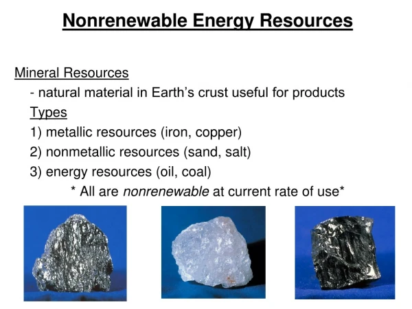
GEOLOGICAL SURVEY OF BANGLADESH Ministry of Power, Energy and Mineral Resources Energy and Mineral Resources Division Government of the People’s Republic of Bangladesh • Intruduction: • Geological Survey of Bangladesh (GSB) is a geoscientific research organization and attached to the Energy and Mineral Resources Division, Ministry of Power, Energy and Mineral Resources, Government of the People’s Republic of Bangladesh. In order to expedite exploration and evaluation of mineral resources GSB carryout various types of projects in different times. As a result, low sulfur high-grade bituminous coal at Barapukuria and Dighipara of Dinajpur and Khalaspir of Rangpur district, and Maddhyapara hard rock of Dinajpur district have discovered at shallower depth. Besides these, glass sand, white clay, limestone, peat and gravel deposits were discovered in different parts of the country. Moreover, a good number of resource persons of different aspects of geo-sciences have developed by training at home and abroad. Now wide range of research facilities are also available in different laboratories. Besides these, GSB has been also working in the field of urban infrastructure development, construction of engineering structures, land development in planned way and disaster management. GSB arranges field investigation to know the causes of natural calamities such as earthquake, flood, landslide, river erosion etc. and to aware the local people how to mitigate against those natural calamities. Identification of potable water aquifers, source and intensity of arsenic in ground water and different kinds of mapping belongs to the routine work of GSB. • GSB has been conducting different surveys by 18 geoscientific branches from the revenue and development projects. In June, 2009 GSB has been successfully completed three projects. At present one project under ADP and one project under German technical assistance have been implementing by GSB. Besides these, seven other projects are in the process of approval. • Organizational setup: • Director General is the chief of the Geological Survey of Bangladesh. There are 2 divisions headed by 2 Deputy Director Generals, and 18 branches under the divisions. Each branch is headed by a Director/ Superintending Geophysicist/Superintending Chemist/ Superinten- ding Drilling Engineer. Besides, GSB has a training centre and 3 cells headed by senior officers. The followings are the Branches of GSB: • Operation and Co-ordination • Planning and Implementation • Petrology and Mineralogy • Stratigraphy and Biostratigraphy • Geological Mapping & Quaternary Geology • Coastal and Marine Geology • Remote Sensing and GIS • Geochemical and Water Resources • Analytical Chemistry • Economic Geology & Resource Assessment • Environmental Geology & Natural Hazard • Urban & Engineering Geology • Drilling • Editing & Publication • Gravity and Magnetic Survey • Seismic and Electrical Resistivity Survey • Geophysical Data Analysis • Cartography, Printing & Photo lab • Training Centre: • Geoscience Awareness and Training Centre(GATC) • Cells: • Computer Cell • Earthquake Research Cell • Information Technology Cell • Duties and Responsibilities: • To conduct systematic geological mapping of the country. • To investigate in detail such areas as are indicated by geological mapping to be favorable for accumulation of industrial rock, mineral fuel, ground water and other natural resources. • To investigate in detail and conduct extensive geophysical, test drilling and geochemical operation in order to evaluate the known mineral deposits. • To conduct stratigraphic studies to identify, correlate and determine the sequence of rock units in support of mapping and exploration programmes, including age determination by fossils and other geochronological methods. • To conduct geological investigation in connection with construction of dams, canals, tunnels, highways, bridges, new townships and other public construction projects so as to advise the sponsoring agencies about geological feasibility of such construction projects. • To carry out marine geological and geophysical investigation and geomorphological studies of river basins and delta regions. • To undertake systematic sampling of mineral fuels and ground water resources and to carry out mineralogical and chemical analysis of the samples. • To conduct research in various fields of geology. • To advise the public and private organizations in all matters connected with geology and resources of the earth. • To conduct research and assessment of natural hazards like, flood, earthquake, bank erosion, arsenic contamination etc. Projects • Achievements • Geological Mapping • About 61,722 square kilometres area of the country including the coastal parts have so far been geologically mapped at the scale of 1: 50 000. These mapping programmes have been carried out in flood plain, coastal and hilly areas in different parts of the country. • Engineering Geology and Urban Geology • The mapping works of important cities at suitable scales (e.g. Dhaka including its surrounding areas, Rajshahi, Barisal, Rangpur, Bogra and Khulna) of the country have completed. • Drilling • 198 holes has been drilled so far in different parts of the country with a total drilling depth of about 49,969.30 metres for mineral exploration, stratigraphic studies, test holes and other geoscientific interests. • Mineral Exploration • Coal—Barapukuria (300*) and Dighipara (105) of • Dinajpur, Khalashpir (143) of Rangpur, and Jamalganj (1053) of Joypurhat districts. • Peat—Bagiachanda (150) of Gopalganj, Kola Mouza (8) of Khulna; Moulvibazar, and Charkai and Pagla of Sunamganj districts and Paharpur, Haraspur, Champaknagar and Uttar Singirbil(800) of Brahmanbaria district. • Limestone—Joypurhat (100) of Joypurhat, and • Takerghat, Lalghat (12.9) and Bagalibazar (17) of Sunamganj • districts, Kazipara & Paranagar, Naogaon District. • White Clay—Bijoypur (2.5) of Netrakona; • Barapukuria (25), Maddhaypara (15) and Dighipara** of Dinajpur; • and Patnitala** of Naogaon districts. • Glass sand—Balijuri (0.17) of Sherpur, Bahubal • and Shahjibazar (8) of Habiganj, Chouddagram (0.30) of Comilla, • Bhatera of Moulvibazar, Barapukuria (90), Maddhyapara (17.25) and Dighipara** of Dinajpur districts. • Mineral sand—Sea beaches of Cox’s Bazar, Moheshkhali and Kutubdia. • Hard Rock—Maddhyapara (115) of Dinajpur and Panbari** of Rangpur districts. • Gravel—Bholaganj (4) of Sunamganj, Patgram of Lalmonirhat, Tetulia (2.5) of Panchgarh, and Chittagong Hill Tracts (1.00) districts. • Limestone and White Clay deposits at Agair, Panchbibi, Joypurhat • Recently completed TAP project: • Building Ground InformationSystem of Dhaka City, Bangladesh (financed by FedaralRepublic of Germany) • Modernization of drilling equipment and accessories of the Geologocal Survey of Bangladesh for investigation of mineral resources. • Geo-scientific activities for the development of mineral resources. • Geological Survey of Bangladesh (GSB) has been working in a collaborative project with CDMP entitled “Data sharing, geological and geomorphological mapping with subsurface information of Dhaka, Chittagong and Sylhet City Corporations, Bangladesh”. • Geological exploration for identification of mineral resources and the areas vulnerable to natural hazards in the coastal parts of Bangladesh(2006-10)” • High Resolution Terrain Modeling of North-Eastern Part of Greater Dhaka City, Bangladesh (financed by FedaralRepublic of Germany). • Strengthening the Research and Exploration Capabilities of the Geological Survey of Bangladesh. • Enhance Institutional Support and Capacity Building for Mitigation of Geo-hazards in Bbangladesh • Currently on going Projects: • Strengthening the research and Exploration Capabilities of the Geological Survey of Bangladesh. • Integrated Geological Mapping of the Chalanbil Area to enveil the Quaternary Records and Climatic changes • Geo-scientific activities for the development of mineral resources (Phase 2). • Enhance Institutional Support and Capacity Building for Mitigation of Geo-hazards in Bangladesh- 2nd Phase Gondwana Coal at Dighipara Coal Basin Library, Data Centre and Museum GSB has a very rich library with more than 45,000 text books, journals and publilcations. Data Centre attached with library and more than 800 unpublished report/publications are available not for public. GSB also hosts a nice museum which offer some very valuable and rare samples of rocks and minerals, fossils, evolutionary trends of human being and few models are displayed for public. Publications: GSB published a number of reports on different disciplines of earth science on completed works carried out in different parts of the country. These reports consist of geological /geophysical maps with scales of 1:50 000 and 1: 2 50 000. Three important published maps (Scale1: 10 00 000) are i) Geological Map of Bangladesh, ii) Bouger Anomaly Map of Bangladesh and iii) Aeromagnetic Anomaly Map of Bangladesh. Besides these, the scientists of the department have been publishing their research findings in seminars/symposia and journals at home and abroad regularly. Some Important Features GSB is fully equipped with Rotary Conventional and Wire Line Drilling Units and capable of drilling more than 2000 metres. Analytical Chemical Laboratory upgraded with Atomic Absorption Spectrophotometer. Laboratories for Petrological, Sedimentological, Mineralogical and Palynological studies are equipped with modern equipments like X-ray diffractometer and Scanning Electron Microscope (SEM) etc. Engineering and Geotechnical Laboratory is well equipped to determine geotechnical characteristics of soil/rock for civil constructions. Geophysical survey branch equiped with modern gravity, magnetic, seismic and electrical surveying instruments and computerised data processing and well logging techniques. The department is continually upgrading its capabilities through training its geo-scientific manpower at home and abroad and procuring modern laboratory facilities. The Government of the People`s Republic of Bangladesh awarded “The Independence Day Award” to GSB in the field of science and technology in 1994 as the best scientific organization. • Future Plans: • Geoinformatics for Urban Development, Bangladesh • Strengthening the Research and Exploration Capabilities of the Geological Survey of Bangladesh. • Enhance institutional support and capacity building for mitigation of Establishment of Advanced Geoscience • Establishment of a Research Centre at Mirpur, Dhaka. • Study on the Geohazards in Bangladesh. • Geoscientific Activities for Mineral Investigation-3rd phase. • Aquifer Mapping for Remedial of Arsenic Contamination n the Groundwater of Bangladesh. • Establishment of sub-offices at Chittagong and Khulna GSB at Dhaka GSB at Bogra