Download
1 / 6
60 likes | 188 Views
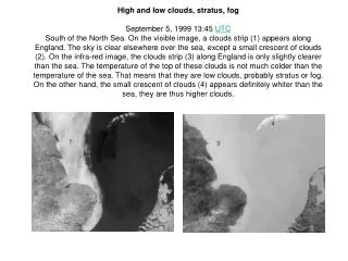
High and low clouds, stratus, fog September 5, 1999 13:45 UTC

E N D
High and low clouds, stratus, fog September 5, 1999 13:45 UTC South of the North Sea. On the visible image, a clouds strip (1) appears along England. The sky is clear elsewhere over the sea, except a small crescent of clouds (2). On the infra-red image, the clouds strip (3) along England is only slightly clearer than the sea. The temperature of the top of these clouds is not much colder than the temperature of the sea. That means that they are low clouds, probably stratus or fog. On the other hand, the small crescent of clouds (4) appears definitely whiter than the sea, they are thus higher clouds.
Cirrus, land - sea contrastsJune 24, 1999 16:28 UTCA cirrus strip crosses the area from North-West to south-east. They are thin clouds with a small reflectivity in visible. They dont appear clearly (1) on the visible image. They appear much brighter (2) in infra-red because, made of ice, they are very cold. The sea (3) is brighter than the land (4) on the infra-red image because, in this end of afternoon, it is colder. The sea (5) is darker than the land (6) on the visible image, because it absorbs more the solar
Wave clouds, thunderstorm May 17, 1999 18:18 UTCSouth of France. In the right bottom, this is the Mediterranean sea. A low over Spain generates a strong south to southeast wind over the Cevennes (1), which gives rise to wave clouds. Those are visible at the same time on the visible and infra-red images, in the shape of two slightly divergent strips (2). On the left of the images, there are thunderstorm clouds: cumulonimbus (3). Very white spots on the infra-red image, because their top, very high, is very cold. These clouds of large vertical extention have a significant shade (4) that can be seen on the visible image in the light of the evening.
High clouds, sea, mountains, forests June 20, 1998 13:59 UTCSouth-west of France by a heat day of June. On the infra-red image, the hot ground (1) appears very dark whereas the sea (2), colder, is brighter. In bottom of the image, the Pyrenees (3) are also brighter than the plain because the ground is less hot. On the visible image, the sea (4) is darker than the land (5), because it absorbs more the solar radiation. In the same way, the Landes forest (6) appears darker than the surrounding areas. Clouds over the sea (7) are white on the infra-red image. That means they are cold, and thus they are high clouds. On the visible image, these clouds are not easy to see: they are thin clouds. They are probably cirrus.
Cold fronts, showers, land - sea contrasts June 5, 1999 08:15 UTCA cold front (1) has just passed over the North-West of France. Behind, the sky is almost clear. The shade of the cloudy strip appears on the visible image. A secondary cold front (2) approaches Brittany. Thermal contrast is more significant: there are many shower clouds (3) behind this secondary front. The sea (4) does not differ from the land (5) on the infra-red image: their respective temperatures should be nearly the same. On the other hand, on the visible image, the sea (4) is much darker than the land (5), because it does not reflect the solar radiation as the land does.
Eruption of Etna, Sicily July 28, 2001 05:06 UTCSicily. The plume of smoke (1) from the eruption of Etna is pushed by a northwest wind. On the visible image, the shade of the plume covers the volcano. On the infrared image, a black zone, thus a warm one, is visible in the volcano crater area. Lipari islands (2) are also visible in the north of Sicily.