Download
1 / 37
370 likes | 477 Views
NAME : STATUS AND PLANS. NAME Homepage: http://www.joss.ucar.edu/name. http://www.joss.ucar.edu/name. OUTLINE. PROGRAM RATIONALE AND OBJECTIVES LINKAGES (PROGRAMS, AGENCIES, COUNTRIES) NAME 2004 FIELD CAMPAIGN NAME MODELING STRATEGY. WHAT IS NAME ?.

E N D
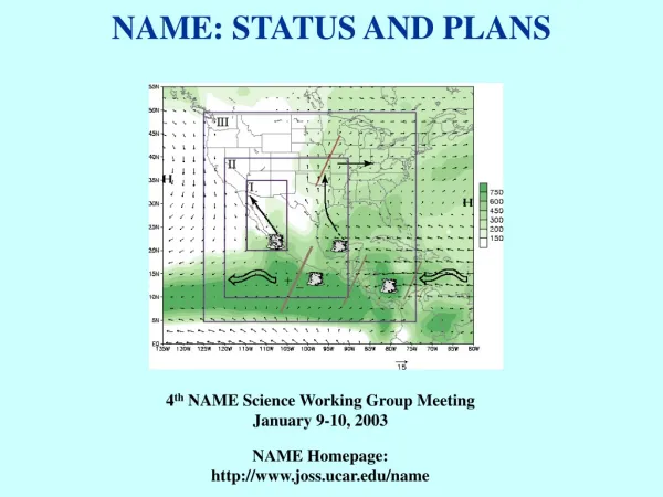
NAME : STATUS AND PLANS NAME Homepage: http://www.joss.ucar.edu/name
OUTLINE • PROGRAM RATIONALE AND OBJECTIVES • LINKAGES (PROGRAMS, AGENCIES, COUNTRIES) • NAME 2004 FIELD CAMPAIGN • NAME MODELING STRATEGY
WHAT IS NAME? NAME is an internationally coordinated, joint CLIVAR – GEWEX process study aimed at determining the sources and limits of predictability of warm season precipitation over North America.
RATIONALE FOR NAME • Global and regional models do not accurately simulate or predict warm season precipitation, especially in tropical / subtropical land-ocean interaction regions. • NAME seeks improved understanding of the key physical processes that must be parameterized for improved simulations and predictions with our models. • A fundamental first step towards improved prediction is the clear documentation of the major elements of the NAMS and their variability within the context of the evolving O-A-L annual cycle.
NORTH AMERICAN MONSOON EXPERIMENT (NAME) HYPOTHESIS The NAMS provides a physical basis for determining the degree of predictability of warm season precipitation over the region. Topographic and Sea-Land Influence • OBJECTIVES: • Better understanding and • simulation of: • warm season convective • processes in complex terrain • (TIER I); • intraseasonal variability of • the monsoon (TIER II); • response of warm season • circulation and precipitation • to slowly varying boundary • conditions (SST, soil • moisture) (TIER III); • monsoon evolution and • variability (TIER I, II, III). Intraseasonal Variability Boundary Forcing? YEAR (2000+) 00 01 02 03 04 05 06 07 08 Planning --------------| Preparations --------------| Data Collection - - - ----------------| Principal Research ----------------------------------| Data Management -----------------------------------------|
NAME IMPLEMENTATION • Empirical and modeling studies that carry forward the joint PACS/GAPPWarm Season Precipitation Initiative (2000 onward), and initiate new elements. • NAME Field Campaign (JJAS 2004) including build-up, field, analysis and modeling phases.
INTERNATIONAL PARTNERSHIPS • SMN Meteorological Infrastructure • 79 synoptic stations • 16 radiosonde sites • 60 automated weather stations (15 more in 2003) • 12 radars (4 in northwestern Mexico) • Historical and real-time data • NAME Forecast Operations Centers (meteorologists,technicians) • (2) Universities and Institutions in Mexico and Central America • UNAM • IMTA • CICESE • University of Costa Rica • University of Vera Cruz • University of Guadalajara • others • Equipment, personnel, transportation, data collection, research
NAME PROJECT STRUCTURE Science Working Group Project Office • NAME Forecast • Operations Centers • NAME International Project • Support Team
NAME AND CLIVAR • NAME is the North American Implementation of the WCRP/ CLIVAR VAMOS Program • NAME is endorsed by the US CLIVAR SSC as a warm season process study of the North American monsoon under theUS CLIVAR Pan American Panel. US CLIVAR’s interests in NAME were listed in the June 2001 meeting report.
RECENT NAME ACTIVITIES • Ocean Processes: • Ocean Component of NAME Workshop (Ensenada, April 21-22) – 3 proposals • Land Surface Processes: • Soil Moisture Field Campaign (NASA Terrestrial Hydrology Program) - funded • NAME Hydrometeorology Working Group (quarterly newsletter) • Modeling: • NAME Modeling - Observations Team: “White Paper” and June 6 “Workshop”on NAME Modeling and Data Assimilation Strategic Plan (global, regional and multi-scale) • NAME 2004: • NAME 2004 Solicitation (May 2003; NOAA PACS/GAPP) • NAME International Project Support Team meeting (May 2003) • NAME Forecast Operations Centers Exchange Visits and Practice Forecasting • NSF Briefing (Tier 1 Observations) • OAR Briefing (Ships and Planes) • NWS Briefing to Regional Directors and Intl. Affairs (NAME FOC) • NAME Special Session and SWG-5 (Nov. 2003, Puerto Vallarta)
NAME AND GEWEX NAME is directly responsive to GEWEX Science Goals • NAME is included in the GEWEX/GAPP Science and Implementation plan, with emphasis on topographic influences on precipitation, hydrology and water resources, and land-surface memory processes. • NAME will contribute to GEWEX’s Cloud System Study (GCSS) by bringing a focus on the effects of complex coastal terrain on precipitating convection into the agenda of GCSS Working Group 4 (Precipitating Convective Cloud Systems).
GAPP - NAME DELIVERABLES NAME Contributions to GAPP: • High resolution precipitation products (e.g. for LDAS, Reg Reanal) • Improved understanding of (i) summer orographic precipitation processes; (ii) the role of land during the monsoon; (iii) the role of the NAMS in the water budget over the region. GAPP Contributions to NAME: • Improved land surface models and coupled land-atmosphere models • LDAS • CEOP • Regional Reanalysis
NAME FIELD CAMPAIGN (JJAS 2004) Enhanced Precipitation Gauge Network R.V. Ron Brown Radiosondes/PIBALS Radar/Profiling/Radiosondes
NAME FIELD NETWORKS (JJAS 2004) Tier I Instrumentation • UHF wind profiler (1) • VISS (5) (SMN sounding+UHF-RASS profiler) • NCAR ISS (4) (UHF-RASS profiler+sounding +sfc) • SMN 5cm Doppler radars (4) (3 Enterprise; 1 Eriksson) • 10cm Doppler-polarimetric radar (NCAR S-POL) • UNOLS shipboard platform (VISS, 5cm Doppler radar, Sfc fluxes) • Mexican Research Vessels • Buoys (ASIS; Aanderra) • NOAA/ETL shipboard flux system (on UNAM/PUMA) • Advanced Lightning Direction Finder (5) • Raingauges (100 event logging; 1600 simple) • Research Aircraft (NOAA P-3, NASA P-3B) • Soil Moisture Sensors Tiers II and III Instrumentation • Radiosonde • PIBAL
TIER I INSTRUMENTATION • SPECIFIC OBJECTIVES: • To describe the daily cycle of convective rainfall over the region; • To clarify relationships between convection and Q-flux from the GOM and the GOC; • To describe the structure/location of precip systems, including MCS’s, within diurnal cycle; • To diagnose mechanisms that force mesoscale rainfall systems for adequate modeling; • To clarify GOC surge / jet / precipitation relationships.
SOUNDING NETWORK (Tiers I-II) SMN Radiosonde Soundings up to 4x daily at 7 sites during IOP’s NWS Radiosonde Soundings up to 4x daily at 9 sites during IOP’s PIBALS up to 4-8x daily, in higher density near Tier 1.
RESEARCH AIRCRAFT OPERATIONS: NOAA P-3 Objective: To measure moisture influx into the NAME tier 1, esp from southern GOC. Technique: Repeatable tracks to provide comparisons with in-situ data [ship and ground-based], model-based analyses and climatology. Frequent profiles (every ~5-6 minutes) between ~100m ASL and 1.5-2 km ASL [50-60 soundings per flight]. Unprecedented spatial resolution across the inflow region at low levels. Number of flights: ~10 flights / ~7.5h per flight. Flights need not be flown in sequence. Same time each day to avoid complications due to diurnal cycle. List of flights: 2 enhanced flux flights, 2 suppresed flux flights, 6 "normal" flux flights, 2 Gulf section flights
EVENT LOGGING RAINGAUGE NETWORK PH 1 Event Raingage (‘02) Isotope Collector PH 2 Event Raingage (‘03) SMN Automatic Met Station Proposed Radar Site SW-NE Transects to sample rainfall gradients from GOC to SMO
NAME Simple Raingauge Network • The network is sparse in large portions of the core and peripheral monsoon regions • NAME will install ~1300 gauges in these regions as a cooperative network to improve monitoring, prediction and assessments.
Tucson Walnut Gulch Three-dimensional perspective in the NAME region looking north from Hermosillo to Tucson Soil Moisture Remote Sensing Field Experiment in NAME • Temporary in-situ soil moisture networks • Aircraft and satellite mapping • Intensive sampling concurrent with aircraft mission Field Campaign Elements
Soil Moisture Remote Sensing Field Experiment in NAME Aircraft and satellite mapping • NASA P-3B should be available July 15 –August 15, 2004 • Satellite sensors: AMSR and TMI • Aircraft sensors: 2DSTAR (L band next generation ESTAR) PSR or AESMIR (AMSR simulators) • Aircraft Mission: • 15 flight dates • 5 hours per day • 50x100 km areas • Walnut Gulch • Mexican site • 4 flightlines
[Director: B. Maddox (Univ. of Arizona)] [Rotational Team Leaders: E. Pytlak (NWS); M. Cortez (SMN)]
EOP and IOP’s for NAME 2004 EOP: June 15-August 31, 2004 IOP's: 20 days during the period tagged to key synoptic features Radiosonde Frequency: EOP : 2x daily (0000Z and 1200Z) Mexico: La Paz, Guaymas, Mazatlan, Chihuahua, Torreon, Zacatecas, Monterrey IOP’s: 4x daily (0000Z, 0600Z, 1200Z, 1800Z) Mexico: La Paz, Guaymas, Mazatlan, Chihuahua, Torreon, Zacatecas, Monterrey United States: San Diego, Las Vegas, Flagstaff, Tucson, Albuquerque, El Paso, Midland, Del Rio, Amarillo The NAME FOC Science Director will be key to decision making relative to the IOPs.
NAME PRACTICE FORECASTING http://www.joss.ucar.edu/name
THE NAME MODELING –OBSERVATIONS TEAM • Charge: • Provide guidance on needs and priorities for NAME 2004 field observations. • “NAMAP” – 6 modeling groups; 1990 monsoon, global and regional models • Identify the path to improved warm season precipitation prediction: • “White Paper” - NAME Modeling and Data Assimilation R&D • “NAME Modeling Workshop (College Park, MD, June 6th) ” • Identify additional process studies necessary to reduce uncertainties in coupled models.
MULTI-SCALE MODEL DEVELOPMENT • Premise: • The leading factors that limit precipitation forecast skill in both global and regional models during the warm season are deficiencies in how we model “local” processes that modulate deep convection. • In order to achieve the desired improvements, NAME will focus on • * moist convection in the presence of complex terrain and • land/sea contrasts; • *land/atmosphere interactions in the presence of complex terrain and land/sea contrasts; • * ocean/atmosphere interactions in coastal regions with complex terrain.
Tier III Objective **Funded NOTE: There are several other funded FY03 PACS/GAPP projects and ongoing PACS/GAPP projects that apply to these objectives. We will link project abstracts to the NAME Webpage together with publications, etc.
MULTI-TIER SYNTHESIS AND DATA ASSIMILATION • Role of Assimilated Data Sets: • To enhance the value and extend the impact of the Tier I observations to address issues of model quality and monsoon variability on larger scales(e.g. out-of-phase relationship between the SW and GP). • 2) To provide an important framework for quantifying the impact of the Tier I observations on the quality of analyses, and for identifying model errors and attributing them to model deficiencies. • Activities: • Regional DAS – NAMS Phenomena (surges, jets) • Global DAS – linkage to large scale; role of remote • boundary forcing • Comparisons to independent data (CEOP)
PREDICTION AND GLOBAL SCALE LINKAGES • Key Issues: • 1) To determine the extent to which model improvements translate into improved • dynamical predictions. • 2) To determine the impact on predictions of improved initial and boundary • conditions. • Some Specific Objectives of NAME Predictability Research: • (Hindcast experiments and NAME 2004 case studies) • 1) To examine whether observed connections between the leading patterns of • climate variability (MJO, ENSO) and the NAMS are captured in global models. • 2) To determine the predictability and prediction skill over the NAMS region • associated with the leading patterns of climate variability. • 3) To investigate the relative importance of oceanic and land-surface • boundary forcing on warm season precipitation prediction.
NAME ROADMAP Key Issue: To ensure a timely two-way flow of information so that the modeling activities provide guidance to the evolving observing program, and that the observations provide information for advancing model development. Pre-NAME 2004 Activities: * Diagnostics and Analysis - Model (e.g. NAMAP; Warm Season Diurnal Cycle in AGCM’s) - Reanalysis (global, regional) * NAME FOC Practice Forecasting * Workshops - NASA/CLIVAR Subseasonal Workshop / NAME Modeling Workshop - NAME SWG-5 / NAME Special Session (Puerto Vallarta) NAME 2004 Activities: * NAME EOP Forecaster Support - Forecast Discussions / Operational Assessments * Real-time Monitoring, Analysis and Forecast Products
NAME ROADMAP Post-NAME 2004 Activities * Model and Forecast System Development - NAME CPT activities (simulation of convective precipitation) - Multi-scale modeling / CRM * Experimental Prediction - NAME 2004 case studies / hindcasts - Sensitivity to SST and soil moisture (operational centers) - Subseasonal prediction (e.g. TISO, MJO) * Diagnostics and Analysis - Reanalysis (global, regional, NAME data impact) - Model diagnostics (NAMAP 2) * Applications and Product Development - Assessments (Hazards, North American drought monitor) - Forecasts (North American seasonal and subseasonal) - Applications (Agriculture, Fire WX, Water Resource) * Research and Dataset Development - PACS-GAPP warm season precipitation initiative
NAME DELIVERABLES • Observing system design for monitoring and predicting the North American monsoon system. • More comprehensive understanding of North American summer climate variability and predictability. • Strengthened multinational scientific collaboration across Pan-America. • Measurably improved climate models that predict North American monsoon variability months to seasons in advance.