Download

1 / 18
180 likes | 356 Views
Dipsea Trail Consensus Route May 25 th 2007 Mile Markers. Start Line Mill Valley. Start Line at the Flag Pole at Lytton Square Lat. N37 ° 54.379’@ Long. W122 ° 32.910’. Dipsea Stairs. Third Tier of the Dipsea Stairs Scheduled for Reconstruction Summer 2007.

E N D
Start Line Mill Valley • Start Line at the Flag Pole at Lytton Square • Lat. N37° 54.379’@ Long. W122° 32.910’
Dipsea Stairs • Third Tier of the Dipsea Stairs • Scheduled for Reconstruction Summer 2007
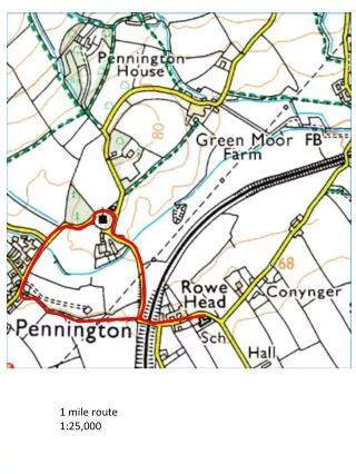
One Mile TreeMile One Marker • One Mile Tree Marker is 5280 ft plus 53 ft from Start line • N37° 53.969’@ W122° 33.593’
Mile Two MarkerRanger’s trail - North of Suicide • 58 ft west from the center of the creek-bed • 12 ft east from the 4 branch tree • N37° 53.540’@ W122° 34.062’
Mile Three Marker The Hogs Back • Mile 3 is at the third intersection of the Fire Road and Dipsea Trail, adjacent to the Bay Area Ridge Trail sign post • N37° 53.507’@ W122° 34.861’
Mile Four MarkerThe Rain Forest • 133 ft west of the Ben Johnson Trail sign • 6 ft west of log cut out crossing trail • 279 ft east of Muir Woods Fire Road sign post • N37° 53.889’@ W122° 35.759’
Mile Five MarkerThe Camel’s Hump • 183 ft west of the old fire road and lone tree • 40 ft west of “Tina’s Sweet Pea” • N37° 53.601’@ W122° 36.574’
Mile Six MarkerSteep Ravine • Mile Six is at the leading edge/ first board of the Webb Creek Bridge • N37° 53.530’@ W122° 37.250’ Approx due to no GPS
Mile Seven MarkerMargaret’s Grotto via the Moors • 66 ft east of the little foot bridge • 809 ft east of the Stile • 5 ft west of the large root in the Trail • N37° 53.778’@ W122° 38.036’
The Finish lineStinson Beach • The Finish Line is 2681ft west of Mile Marker seven. • Total Distance of the race is 7.51 miles to the white line painted at the entrance to the parking lot. • N37° 53.745’@ W122° 38.275’ • Additional photos of the trail follow: