Download
1 / 35
350 likes | 477 Views
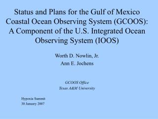
Status and Plans for the Gulf of Mexico Coastal Ocean Observing System (GCOOS): A Component of the U.S. Integrated Ocean Observing System (IOOS). Worth D. Nowlin, Jr. Ann E. Jochens GCOOS Office Texas A&M University Hypoxia Summit 30 January 2007. Outline. Background

E N D
Status and Plans for the Gulf of Mexico Coastal Ocean Observing System (GCOOS): A Component of the U.S. Integrated Ocean Observing System (IOOS) Worth D. Nowlin, Jr. Ann E. Jochens GCOOS Office Texas A&M University Hypoxia Summit 30 January 2007
Outline • Background • Actions to Date in Building GCOOS and its Regional Association 3. Integration of Existing Capabilities 4. Ongoing Developments
Global Ocean Observing System(GOOS) • GOOS is an end-to-end system of observations, data management, and production and delivery of products/services. • GOOS is coordinated by United Nation agencies with the participation of some 100 ocean nations. • GOOS is an element of the Global Earth Observation System of Systems (GEOSS) which also includes the World Weather Watch, Global Atmospheric Watch, Global Climate Observing System and Global Terrestrial Observing System.
The GOOS Modules The Global Ocean Observing System (GOOS) has been designed and is being implemented in two modules: • The global module is designed to monitor, predict, and understand marine surface conditions and climate variability/change; and • The coastal module is designed to sustain healthy marine ecosystems, ensure human health, promote safe and efficient marine transportation, enhance national security, and predict and mitigate against coastal hazards. The U.S. contribution to GOOS is called the Integrated Ocean Observing System (IOOS).
U.S. IOOS Multi – Scale Hierarchy of Observations Global Ocean Climate Component GOOS/GCOS Coastal Ocean Component GLs GoA NE NW MAB Regional Observing Systems SE H Isl C Cal Go Mex S Cal Carrib National Backbone Low Resolution High
Gulf of Mexico Coastal Ocean Observing System (GCOOS) U.S. EEZ Source: USGS http://walrus.wr.usgs.gov/infobank/gazette/html/regions/gm.html
Strategic Values of GCOOS Region • Three trillion dollar annual economy • 1999 population: 46.7 million, increasing about 5% annually • Tourist industry: tens of thousands of jobs worth over $20 billion annually • Commercial fish and shellfish in 2000: 1.8 billion pounds produced with dockside value over $990 million • Shrimp landings in the Gulf: ~80% of the nation's total • Gulf oyster production in poundage: ~60% of the national total • Gulf recreational fishing: ~30% of U.S. saltwater fishing expenditures • Gulf recreational fishing: 23% of U.S. saltwater recreational jobs • U.S. petroleum reserves: 38% are in the Gulf • U.S. natural gas reserves: 48% are in the Gulf • U.S. offshore oil and gas production: 93% is in the Gulf • Seven of the nation's top ten ports in terms of tonnage or cargo value are located in the Gulf of Mexico • Two of the top seven global ports are located in the Gulf
Environmental Challenges • Gulf is the major drainage basin for 33 of the 48 contiguous states. • Gulf is stressed by pollution, nutrient loading, and other problems unique to its ecosystems. • Major ecosystem threats include harmful algal blooms, habitat loss, invasive species, and hypoxic (low oxygen) conditions. • Natural hazards such as hurricanes in summer and extratropical cyclones in winter threaten all strategic activities.
2. Actions to date in building the Gulf of Mexico Coastal Ocean Observing System and Regional Association
GCOOS Workshops & Meetings Held (1) Types: Informational; Sector Needs; RA Structural Integrated Data Systems for Oceanography, 31 October-2 November 2000, Stennis Space Center, MS NVODS Workshop for Managers of Coastal Observing Systems, 14-15 January 2003, Stennis Space Center, MS Exploration of Private Sector Interests in IOOS: Focus on GOM and Southeast U.S. 2-4 March 2004, Houston, TX Harmful Algal Blooms: GCOOS Role in Detection, Monitoring, and Prediction 13-15 April, 2004, St Petersburg, FL Next Steps in the Gulf of Mexico; Needed Underpinning Research 7-8 July 2004, College Station, TX Formation meeting for a GCOOS Education and Outreach Council, 29-30 November 2004, Biloxi, MS Meeting with Pemex, 1 April 2005, Mexico City Initial GCOOS Stakeholder Meeting: Development of a Governance Structure, 24-25 January 2005, New Orleans, LA
GCOOS Workshops & Meetings Held (2) Types: Informational; Sector Needs; RA Structural Initial GCOOS Board of Directors meeting, 25-26 August 2005, Houston, TX GCOOS and the Private Sector: Oil and Gas and Related Industry, 2-4 November 2005, Houston, TX First GCOOS Stakeholder Council Meeting, 10-11 January 2006, Mobile, AL First annual GCOOS Parties Meeting, 11 January 2006, Mobile, AL Meeting of GCOOS Board of Directors, 12 January 2006, Mobile, AL First annual meeting of GCOOS Education and Outreach Council, 24-25 April 2006, Ocean Springs, MS First annual meetings of GCOOS Observing Systems Committee, DMAC Committee and Products and Services Committee, 26-27 April 2006, Ocean Springs, MS Meetings with Mexican Colleagues, 26 June 2006, Mexico City and 27-30 June 2006, Villahermosa GCOOS Board of Directors meeting, 24-25 August 2006, St Petersburg, FL GCOOS-SECOORA Storm Surge and Inundation Workshop, 23-25 Jan. 2007, New Orleans, LA
Resolution to form GCOOS beginning with data sharing and a Mission Statement to guide development of the system were adopted in January 2003.
Observers Web-Page Sensor / Observation ftp NDBC Web-Page NDBC QA/QC Dial-A-Buoy OPeNDAP NWS GATEWAY Global Telecommunications Service Wx. Channel Local Media NODC NCDC NWS Forecast Offices NCEP NDBC MODEM Kit (Meteorological and Oceanographic Data Exchange Module) Regional Observatories Public
Overview of Status of GCOOS Regional Association Formal Memorandum of Agreement establishing Regional Association for governance signed in January 2005; currently 57 signatories. The MoA builds on the GCOOS Mission Statement to provide a management framework for accomplishing GCOOS objectives.
Overview of Status (Continued) Member of the National Federation of Regional Associations Operational structure complete as of April 2006 Business Plan drafted Initial stakeholder priorities for measurements and products under development
3. Integration of Existing Capabilities in the Gulf of Mexico • In situ observations • Satellite observations and products • Model products
Two Guiding Concepts • The Gulf of Mexico Coastal Ocean Observing System is considered to be a "System of Systems" comprised of many sub-systems that may be supported by different entities for a variety of different reasons. • The observations of these various sub-systems will be more useful to GCOOS goals if integrated to produce products needed by other stakeholders.
An inventory of existing operational and product-producing components for the Gulf of Mexico, together with descriptions, costs, out-year budgets, and users is being maintained.
Petroleum Industry current data As of 29 August 2006
Model Products • COAPS Winds and SSH simulations
4. Ongoing GCOOS Development • Further integration of subsystems • Identification of potential user requirements • Enhancements to meet user needs for observations and products (including data management) • Education and outreach
Further integration of sub-systems • We work to bring new (including non-physical) real-time data sets to the NOAA National Data Buoy Center (NDBC) for quality control and open distribution. • We encourage communication among sub-systems through our Observing Systems Committee. • Our Data Management and Communication Committee is developing standards and protocols for use by all sub-systems.
Identification of Stakeholder Requirements • We are working to: – identify observations and products needed by users – estimate economic benefits of these needs – prioritize these needs – plan and initiate pilot projects to enable these needs to be met • Mechanisms used: – Workshops & Meetings • Development of Business Plan • Development of Observing System Plan • Task Team on Public Health
Future Focused Stakeholder Workshops • Fisheries—Commercial, recreational, and regulatory. Seeking assistance from the Gulf of Mexico Fishery Management Council, Gulf States Marine Fisheries Commission, and NOAA Southeast Fisheries Research Center, and state fishery agencies. • Maritime transportation elements—including tanker traffic, container ships, cruise ships, shipping agents, port authorities, pilots, LNG carriers, intercoastal waterway traffic, and commercial transportation of people. • Recreational boating—including marina operators, power squadrons, yacht clubs, marina operators, and retailers. • Urban planners/developers
Public Health • High level of activities on public health have resulted in recommendations • IOOS Public Health Workshop, Jan. 2006 • The Gulf of Mexico Alliance • Standing GCOOS Task Team on Public Health has been created • Terms of Reference call for Team to advise GCOOS Board regarding priority measurements and products
Pilot Projects under Consideration • Instrument volunteer tankers • Open display of water and beach quality measurements • GCOOS Operations Center • Proven three-dimensional circulation model • Measurement and products archive • Probability maps of bottom hazards and maps of hydrocarbon seeps • Improving forecasts of hurricane severity
GCOOS Business Plan • Draft Business Plan for the GCOOS-RA is posted to web for comments • Plan includes • Development strategy • Investment strategy • Near-term priorities for enhancements • Cost estimates • Estimates of economic benefits
Some future 2007 GCOOS Meetings Workshop to plan future research in Gulf between U.S. and Mexico, sponsored by MMS, early 2007 Meetings of GCOOS Board of Directors, Parties, and Stakeholder Council, March 2007, New Orleans Transportation Sector Workshop, 2006, time and venue TBD Meetings of GCOOS Education and Outreach Council and of DMAC, Operating Systems, and Products and Services Committees in April or May 2007 Meetings of GCOOS Board of Directors, August 2007
GCOOS Office Contact Information Worth D. Nowlin, Jr. Ann E. Jochens Project Principal Investigator Regional Coordinator wnowlin@tamu.edu ajochens@tamu.edu (979) 845-3900 (979) 845-6714 Matthew K. Howard Susan R. Martin DMAC Coordinator Research Associate and Webmistress mhoward@tamu.edu srmartin@tamu.edu (979) 862-4169 (979) 845-3900 Website: http://www.gcoos.org Mailing address : Department of Oceanography 3146 TAMU College Station, TX 77843-3146 Fax number: (979) 847-8879
Thank You Please visit our web site for further information. http://www.gcoos.org If you wish to become a Party to the Regional Association, download the Memorandum of Agreement from the GCOOS web site, sign and fax to Worth Nowlin (979) 847-8879.