Download
1 / 19
200 likes | 405 Views
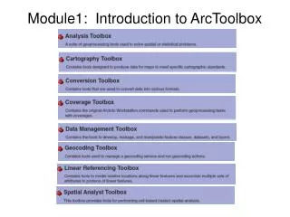
Introduction to ArcToolbox and Geoprocessing. Introduction to ArcToolbox. A series of tools to aid geoprocessing Sequence of operations on geographic data to create new information Examples include: conversion of datasets from one format to another adding a projection

E N D
Introduction to ArcToolbox • A series of tools to aid geoprocessing • Sequence of operations on geographic data to create new information • Examples include: • conversion of datasets from one format to another • adding a projection • buffering around a feature • overlaying datasets
Analysis Toolbox Extract Toolset • Contains tools to extract features and attributes from a feature class and / or table based on attribute queries or spatial extraction • Results are stored in a new shapefile or geodatabase feature class • Tools include: • Clip • Select • Split • Table Select
Analysis Toolbox Extract Toolset Clip Tool • Takes an input layer (points, lines or polygons) + a clipping layer (e.g. polygon of an area) and removes everything outside the clipping layer • Example: input layer is schools for West Yorkshire; clipping layer is boundary of Leeds; output will be schools in Leeds • Example: input layer is buildings in Leeds; clipping layer is a one ward boundary; output will be buildings in the ward
Analysis Toolbox Overlay Toolset • Tools for overlaying multiple feature classes to produce a new feature class that combines information from the individual feature classes • There are several different types of overlay operations but we will look at: • Intersect • Union
Analysis Toolbox Overlay Toolset Intersect Tool • Combines two layers but only keeps those areas that are common to both input feature classes + = INPUT + OVERLAY = OUTPUT
Analysis Toolbox Overlay Toolset Union Tool • Creates a new feature class by combining the features and attributes of both feature classes + = INPUT + OVERLAY = OUTPUT
Analysis Toolbox Proximity Toolset Buffer Tool • Core tool for drawing a buffer around a feature class • Creates buffer polygons to a specified distance around the Input Features with an option to dissolve any overlaps. • Features can be polygons, lines, or points • Combine with overlay to answer queries • Examples: • Crime scene with 2 mile police evidence search boundary • Mobile phone mast with 200 metre danger zone • Schools with 10 mile catchment areas
Analysis Toolbox Proximity Toolset Multiple Ring Buffer Tool • Creates buffer features using a set of buffer distances • Examples: • Store predicts revenue based on a 5, 10 and 20 mile catchment • River flood zone 100, 200 or 300 metres
Analysis Toolbox Statistics Toolset Frequency Tool • Creates a list of unique code occurrences and their frequency
Analysis Toolbox Statistics Toolset Summary Statistics Tool • Calculates summary statistics for field(s) in a table and writes the output to a new table • Statistics include: Maximum, Minimum, Sum, Mean, Standard Deviation, Range, First, Last Drop-down box to select The required statistical function
Data Management Toolbox • Consists of many toolsets and tools but some useful ones are: • General Append • General Merge • Generalization Dissolve • Projections and Transformations Define Projection • Other tools: use the help screen to explore or log a call with your GIS team and they may refer you to one of these tools to help solve your problem
Data Management Toolbox Generalization Toolset Dissolve Tool • Can use this to dissolve overlapping buffers • Can use this to dissolve zones into a higher level • E.g. you have data at postal sector and you want to dissolve to postal area • Need to create a column on which to do the dissolve if this does not exist in your attribute table, e.g. postal area, which contains the first three characters of the postal sector
Data Management Toolbox Projections and Transformations Toolset Define Projection Tool
Work Flows and Model Builder • Work flow = sequence of steps needed to solve a problem • Can put a work flow into Model Builder
Geoprocessing Reference • A good free online guide produced by ESRI can be found here:http://gisgeek.pdx.edu/programming/Geoprocessing_in_ArcGIS.pdf
Using ArcToolbox Hands-on Exercise #10