Vector Geoprocessing
Vector Geoprocessing. Introduction to GIS. Geoprocessing. Geoprocessing is the processing of geographic information. Three general classes of tools. Breaking features into smaller features (e.g. Clip, Intersect, Union). Aggregating features into larger features (e.g. Dissolve,Merge).


Vector Geoprocessing
E N D
Presentation Transcript
Introduction to GIS Geoprocessing • Geoprocessingis the processing of geographic information. • Three general classes of tools • Breaking features into smaller features (e.g. Clip, Intersect, Union) • Aggregating features into larger features (e.g. Dissolve,Merge) • Creating new polygon features through buffering (e.g. Buffer)
Introduction to GIS Geoprocessing Slide courtesy of Leslie Morrissey
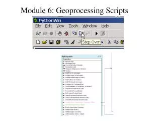
Introduction to GIS Geoprocessing in ArcGIS • Perform geoprocessing in ArcGIS • Run a tool using its dialog box. • Run tools at a command line. • Build and run a model • Create and run a script
Introduction to GIS Geoprocessing in ArcGIS • Perform geoprocessing in ArcGIS • Run a tool using its dialog box. • Run tools at a command line. • Build and run a model • Create and run a script
Introduction to GIS Tools: Geoprocessing • Tools for breaking down the size of map features: • Union, Intersect, Identity, Clip • Tools for increasing the size of map features: • Dissolve and Merge (indirectly) • Arc/Info and Arc Toolbox include various other geoprocessing overlay operations, such as Update and Dissolve Regions
Image source: ESRI Arc Info electronic help Introduction to GIS Union • Combines features of two or several themes • Keeps all line work • Breaks down features, and creates new polygons • Keeps all attributes
Introduction to GIS Tools: Union Polygons only A list of Polygons
Introduction to GIS Find the Geoprocessing Tools
Introduction to GIS Intersect • Yields areas that are common to both layers • Preserves line work within common extent • Usually creates many new, smaller polygons • Preserves all attributes from both
Introduction to GIS Tools: Intersect Two layers
Intersect: Layer 1 + Layer 2 Union: Layer 1 + Layer 2 Introduction to GIS Union vs. Intersection • Union is the union of two overlapping set of features and intersection is the intersection “1 AND 2” “1 OR 2”
Introduction to GIS Union vs. Intersection: Example • Here’s an example. Say we have deer wintering areas in one layer and conserved lands in another.
Introduction to GIS Union vs. Intersection: Example • Union gives us land that is EITHER conserved OR that is a deer wintering areas
Introduction to GIS Union vs. Intersection: Example • Intersect gives us land that is BOTH, and preserves all polygon boundaries within that common extent
Introduction to GIS Identity • Identity performs an intersection but doesn’t retain ALL features • Keeps all “input” layer features • Keeps/creates only overlapping “identity” features and their attributes Kept, as with union Common (intersecting) areas Not kept, as with intersect
Polygon only Point, line, or polygon Introduction to GIS Clip • This uses one theme to “clip,” or serve as the outer boundary of another theme • Breaks down features into smaller units • Preserve the input theme’s attributes
Introduction to GIS Tools: Clip Point, line, polygon Polygon
Introduction to GIS Clipping highways for Merced Note that the “use selected features only” option was used
Introduction to GIS Clipping roads
Introduction to GIS Dissolve • Tool for aggregating polygons—making them bigger. • Single layer operation
Introduction to GIS Tools: Dissolve
Introduction to GIS Dissolve: Example • Dissolve zip codes (small) into counties (large)
Introduction to GIS Dissolve: Example • Choose the dissolve field: e.g. Dissolve based on the County field
Introduction to GIS Dissolve : Example • Summarize the resulting field values. For instance, you could sum population for each county, or average size of ZIP code zones for each county
Introduction to GIS Dissolve : Example • Now we have created a county map, and for each county we have an attribute containing the sum of population of the constituent zip codes
Introduction to GIS Merge • Allows you to “join” two adjacent or non-adjacent themes into the same layer • Like “tiling” • Best when attributes match
Introduction to GIS Tool: Merge
Introduction to GIS Merge • Often when you merge you will want to follow up by dissolving.
Introduction to GIS Tools: Buffering • Buffering is when you draw a polygon around a feature (point, line or polygon)
Introduction to GIS Tools: Buffering Based on distance Based on attribute
Introduction to GIS Tools:Variable Width Buffering
Introduction to GIS Combining Geoprocessing Tools • Involve multiple tasks performed in sequence, such as those that clip, buffer, intersect, union, then select datasets. • Step by step • Build and run a model • Create and run a script
Introduction to GIS Combining Buffering and Geoprocessing: Example • Question: How to find areas that are near deer wintering areas and water bodies but far from traffic? • Geospatial Data • Polygon layer for deer wintering areas • Polygon layer for Water bodies • Roads layer: line features
Introduction to GIS Combining Buffering and Geoprocessing: Example • Question: How to find areas that are near deer wintering areas and water bodies but far from traffic? • “Near” or “Far from”: Buffering • Areas that are near deer wintering areas AND water bodies: Intersect • Combining the layers: Union • Selecting: Query for areas that are not within a traffic buffer
Introduction to GIS Combining Buffering and Geoprocessing: Example • Buffering: Made fixed buffers around deer wintering areas and water bodies, and a variable buffer around roads, based on traffic
Introduction to GIS Combining Buffering and Geoprocessing: Example • Intersecting: The intersection of deer wintering buffers and water buffers (the area in the red)
Introduction to GIS Combining Buffering and Geoprocessing: Example • The union of that intersection with the traffic buffer:
Introduction to GIS Combining Buffering and Geoprocessing: Example • Selecting: Query for polygons that are not within (far from) a traffic buffer
Introduction to GIS Combining Buffering and Geoprocessing: Example • Create a new layer by exporting the selected features (polygons)
Introduction to GIS Geoprocessing Summary Union Intersect Identity Clip Dissolve Merge Buffer