Download
1 / 5
60 likes | 249 Views
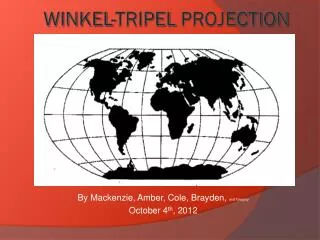
By Mackenzie, Amber, Cole, Brayden , and Gregory October 4 th , 2012. Winkel-Tripel Projection.

E N D
By Mackenzie, Amber, Cole, Brayden, and Gregory October 4th, 2012 Winkel-Tripel Projection
The Winkel-Tripel Projection was created by Oswald Winkel. The “Tripel” in Winkel-Tripel isn't a name but a German term that means a combination of three elements. Oswald picked the name Tripel because he developed a compromise projection. The Winkel-Tripel Projection was created in 1921. http://www.winkel.org/other/Winkel%20Tripel%20Projections.htm
The Winkel-Tripel projection is a map that is usually used for mapping the whole world. While the Winkel-Tripel map usually has very small amounts of distortions it doesn't suffer for any major distortions. According to the Winkel-Tripel website, "The Winkel-Tripel is a compromise projection that is neither conformal nor equivalent." This type of map is very good for general purposing mapping. This map isn't used for mapping anything smaller than the entire planet earth. http://www.winkel.org/other/Winkel%20Tripel%20Projections.htm
The Winkel-Tripel projection doesn’t eliminate area, direction or distance, but shapes are not always shown accurately. The main areas that are distorted in this map are the northern and southern Polar Regions. The scales and area are not equal either. http://www.winkel.org/other/Winkel%20Tripel%20Projections.htm http://www.progonos.com/furuti/MapProj/Dither/ProjMAz/projMAz.html
The Winkel-Tripel projection does not eliminate area or direction and distance it mostly tries to minimize the sum. The Tripel Projection maps the entire world and the lines of latitude are slightly curved. The projection suffers from very little distortion. http://www.winkel.org/other/Winkel%20Tripel%20Projections.htm