Download
1 / 7
70 likes | 228 Views
This guide outlines essential steps in creating a sustainable colony map for the Savannah area before settlement. It emphasizes key city attributes such as well-organized neighborhoods, farming areas, efficient roads, trade access, and safety measures against attacks. The planning process includes drawing a city layout with residential neighborhoods near vital public spaces, roads connecting all areas, and facilitating student participation in voting on the best city plans. Government groups will propose budgets and laws, culminating in community votes to shape the town's governance and infrastructure.

E N D
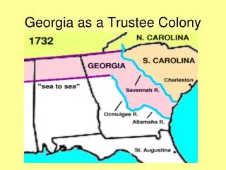
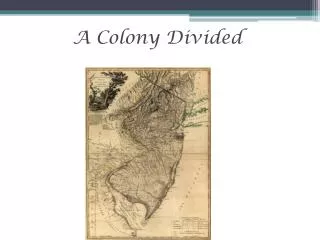
Map of Savannah area before settlement. You should consider the attributes essential for a city: neighborhoods, places for farming, roads, access to trade, safety from attack.
Step 1: Draw a plan for the city Should include: • Residential neighborhoods, roads, business districts and public spaces (parks, city hall, libraries, schools, hospitals). • Residential neighborhoods should be placed near public places, especially schools and hospitals. • Roads should connect areas and should provide multiple alternate routes to avoid traffic jams and bottlenecks.
Step 2: Vote on the best plan • Students will vote on the best plan to implement.
Step 3: Government Groups • Governor and Council • Department of Transportation • Trade Department • Public Safety Department • Residents’ Association • Business Alliance • Education Board • Health Board
Step 3: Government Groups • Each group will create a list of five budget items to spend money on. • Each group will create a list of five new laws to pass.
Step 4: Town Government • Each group will present its requested budget items and its requested laws. • The entire class will vote. • The votes will determine how to allocate the annual budget of $1,000,000.00 and which 20 new laws will make up the town constitution.