Positional Accuracy Assessment
Positional Accuracy Assessment. Pete Aniello. What is ArcGIS Data Reviewer?. Data quality management for ArcGIS. Trusted data through improved quality management. Review. Provides Rule based workflows Interactive tools Track errors For individuals and enterprise Saves time/money

Positional Accuracy Assessment
E N D
Presentation Transcript
Positional Accuracy Assessment Pete Aniello
What is ArcGIS Data Reviewer? Data quality management for ArcGIS Trusted data through improved quality management Review • Provides • Rule based workflows • Interactive tools • Track errors • For individuals and enterprise • Saves time/money • Less rework • Standard extension • ArcGIS for Desktop • ArcGIS for Server Correct Verify
Geospatial Data Accuracy • Spatial (positional, geometric) • Spectral (band depth) • Thematic (classification) • Temporal (appropriate date) • Radiometric (capture piece of electromagnetic spectrum) • Attributional (types of attributes for intended purpose, correctness of attributes)
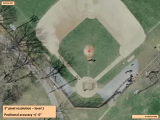
Positional Accuracy • Data needs to be in the “right” place for intended purpose (fitness for use) • All else being equal, less accurate is less valuable • Products usually need to conform to a specification • Usually scale-dependent to some degree • How to quantify? • CE, LE, RMSE
Positional Accuracy Assessment Tool (PAAT) • Part of GIS Data Reviewer • Created with requirements gathered from NGA through the Esri’s CRADA with NGA • Determine accuracy of imagery, rasters, vectors • Quantitative value
Accuracy Reporting • NGA standard or USGS standard • CE 90, 95, 99 • LE 90, 95, 99 (for DEMs or TINs) • RMSE • Absolute or relative
PAAT Outputs • Text report • Metadata • Xml format • ISO • PMAA (NGA) • Accuracy attribute (if assessing vectors) • Shapefile of point reading locations
Demo Positional Accuracy Assessment
Resources • Product page • www.esri.com/datareviewer • Resource Center • http://resources.arcgis.com/ • Training • www.esri.com/training • Questions & comments • datareviewer@esri.com • Questions?
Thank you… Please fill out the session survey: Offering ID: 1855 Online – www.esri.com/ucsessionsurveys Paper – pick up and put in drop box