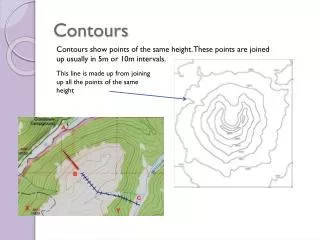
Contours
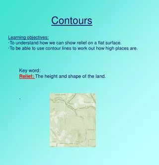
Contours. Learning objectives: · To understand how we can show relief on a flat surface. · To be able to use contour lines to work out how high places are. Key word: Relief: The height and shape of the land. . . Starter How would you describe the relief of the following place?. 2. .

Contours
E N D
Presentation Transcript
Contours Learning objectives: ·To understand how we can show relief on a flat surface. ·To be able to use contour lines to work out how high places are. Key word: Relief: The height and shape of the land. .
Starter How would you describe the relief of the following place? 2. 1. 3. 5. 4. flat high hilly low mountainous
How is relief shown on a map? Relief is shown on maps in three main ways: contour lines spot heights 19 32 37 31 40 46 21 30 14 20 10 12 colour shading. 10-20m 21-30m 31-40m 41-50m
Relief Shading • Relief Map of France. How does it show height?
Contours Relief is often shown on OS maps by light brown/orange lines known as contour lines. Contours are lines that join points of equal height. Contour linesusually have a number attached to them. This number indicates the height of the land above sea-level.
Plenary Match the correct diagram to the correct description. 1. Has two peaks of equal height. 2. Has a steeper slope on the East side. 3. Has a higher peak on the West side. 4. Has one peak. http://www.geographyalltheway.com/in/ks3-maps/showing_height.htm