Understanding Census Geography and Data Collection Process
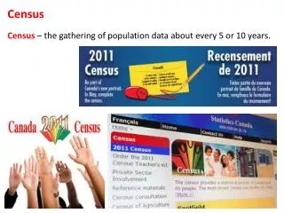
Learn about census basics, history, importance, and Census 2000 & 2010 data. Explore geographic subdivisions like counties, tracts, blocks, and ZCTAs for demographic analysis.

Understanding Census Geography and Data Collection Process
E N D
Presentation Transcript
UP206A: Introduction to GIS Census Basics
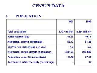
When was the first census? • 1790 • How many people were counted? • 3.9 million • How many states did we have then? • 13 original states, plus the districts of Kentucky, Maine, Vermont, and the Southwest Territory • What questions were asked? • name of head of family • number of persons in each household of the following descriptions: • Free White males 16 years and upward, • free White males under 16 years, • free White females, • all other free persons (by sex and color) and slaves History
When was it taken? • April 1, 2000 • How many people were counted? • 281,421,906 (13.2 percent increase over the 248,709,873 in 1990) • Questionnaire included seven questions for each household: • name • sex • age • relationship • Hispanic origin • race • owner/renter Census 2000
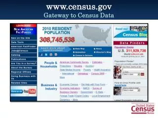
When was it taken? • April 1, 2010 • How many people were counted? • 308,745,538 (9.7 percent increase over the 281,421,906 in 2000) • Questionnaire included ten questions for each household: • http://2010.census.gov/2010census/about/interactive-form.php • Release schedule Census 2010
Apportionment of representatives among the states • census determines how the 435 seats in the U.S. House of Representatives are divided among the 50 states Census 2010
Census data directly affect how more than $300 billion per year in federal funding is allocated to local, state and tribal governments – $3 trillion over a decade. • draw legislative districts • evaluate success of programs or identify populations in need of services Why is the census important?
Before 2010… Short and long…
When was the long form introduced? • 1940 census • How many people got the long form? • 17 percent of the households (1 out of every 6 households) • What questions were asked? • ancestry • income • mortgage • size of the housing unit • disability • etc Long = how we live
Meet the American Community Survey • The form • Replaces the long form • ie, [old long form] = [new American community survey] • From once in 10 years, to every year! (started in 2005) • 1, 3, and 5 year estimates • Which to choose? • http://www.census.gov/acs/www/guidance_for_data_users/estimates/ • You are in luck… the data is JUST becoming available, just in time for your final projects What? No more long form?
counts and basic cross-tabulations of information collected from all people and housing units. • race, age, household size, owner/renter • Lowest level geography: • Blocks Summary File 1
contains tables with social, economic and housing characteristics compiled from a sample of approximately 19 million housing units (about 1-in-6 households) that received the Census 2000 long-form questionnaire. Many tables are given for nine major race and Hispanic or Latino groups. • Lowest level geography: • Block Groups/Census Tracts Summary File 3
UP206A: Introduction to GIS Census Geography
Counties in 48 States • Independent Cities in 4 States • Parishes in Louisiana • Cities and Boroughs in Alaska • 58counties in California • 3,141 counties in the US Counties
Incorporated Places (i.e. municipalities) • Census Designated Places (i.e. unincorporated areas) • 1,081 places in California • 25,150 places in the US Places
Cover the nation (65,000 Census tracts across U.S.) • Relatively homogenous population characteristics • Size: optimally 4,000 people, range between 1,000 and 8,000 • 2,054 census tracts in Los Angeles County • 65,344 census tracts in the US Census Tracts
Groups of blocks (share the same first digit) • Smallest areas for which sample data available • Size: optimally 1,500 people, but range between 300 to 3,000 • 6,351block groups in Los Angeles County • 208,689 block groups in the US Block Groups
Smallest units of data tabulation • Cover the entire nation • Do not cross census tracts or counties • Generally bounded by visible features and legal boundaries • Size: average about 100people • 89,614 blocks in Los Angeles County • 8.2 million blocks in the US Blocks
ZCTAs: ZIP Code Tabulation Areas • Approximate area representations of USPS ZIP Code service areas • Based on Census 2000 blocks • To address difficulties in mapping USPS ZIP Codes • May represent either a five or three-digit USPS ZIP Code • http://www.census.gov/geo/ZCTA/zcta.html ZCTA’s
FIPS – Federal Information Processing Standards 06 037 701400 4 STATE COUNTY CENSUS TRACT BLOCK GROUP FIPS
Topologically Integrated Geographic Encoding and Referencing • developed at the U.S. Census Bureau to support its mapping needs for the Decennial Census and other Bureau programs • coverage of the United States, Puerto Rico, the U.S. Virgin Islands, American Samoa, Guam, the Commonwealth of the Northern Mariana Islands, and the Midway Islands • http://www.census.gov/geo/www/tiger/ Tiger Files
The larger the census geographic unit, the greater the amount of data available (i.e. Single years of data by County) • The smaller the census geographic unit, the less data available (i.e., Age in five-year categories for Census Tracts) Data and Census Geography