Download
1 / 7
80 likes | 340 Views
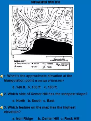
6. In which section of the map is the highest elevation located? a. Northwest b. Southwest. c. East 8. What do the hachure marks around Cedar Sink indicate? a. That it is an area of increased elevation. b. That it is an area of decreased elevation. c. It is an area that will not change.

E N D
6. In which section of the map is the highest elevation located? a. Northwest b. Southwest. c. East 8. What do the hachure marks around Cedar Sink indicate? a. That it is an area of increased elevation. b. That it is an area of decreased elevation. c. It is an area that will not change.
9. There was one month of heavy rain in the hill country. A portion of one of the highest hills broke away and slid down the hill. What is the name of the process that allowed gravity to carry the soil down the hill? a. erosion b. Weathering c. Uplift 10. Which two processes contributed most to the accumulation of soil in this river valley? a. pressure and uplift • b. earthquakes and faulting • c. Erosion and deposition
16. Gravity, ice, wind, and water are all agents of _________ . a. erosion b. abrasion c. deflation