Proterozoic Rocks, Glacier NP
1.3k likes | 1.69k Views
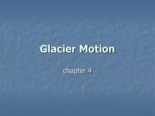
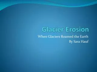
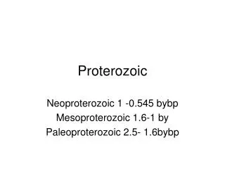
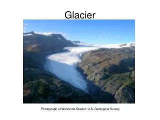
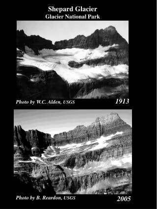
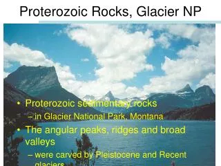
Proterozoic Rocks, Glacier NP. Proterozoic sedimentary rocks in Glacier National Park, Montana The angular peaks, ridges and broad valleys were carved by Pleistocene and Recent glaciers . The Length of the Proterozoic. the Proterozoic Eon alone, at 1.955 billion years long,

Proterozoic Rocks, Glacier NP
E N D
Presentation Transcript
Proterozoic Rocks, Glacier NP • Proterozoic sedimentary rocks • in Glacier National Park, Montana • The angular peaks, ridges and broad valleys • were carved by Pleistocene and Recent glaciers
The Length of the Proterozoic • the Proterozoic Eon alone, • at 1.955 billion years long, • accounts for 42.5% of all geologic time • yet we review this long episode of Earth and life history in a single section
The Phanerozoic • Yet the Phanerozoic, • consisting of • Paleozoic, • Mesozoic, • Cenozoic eras, • lasted a comparatively brief 545 million years • is the subject of the rest of the course
Disparity in Time • Perhaps this disparity • between the coverage of the Proterozoic and the Phanerozoic • seems disproportionate, • but we know far more • about Phanerozoic events • than we do for either of the Precambrian eons
Archean-Proterozoic Boundary • Geologist have rather arbitrarily placed • the Archean-Proterozoic boundary • at 2.5 billion years ago • because it marks the approximate time • of changes in the style of crustal evolution • However, we must emphasize "approximate," • because Archean-type crustal evolution • was largely completed in South Africa • nearly 3.0 billion years ago, • whereas in North America the change took place • from 2.95 to 2.45 billion years ago
Style of Crustal Evolution • Archean crust-forming processes generated • granite-gneiss complexes • and greenstone belts • that were shaped into cratons • Although these same rock associations • continued to form during the Proterozoic, • they did so at a considerably reduced rate
Contrasting Metamorphism • In addition, Archean and Proterozoic rocks • contrast in metamorphism • Many Archean rocks have been metamorphosed, • although their degree of metamorphism • varies and some are completely unaltered • However, vast exposures of Proterozoic rocks • show little or no effects of metamorphism, • and in many areas they are separated • from Archean rocks by a profound unconformity
Other Differences • In addition to changes in the style of crustal evolution, • the Proterozoic is characterized • by widespread rock assemblages • that are rare or absent in the Archean, • by a plate tectonic style essentially the same as that of the present • by important evolution of the atmosphere and biosphere • by the origin of some important mineral resources
Proterozoic Evolution of Oxygen-Dependent Organisms • It was during the Proterozoic • that oxygen-dependent organisms • made their appearance • and the first cells evolved • that make up most organisms today
Evolution of Proterozoic Continents • Archean cratons assembled during collisions • of island arcs and minicontinents, • providing the nuclei around which • Proterozoic crust accreted, • thereby forming much larger landmasses • Proterozoic accretion at craton margins • probably took place more rapidly than today • because Earth possessed more radiogenic heat, • but the process continues even now
Proterozoic Greenstone Belts • Most greenstone belts formed • during the Archean • between 2.7 and 2.5 billion years ago • They also continued to form • during the Proterozoic and at least one is known • from Cambrian-aged rocks in Australia • They were not as common after the Archean, • and differed in one important detail • the near absence of ultramafic rocks • which no doubt resulted from • Earth's decreasing amount of radiogenic heat
Focus on Laurentia • Our focus here is on the geologic evolution of Laurentia, • a large landmass that consisted of what is now • North America, • Greenland, • parts of northwestern Scotland, • and perhaps some of the Baltic shield of Scandinavia
Early Proterozoic History of Laurentia • Laurentia originated and underwent important growth • between 2.0 and 1.8 billion years ago • During this time, collisions • among various plates formed several orogens, • which are linear or arcuate deformation belts • in which many of the rocks have been • metamorphosed • and intruded by magma • thus forming plutons, especially batholiths
Proterozoic Evolution of Laurentia • Archean cratons were sutured • along deformation belts called orogens, • thereby forming a larger landmass • By 1.8 billion years ago, • much of what is now Greenland, central Canada, • and the north-central United States existed • Laurentia grew along its southern margin • by accretion
Craton-Forming Processes • Examples of these craton-forming processes • are recorded in rocks • in the Thelon orogen in northwestern Canada • where the Slave and Rae cratons collided,
Craton-Forming Processes • the Trans Hudson orogen • in Canada and the United States, • where the Superior, Hearne, and Wyoming cratons • were sutured • The southern margin of Laurentia • is the site of the Penokian orogen
Wilson Cycle • Rocks of the Wopmay orogen • in northwestern Canada are important • because they record the opening and closing • of an ocean basin • or what is called a Wilson cycle • A complete Wilson cycle, • named for the Canadian geologist J. Tuzo Wilson, • involves • fragmentation of a continent, • opening followed by closing • of an ocean basin, • and finally reassembly of the continent
Wopmay Orogen • Some of the rocks in Wopmay orogen • are sandstone-carbonate-shale assemblages, • a suite of rocks typical of passive continental margins • that first become widespread during the Proterozoic
Early Proterozoic Rocks in Great Lakes Region • Early Proterozoic sandstone-carbonate-shale assemblages are widespread near the Great Lakes
Outcrop of Sturgeon Quartzite • The sandstones have a variety of sedimentary structures • such as • ripple marks • and cross-beds • Northern Michigan
Outcrop of Kona Dolomite • Some of the carbonate rocks, now mostly dolostone, • such as the Kona Dolomite, • contain abundant bulbous structures known as stromatolites • NorthernMichigan
Penkean Orogen • These rocks of northern Michigan • have been only moderately deformed • and are now part of the Penokean orogen
Accretion along Laurentia’s Southern Margin • Following the initial episode • of amalgamation of Archean cratons • 2.0 to 1.8 billion years ago • accretion took place along Laurentia's southern margin • From 1.8 to 1.6 billion years ago, • continental accretion continued • in what is now the southwestern and central United States • as successively younger belts were sutured to Laurentia, • forming the Yavapai and Mazatzal-Pecos orogens
Southern Margin Accretion • Laurentia grew along its southern margin • by accretion of the Central Plains, Yavapai, and Mazatzal orogens • Also notice that the Midcontinental Rift • had formed in the Great Lakes region by this time
BIF, Red Beds, Glaciers • This was also the time during which • most of Earth’s banded iron formations (BIF) • were deposited • The first continental red beds • sandstone and shale with oxidized iron • were deposited about 1.8 billion years ago • We will have more to say about BIF • and red beds in the section on “The Evolving Atmosphere” • In addition, some Early Proterozoic rocks • and associated features provide excellent evidence • for widespread glaciation
Early and Middle Proterozoic Igneous Activity • During the interval • from 1.8 to 1.1 billion years ago, • extensive igneous activity took place • that seems to be unrelated to orogenic activity • Although quite widespread, • this activity did not add to Laurentia’s size • because magma was either intruded into • or erupted onto already existing continental crust
Igneous Activity • These igneous rocks are exposed • in eastern Canada, extend across Greenland, • and are also found in the Baltic shield of Scandinavia
Igneous Activity • However, the igneous rocks are deeply buried • by younger rocks in most areas • The origin of these • granitic and anorthosite plutons, • Anorthosite is a plutonic rock composed • almost entirely of plagioclase feldspars • calderas and their fill, • and vast sheets of rhyolite and ash flows • are the subject of debate • According to one hypothesis • large-scale upwelling of magma • beneath a Proterozoic supercontinent • produced the rocks
Middle Proterozoic Orogeny and Rifting • The only Middle Proterozoic event in Laurentia • was the Grenville orogeny • in the eastern part of the continent • 1.3 to 1.0 billion years old • Grenville rocks are well exposed • in the present-day northern Appalachian Mountains • as well as in eastern Canada, Greenland, and Scandinavia
Grenville Orogeny • A final episode of Proterozoic accretion • occurred during the Grenville orogeny
Grenville Orogeny • Many geologists think the Grenville orogen • resulted from closure of an ocean basin, • the final stage in a Wilson cycle • Others disagree and think • intracontinental deformation or major shearing • was responsible for deformation • Whatever the cause of the Grenville orogeny, • it was the final stage • in the Proterozoic continental accretion of Laurentia
75% of North America • By this final stage, about 75% • of present-day North America existed • The remaining 25% • accreted along its margins, • particularly its eastern and western margins, • during the Phanerozoic Eon
Midcontinent Rift • Grenville deformation in Laurentia • was accompanied by the origin • of the Midcontinent rift, • a long narrow continental trough bounded by faults, • extending from the Lake Superior basin southwest into Kansas, • and a southeasterly branch extends through Michigan into Ohio • It cuts through Archean and Early Proterozoic rocks • and terminates in the east against rocks • of the Grenville orogen
Location of the Midcontinent Rift • Rocks filling the rift • are exposed around Lake Superior • but are deeply buried elsewhere
Midcontinental Rift • Most of the rift is buried beneath younger rocks • except in the Lake Superior region • where various igneous and sedimentary rocks • are well exposed • The central part of the rift contains • numerous overlapping basalt lava flows • forming a volcanic pile several kilometers thick • In fact, the volume of volcanic rocks, • between 300,000 and 1,000,000 km3, • is comparable in volume although not areal extent • to the great outpourings of lava during the Cenozoic
Midcontinental Rift • Along the rift's margins • coarse-grained sediments were deposited • in large alluvial fans • that grade into sandstone and shale • with increasing distance • from the sediment source • In the vertical section • Freda Sandstone overlies • Cooper Harbor conglomerate, • which overlies Portage Lake Volcanics
Cooper Harbor Conglomerate Michigan
Portage Lake Volcanics Michigan
Middle and Late Proterozoic Sedimentation • Remember the Grenville orogeny • took place 1.2 billion – 900 million years ago, • the final episode of continental accretion • in Laurentia until the Ordovician Period • Nevertheless, important geologic events • were taking place, • such as sediment deposition in what is now • the eastern United States and Canada, • in the Death Valley region of California and Nevada, • and in three huge basins in the west
Sedimentary Basins in the West • Map showing the locations of sedimentary Basins • in the western United States and Canada • Belt Basin • Uinta Basin • Apache Basin
Sedimentary Rocks • Middle to Late Proterozoic sedimentary rocks • are exceptionally well exposed • in the northern Rocky Mountains • of Montana and Alberta, Canada • Indeed, their colors, deformation features, • and erosion by Pleistocene and recent glaciers • have yielded some fantastic scenery • Like the rocks in the Great Lakes region • and the Grand Canyon, • they are mostly sandstones, shales, • and stromatolite-bearing carbonates
Proterozoic Mudrock • Outcrop of red mudrock in Glacier National Park, Montana
Proterozoic Limestone • Outcrop of limestone with stromatolites in Glacier National Park, Montana
Proterozoic Sandstone • Proterozoic rocks • of the Grand Canyon Super-group lie • unconformably upon Archean rocks • and in turn are overlain unconformably • by Phanerozoic-age rocks • The rocks, consisting mostly • of sandstone, shale, and dolostone, • were deposited in shallow-water marine • and fluvial environments • The presence of stromatolites and carbonaceous • impression of algae in some of these rocks • indicate probable marine deposition
Grand Canyon Super-group • Proterozoic Sandstone of the Grand Canyon Super-group in the Grand Canyon Arizona
Style of Plate Tectonics • The present style of plate tectonics • involving opening and then closing ocean basins • had almost certainly been established by the Early Proterozoic • In fact, the oldest known complete ophiolite • providing evidence for an ancient convergent plate boundary • is the Jormua mafic-ultramafic complex in Finland • It is about 1.96 billion years old, • but nevertheless compares closely in detail • with younger well-documented ophiolites
Jormua Complex, Finland • Reconstruction • of the highly deformed • Jormua mafic-ultramafic complex • in Finland • This sequence of rock • is the oldest known complete ophiolite • at 1.96 billion years old
Jormua Complex, Finland • Metamorphosed basaltic pillow lava 12 cm
Jormua Complex, Finland • Metamorphosed gabbro between mafic dikes 65 cm
Proterozoic Supercontinents • You already know that a continent • is one of Earth's landmasses • consisting of granitic crust • with most of its surface above sea level • A supercontinent consists of all • or at least much of the present-day continents, • so other than size it is the same as a continent • The supercontinent Pangaea, • which existed at the end of the Paleozoic Era, • is familiar, • but few people are aware of earlier supercontinents