Attribute databases
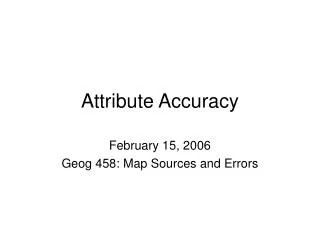
Attribute databases. GIS Definition Diagram. Output. Query Results. Query Results. How do attribute databases allow analysis? GIS can be used to query the data and and answer questions. What is an attribute database? - data grouped together or related to a common subject

Attribute databases
E N D
Presentation Transcript
GIS Definition Diagram Output Query Results Query Results
How do attribute databases allow analysis? GIS can be used to query the data and and answer questions. What is an attribute database? - data grouped together or related to a common subject that can be analyzed. ie. Attribute data on fire hydrants: id#, address, year installed, diameter, year flushed, color, type, etc.
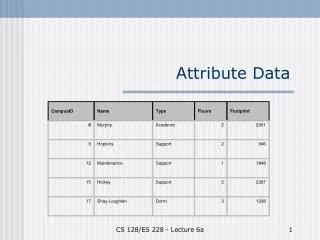
Attribute table consists of: Record- One row in the table that shows values of a group of related items. All records are the same length (ie. Owner records are all Character & 38 characters wide) Field- Defines where a particular type of data can be found. Also referred to as a variable or column. - A Key field is a designated field used to locate or sort records. - There be more than one key field. - There is usually a unique key field (no duplicate values). What is the unique key field in this example? field record Parcel or Property table
Databases have developed / evolved to manage and query data • ASCII, hierarchical, network, relational, object-oriented • Most GIS software use relational databases • What is a relational database? • Definition: • Tables of data items that are linked and logically related. • Consist of a DBMS (Data Base Management System) • that is used to manage and manipulate the data.
How does a GIS use relational databases? - GIS can perform data selection through searches (queries) - Computer language used to ask the questions: SQL- Structured Query Language User selects menu options to generate the SQL (User does not need to type or understand the actual SQL syntax)
Simple selection (query) from one table: Queries can be performed on single or multiple tables using one or more fields
Queries can be more complex using more than one table: How could I generate a student list for a course?
Generating a student list for a course from multiple tables: link link Result is Selection/ Query Table This procedure is known as a relational join: two or more tables are linked together by common fields. The resulting table is known as a “selection” or “query” table. The query table is a temporary table- You can save the query table results to a new table, save the query syntax, or discard the table.
Attribute queries have been used in traditional relational databases for years. Examples of relational database software packages are: dBase, Oracle, Access, MySQL (web), PostgreSQL (web) GIS packages can link directly to the relational db: In MapInfo, look under File> Open DBMS table What makes GIS packages unique in handling relational Databases is the ability to LINK THE ATTRIBUTE QUERY RESULTS TO THE SPATIAL OBJECT AND VISUALLY DISPLAY ON THE MAP
Any db package can perform attribute queries, but GIS allows an additional step , by linking query results to the spatial objects on the map.
Select attribute record in table. The spatial object is highlighted on map. Select the spatial object on map. The attribute record in table is highlighted.
To query data in MapInfo, use Query> Select for simple selections Or Query> SQLSelect for more complex selections. Shown below is the Query> SQLSelect screen from MapInfo with a brief description of the options.