Download
1 / 1
10 likes | 113 Views
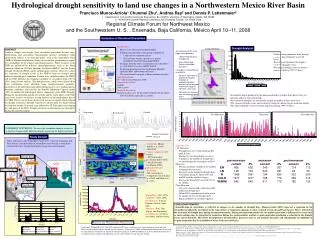
Evaluate streamflow impacts of land use changes in Yaqui River basin under different climate regimes. Study uses wavelet analysis to assess drought sensitivity to agricultural and afforestation practices.

E N D
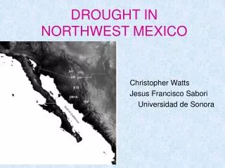
Hydrological drought sensitivity to land use changes in a Northwestern Mexico River Basin • Francisco Munoz-Arriola1 Chunmei Zhu1, Andrea Ray2 and Dennis P. Lettenmaier2 • Department of Civil and Environmental Engineering, Box 352700, University of Washington, Seattle, WA 98195 • NOAA Earth System Research Laboratory, 325 Broadway, Boulder, CA 80303-3328 • Regional Climate Forum for Northwest Mexico • and the Southwestern U. S., Ensenada, Baja California, México April 10–11, 2008 Oviachi SOI 1 2 1 4 16 0.5 Period PDO Cross Wavelet Transform Squared Wavelet Coherence 1 0 2 4 Squared Wavelet Coherence 16 1955 1965 1975 1985 1995 Evaluation of Simulated Streamflow VIC Features: • Macro-scale and semi-distributed model • Subgrid representation of the spatial variability in: • Land surface vegetation classes • Soil moisture storage capacity as a spatial probability function (Xinanjiang Model) • Drainage from the lower soil moisture zone (baseflow) as a non linear recession (ARNO model) • Evapotranspiration based on the Penman-Moneith equation (Mid- and bottom soil layers) • The routed runoff transport is linear and time invariant • Spatial Resolution: • 1/8 o (Zhu and Lettenmaier, 2006) • Temporal Resolution: • 3-hourly • 1949 to 1999 • Temporal Resolution • Drought analysis uses the percentile method with the lower 20% threshold (Andreadis et al 2006) Drought Analysis ABSTRACT Land-use changes can strongly affect streamflow generation. In most cases, deforestation and agricultural intensification increase streamflow while afforestation reduces it. In semi-arid basins, such as the Yaqui River basin (YRB) in Northwestern Mexico, changes in streamflow generation may impact the sustainability of the region's agricultural practices. Water resources in the YRB are influenced by different climate-phenomena, such as the North American Monsoon, El Niño Southern Oscillation (ENSO), and the Pacific Decadal Oscillation (PDO), and by anthropogenic activities. Here we evaluate the sensitivity of drought events in the YRB to land use changes under different climatological conditions. Periods were identified where the ENSO and the PDO influence the temporal variability of streamflow from 1949 to 1999, using wavelet analysis. The drought events, which were influenced by these oscillations, were identified using runoff-percentile anomalies. Increments of the agricultural and afforestation practices were implemented as boundary conditions, and used by the Variable Infiltration Capacity model (VIC) to simulate the hydrological surface components of the YRB. Droughts during the non-monsoon months of La Niña and the warm phase of the PDO years were sensitive to increase in crop land-use in the northernmost part of the YRB. The rest of the basin observed an increase in runoff, which reduced the drought occurrence. Drought sensitivity to afforestation was higher during the monsoon months. In neutral years followed by El Niño and in years during the cold phase of the PDO, drought sensitivity to afforestation was the highest during the monsoon months. • An increment of 3% in the crop surface produces • Streamflow decrease in Angostura • Paso Nacori and Oviachi streamflow increases • Changes in streamflow are associate to: • Deficit in soil moisture and the consequent inhibition of evapotranspiration previous to the monsoon and the first stage of monsoon (June-July) • Soil moisture increment after the monsoon onset favors evapotranspiration • Under current conditions short draught events (5 days) dominate in all sub-basins • Paso Nacori experiment the highest number of draught events • The largest drought event occurred in Angostura during 1999 (79 days) • Streamflow deficit produced by the monsoon droughts is higher than those in the pre-monsoon and post monsoon months. • Post-monsoon droughts are consistently smaller in number of days and events • The strongest drought events and occurred at Angostura during the pre-monsoon months • The largest drought event occurred in Angostura during 1999 (79 days) Stream Flow (106 cfs) Angostura Oviachi Paso Nacori Pre-Monsoon Monsoon Post-Monsoon STATEMENT OF PURPOSE: To assess the streamflow drought sensitivity to land use changes under different climatic regimes in the Yaqui river basin Simulated (naturalized Study Domain Observed Three sub basins of the Yaqui River basin were evaluated, Angostura and Paso Nacori, considered natural streamflows and Oviachi a streamflow diverted for water storage (hydropower generation and irrigation). • Calibration: Munoz-Arriola et al. (to be submitted) • Climate conditions: (see below) • El Niño Souther Oscillation Index (SOI) • Pacific Decadal Oscillation (PDO) • Identification and Evaluation • Wavelet Analysis • Composites (from Larkin et al 2002 and Mantua et al. 1997) • Angostura Case • Pre Monsoon • Drought days were reduced during EN and LN years • During N years draught days increases • Changes in the number of draught days occurred during the warm phase of PDO • Monsoon • During all climate conditions the number of drought days increases • Increases in the number of drought days were higher during N, followed by LN, and EN with the smallest changes • During the Warm PDO occurred 92% of the changes • Non-Monsoon • All years experimentd a reduction in the number of drought days • Warm PDO experimented a reduction in the number of days of drought while during cold PDO occurred the opposite Bavispe River Angostura Paso Nacori NAMS Sonoran Desert Moctezuma River Gulf of Mexico Sierra Mafre Occidental Gulf of California Aros-Papigochi River Oviachi Pacific Ocean Yaqui River Yaqui Valley Gulf of California Warm PDO: (1947-1976) Cold PDO: (1977-1995) Pre-Monsoon: (January, February, March, April, May) Monsoon: (June, July, August, and September) Post-Monsoon: (Octuber, November, and December) • CONCLUDING REMARKS • Intensification in agriculture is reflected in changes in the number of drought days. Munoz-Arriola (2007) observed a reduction in the streamflow produced by increments in the crop surface at Angostura (opposite to what occurred at Oviachi and Paso Nacori). This is reflected in the increment of drought days during the monsoon months. During non-monsoon months the streamflow generation is influenced by events such as snow melting (may be important in Angostura during the spring months) and low evapotranspiration producing a reduction in the drought events and its duration. This shows the importance of land surface processes such ass soil moisture dynamics and consequently the inhibition of evapotranspiration due to availability of water in the first soil layers. Small- mid- (El Niño [EN], La Niña [LN], and neutral [N] years), and large-scale clime conditions (warm and cold PDO)were identified using the squared wavelet coherency (Grinsted et al. 2004) and information in literature, observed in the climatological composites of simulated streamflow (Larkin et al 2004 and Mantua et al 1997). Monsoon months were assumed June, July, August, and September, the rest of the months are non-monsoon months. Andreadis, K.M. and D.P. Lettenmaier, 2006: Trends in 20th century drought over the continental United States, Geophys. Res. Lett. , 33, L10403, doi:10.1029/2006GL025711 Larkin, N. K., and D. E. Harrison (2002), ENSO warm (El Nino) and cold (La Nina) event life cycles: Ocean surface anomaly patterns, their symmetries, asymmetries, and implications, J. Clim., 15, 1118-1140. MunozArriola, F., D. Lettenmaier, C. Zhu..and R. Avissar. Hydrological Response to Land Use Change in the Yaqui River Basin (submitted, Water Resources Research) Munoz-Arriola, F. (2007). Hydrological Response to Precipitation Discrepancy and Land Use Changes in the Yaqui River Basin. Civil and Environmental Engineering Department, Duke University. Ph. D. degree inCivil and Environmental Engineering. Zhu C.M. and D.P. Lettenmaier, 2007: Long-term climate and derived surface hydrology and energy flux data for Mexico,1925-2004, Journal of Climate,20, 1936-1946.