Download
1 / 19
190 likes | 293 Views
This document discusses the intellectual property developed by Gary Wockner and Randy Boone, focusing on a model addressing the impacts of energy extraction on game animals in Colorado. It highlights the rapidly increasing number of oil and gas permits and the associated wildlife challenges. The model employs scientific studies to project forage deficits caused by the avoidance behavior of ungulates near drilling sites. Additionally, it proposes quantified on-site and near-site mitigation strategies to counterbalance the effects of energy infrastructure on wildlife habitats.

E N D
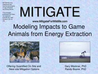
MITIGATE is the intellectual and commercial property of Gary Wockner and Randy Boone.The prototype presented here does not represent scientifically valid research. Do not cite. MITIGATEwww.MitigateForWildlife.com Modeling Impacts to Game Animals from Energy Extraction Offering Quantified On-Site and Near-site Mitigation Options Gary Wockner, PhDRandy Boone, PhD
Oil and Gas Extraction in Colorado • 2,917 permits in 2004 • 4,363 permits approved in 2005 • … and at a record-breaking pace this year. • 3.37 billion cubic feet of natural gas per day • Royalties and rentals from state land contributed $41.7 million to the state in fiscal 2005. • Counties collected $227 million in property taxes from mineral interests. • Some wells are in sensitive wildlife areas, or in areas where the local economy is highly dependent on hunting revenues. Chakrabarty, RMNews, April 18, 2006
Oil and Gas Wells in Coloradoblack dots = active wells (March 2006, more since)green lines = county boundaries
MITIGATE Prototype/Proposal: GMUs 22 and 31,Piceance Basinblack dots = active wells (March 2006, more since then)green lines = county boundariesblue lines = GMU boundaries GMU 22GMU 31
MITIGATE Scientific Antecedents MITIGATE relies on two scientific antecedents: • Studies that use GIS layers to predict forage-based carrying capacity for ungulates a. Teton/NER (carrying capacity and forage deficits) b. HPP, Habitat Assessment Model (carrying capacity) c. Great Sand Dunes (carrying capacity) d. Various Savanna ecosystem model applications 2.Studies that predict (through animal collaring and observation) the degree of “avoidance” of habitat by wild ungulates in the vicinity of oil and gas wells. • Sublette Mule Deer Study, Wyoming • Alaska oil fields and caribou
Wildlife Avoidance of Gas/Oil Wells Studies An extensive literature review will be conducted during ongoing research. For this demonstration, we used the best source available, Sawyer et al. (2005), which collared and observed mule deer to find avoidance distances near oil and gas wells.
Sublette Mule Deer Study (Phase II) 2005 Annual Report Sawyer et al., Western Ecosystems Technology, Inc. “Changes in habitat selection by mule deer appeared to be immediate (i.e., Year 1 of development) and through 3 years of development, we found no evidence they acclimated or habituated to well pads.” “Rather, mule deer had progressively higher probability of use in areas further away from well pads as development progressed; preferring areas 2.7, 3.1, and 3.7 km away from well pads in Years 1, 2, and 3, respectively.” “Interestingly, the model from Year 4 did not contain the distance to well pad variable and mule deer habitat was not influenced by proximity of well pads.” “This distribution pattern probably reflects the heavy snow conditions during Year 4 (2003-04); the most severe winter since this study began in 1998.”
MITIGATE PROPOSAL/PROTOTYPE STUDY AREAGMUs 22 and 31, Western Colorado One Version of Proposed Model Process1. Calculate forage production in GMUs.2. Define “buffer areas” around drill pads inside of which elk/deer avoid.3. Predict “forage deficits” due to “avoidance” ofdrilling pads by elk/deer using a buffered approach. Equal to an estimate of forage (in millions of pounds) that must be restored to offset forage deficits due to energy extraction. 5. Offer quantified on-site, near-site, or off-sitemitigation options.
Range Vegetation Production • Range vegetation production fromUSDA/NRCS SSURGOdatabases and adjusted for local conditions. • Other more refined techniquescan be used to estimate forage production dependingon resources.
Direct Loss of Habitat From Road Building and Drill Pad Construction (not directly used in MITIGATE) Satellite image of zoomed-in area Area with roads and drill pads highlighted
Do Not Cite. Buffer Avoidance Distances 500 meters 1000 meters 2000 meters 3000 meters 6.2% 17.8% 40.1% 56.2%Percent of Range Vegetation Inside Buffers(GMUs 22 and 31)
Range Vegetation Within Buffer Distances Around Drill PadsRange vegetation amounts are from a mean precipitation year. GMU 22 GMU 31 Per Elk/Deer ComparisonElk forage requirement = 10 lbs/dayDeer forage requirement = 3 lbs/day 1 million pounds forage feeds 274 elk or 914 deer for 12 months
Forage Deficit Modeling for Wild Ungulates in GMU 22(~10% of vegetation production inside buffer) Deficit in pounds: 500 m = 2.9 mil, 1000 m = 8.5 mil, 2000 m = 19.3 mil, 3000 m = 27 mil
On-Site/Near-Site Mitigation Options • Given the quantified estimate of forage deficits due to avoidance, MITIGATE can estimate the following mitigation options needed to offset overgrazingand forage deficits within a study area: • The amount of supplemental feeding (hay bales, aerial-applied pellets, etc.). • The numbers of livestock that must be taken off the area. • The acreage and type of habitat improvement (seeding, irrigation, etc.). • The improvements to gas extraction methods needed to decrease buffer areas (fewer well pads, BMPs, minimize human presence, etc.). • The acreages of local hay fields that must be purchased or leased. • Or some combination of 1 – 5. Example, Option 5:Purchase/Lease Local Hay Fields Mapped Hay Fields in Highlighted Area of GMU 31
Quantifying On-Site or Near-Site Mitigation Options As an example, if the forage deficit was 19.3 million pounds (roughly equal to a buffer range of 2,000 meters in GMU 22), that would require one of the actions below, or some combination of these actions: • 386,000 fifty-pound bags of feed, or the equivalent in hay bales (needed every year). • Removing 3,304 cattle or 20,337 sheep from the GMU. • Irrigating or seeding at least 9,650 acres of dry land to increase production from 1,000 lbs/acre to 3,000 lbs/acre (best case scenario). • Improving oil/gas extraction methods so that buffers shrink as much as possible, and then mitigating the remaining forage deficits through another approach. • Buying/leasing 6,433 acres of irrigated hayfields, and making those fields available to migrating wildlife, or driving the wildlife to those fields. Not valid research. Do Not Cite.
3000 Meter Buffer Around All Gas/Oil Wells in ColoradoMarch 2006
MITIGATE Research Method Options • The previous slides represent a prototype method of determining and mitigating impacts of oil/gas disturbance on big game herds. Many additional factors and methods could be added to increase rigor and functionality, such as: • Modeling animal migrations and distributions on a finer spatial and temporal scale. • Collaring and observing elk/deer in study areas to see if behavior is different than in Wyoming (possible difference in vegetation, topography). • Modeling habitat selectivity of different ungulate species – differing forage selection by elk/deer/pronghorn. • Using a “well type” variable to indicate whether the well is in the drilling or pumping phase (drilling creates a larger buffer). • Adaptations: • 1. MITIGATE could also be adapted to study other species of concern such as sage grouse.
Research Expertise and Availability • Gary Wockner and Randy Boone offer MITIGATE as one option in a toolbox of skills that can address the impacts on wildlife from energy extraction. The prototype slideshow is intended to stimulate discussion and research/contract opportunities, rather than be a sole approach/method. Around the impacts on wildlife of energy extraction, we can: • Direct and broker natural resource information for agencies or companies • Guide, administer, and conduct research at the basic or applied level • Build software tools (MITIGATE could be a stand-alone software package that was re-run every year in a GMU as energy extraction proceeded.) • Offer services through commercial contract or university-based researchResumes and Work HistoryGary Wockner: www.nrel.colostate.edu/people/gwockner (970) 218-8310Randy Boone: www.nrel.colostate.edu/~rboone (970) 381-0538 • Past clients have included: Colorado Division of Wildlife, U.S. Bureau of Land Management, U.S. Geological Survey, U.S. National Park Service, U.S. Fish and Wildlife Service, U.S. Agency for International Development, U.S. National Science Foundation, U.S. National Oceanic and Atmospheric Administration, International Livestock Research Institute (Kenya), Food and Agriculture Organization (Italy).