Download
1 / 28
280 likes | 369 Views
This project converted utility boundary data into a statewide GIS layer with high accuracy using MapWiki collaboration. Participants resolved 176 anomalies successfully within project schedule, delivering results on time and on budget. The innovative approach combined mapping and wiki technologies for seamless collaboration and efficient data entry.

E N D
PROJECT MAPWIKIS THE INDIANA UTILITY BOUNDARY EXPERIENCE
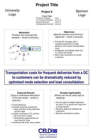
Project Description • Convert utility boundary and attribute information from 698 IURC “Facet” Maps into a single statewide GIS layer. • Map sources include paper and mylar maps, Shapefiles and AutoCAD files. • Deliver the new GIS layer in an ArcGIS 9.1 Geodatabase format. • Achieve 100% accuracy for utility boundaries and a 98% accuracy for boundary attributes. • Complete the project in 9 months.
The Challenge“A Key to the success of this project is to realize that it is not only technical data entry, but also the resolution of conflicting boundaries.” How to: • Provide continuous updates on the status of the conversion process, and • At the same time provide a means for resolving boundary errors and disputes, and • Do this while staying within our project schedule
What is a Wiki ? Ward Cunningham defined a Wiki as “the simplest thing that could possibly work.” The minimal software necessary for online collaborative communication. Cunningham went on to describe a Wiki as “a work sustained by a community.”
Jimmy WalesCreated Wikipedia - 2001 • 11th most visited website in the world
General Wiki Content • General Wiki information included: • Map Instructions • Wiki Instructions • Flag Page Instructions • Utility ID and Name Index • Map and Wiki Navigation Instructions
Specific Wiki Content • Project specific Wiki information included: • Bi-Weekly Progress Reports • Meeting and Delivery Announcements • Data Acceptance Reports • A Specific Flag Resolution Page for each Boundary Anomaly Identified
MapWiki Results • The MapWiki was set up and operating within two weeks of the project start date. • The MapWiki allowed 122 separate organizations to collaborate successfully using the Internet on a complex statewide GIS project. • During the course of the project 176 boundary anomalies were identified and resolved with no significant delays to the overall project. • The project was completed on time and on budget.
Completed Statewide Electric UtilityBoundary Layer - December 2006