Download
1 / 59
590 likes | 736 Views
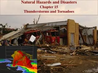
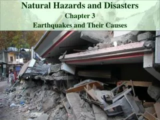
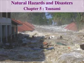
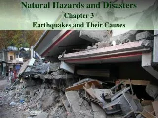
Natural Hazards and Disasters Chapter 3 Earthquakes and Their Causes. Earthquake Devastates South Asia. October 8, 2005: violent earthquake in Pakistani Kashmir Buildings collapsed, crushed by landslides, boulders from steep mountainsides

E N D
Natural Hazards and Disasters Chapter 3 Earthquakes and Their Causes
Earthquake Devastates South Asia • October 8, 2005: violent earthquake in Pakistani Kashmir • Buildings collapsed, crushed by landslides, boulders from steep mountainsides • Highways and roads closed by rockfalls and landslides • Delays in relief, repairs: many died over following cold winter • In all, 87,000 people died, tens of thousands injured, 3.5 million people lost homes
Faults and Earthquakes Faults: fractures in crust along which rocks on one side move past rocks on the other side Measured according to amount of displacement: over several million years, west side of San Andreas fault has moved about 450 km to north Some faults produce earthquakes when they shift, others produce almost none Most faults along plate boundaries Few faults in stable interior regions of continents
Three Types of Faults Normal faults Reverse faults Strike-slip faults
Faults and Earthquakes • Normal faults • Crustal extension • Rocks above steeply-inclined fault surface slip down past rocks beneath fault surface Hanging Wall Footwall
Faults and Earthquakes • Reverse faults • Crustal compression • Rocks above steeply-inclined fault surface slip up and over rocks beneath fault surface • Thrust faults are same as reverse faults, but have much less steeply-inclined surface Hanging Wall Footwall
Faults and Earthquakes • Strike-slip faults • Vertical surface • Rocks on one side of fault slip laterally past rocks on other side of fault • Where rocks on far side of fault slip to right: right-lateral strike-slip fault • Where rocks on far side of fault slip to left: left-lateral strike-slip fault
Causes of Earthquakes • Abraham Himmelwright and the post-disaster building survey • Social vulnerability and building codes matter Commission appointed after great San Francisco earthquake of 1906 to find cause of earthquakes, headed by Andrew Lawson Lawson and students had mapped San Andreas fault (SAF), but had no idea it caused earthquakes After 1906 earthquake, they found that west side of SAF had shifted north by as much as 7m
Causes of Earthquakes Commission theorized that the two sides of SAF had been stuck for years, accumulating energy, while surrounding areas shifted Stuck segment of fault finally slipped, released energy in form of earthquake Elastic rebound theory
Causes of Earthquakes Stress: forces imposed on rock Strain: change in shape of rock, in response to stress Rocks deform elasticallyunder low stress: revert to former shape when stress is removed Rocks deform plasticallyunder high stress: permanently change shape or flow Fault ruptures under brittle failure
Causes of Earthquakes Size of earthquake is related to amount of movement on fault, in terms of offset and rupture length Offsetis distance of movement across fault Surface rupture length is total length of break
Causes of Earthquakes • Some faults move continuously, rather than suddenly snapping • Strain is released by creep • Slow, more or less continuous movement occurring on faults due to ongoing tectonic deformation. Faults that are creeping do not tend to have large earthquakes(USGS) • Central SAF undergoes creep • Hayward fault in northern California undergoes creep and generates large earthquakes
Tectonic Environments of Faults • Earthquakes and faults are associated with plate boundaries • Sense of motion across fault is dictated by relative motion across plate boundary • Strike-slip faults along transform boundaries • Thrust faults and reverse faults along convergent boundaries • Normal faults along divergent boundaries
Notice Something? 316,000
Transform Faults • San Andreas Fault • Continental transform fault marks relative motion between Pacific plate (moving northwest) and North American plate (moving slightly south of west) • Movement between plates would generate several magnitude 7 earthquakes in century – usually occur in clusters
Transform Faults • San Andreas Fault • Compression of Los Angeles basin (at bend in SAF) produces blind thrusts – do not break surface • Reverse faults below the surface • Seventeen earthquakes greater than magnitude 4.8 hit Los Angeles between 1920 and 1994, from thrust faults and blind thrusts adjacent to SAF • SAF south of Parkfield has been stuck since 1857 Fort Tejon earthquake
Blind Thrust Faults Glacier National Park
Subduction Zones • Largest earthquakes on record, including • 1960 Chile, magnitude 9.5 • 1868 Peru, magnitude 9 • 2001 Peru, magnitude 8.4 • 2007 Peru, magnitude 8.0 • 2004 Sumatra, magnitude 9.1, generated megatsunami • 2007 Sumatra, magnitude 8.4
Subduction Zones Absence of large earthquakes along Cascadia subduction zone in Pacific northwest worried seismologists Record now shows that large earthquakes occur there every few hundred years
Continental Spreading Zones • Basin and Range of Nevada • North-trending normal faults separate raised mountain ranges from down-dropped valleys • Eastern margin is Wasatch Front, edge of Salt Lake basin • Many small earthquakes, but no large ones since Salt Lake City founded in 1847 • Fault zone capable of generating magnitude 7 earthquakes
Intraplate Earthquakes • Within-plate earthquakes • New Madrid, Missouri: December 1811, January 1812, February 1812 • Great earthquakes felt as far as Boston • 18th, 19th, and 20th largest earthquakes in the U.S., and the only three of four on the top 20 list that did not occur on the west coast
Intraplate Earthquakes • The Humboldt Fault, part of the Midcontinent Rift System • Largest Kansas earthquake ever? • Near Wamego, 1867, 5.5 • Less than a 3% chance of a 7.0 or higher, which would rupture the dam if the focus were close enough
Intraplate Earthquakes • Charleston, South Carolina, 1886 • East Coast fault system • Buried boundary between Piedmont continental crust and Atlantic oceanic crust • Eastern U.S. earthquakes less frequent, but more widely felt • Older, stable crust that transmits earthquake wave energy more efficiently
Intraplate Earthquakes Dec. 25 2010 http://www.redorbit.com/news/science/1971244/odd_earthquakes_not_letting_up_in_central_arkansas/index.html
Earthquake Waves • When fault slips, released energy travels outward in seismic waves • Outward from point on fault that first slipped: focus(or hypocenter) • Epicenteris point on surface of Earth directly above focus
Types of Earthquake Waves • Wave terminology • Period: time for one complete cycle between successive wave peaks to pass • Wavelength: distance between wave crests • Amplitude: amount of positive, negative wave motion • Frequency: number of peaks per second
Types of Earthquake Waves • Four types of earthquake waves • P-Waves • S-Waves • Rayleigh Waves • Love Waves • You’ll view animations of each of these in today’s lab
Types of Earthquake Waves • First arrival is P wave (P = Primary, first) • Compressional motion • Feels like sudden jolt • Travels at 5-8 km/s through rock • Sometimes heard as low rumbling
Types of Earthquake Waves • Second arrival is S wave (S = Secondary) • Shear motion • Feels like wiggling, difficult to stand • Travels at 3.5-4.5 km/s through rock • More destructive than P waves • Both P and S waves are body waves
Types of Earthquake Waves • Last arrivals are surface waves • Include Love and Rayleigh waves • Long, rolling motion • Travel slower than P or S waves • Can be more destructive than P or S waves
The Shadow Zone The shadow zone is the area of the earth from angular distances of 104 to 140 degrees from a given earthquake that does not receive any direct P waves Results from S waves being stopped entirely by the liquid core and P waves being bent (refracted) by the liquid core. (USGS)
Seismographs • Record shaking of earthquake waves on seismogram • How do we stand still and watch the Earth move? • Heavy weight suspended from rigid column anchored to ground: stays still from its own inertia while ground moves • Pen attached to weight marks paper attached to ground • North-south, east-west and vertical components
Locating Earthquakes Use time interval between P wave arrival and S wave arrival on seismogram approximate distance to earthquake
Locating Earthquakes Arrival times of P waves and S waves indicate distance and direction of earthquake Wave arrival times needed from at least three stations to pinpoint location of earthquake Three circles should intersect at one location
Earthquake Size and Characteristics • How “big” was the earthquake? • Answer in terms of perceived effects, what is noticed and felt by people: Intensity • Answer in terms of amount of energy released, the physics of the tectonic event: Magnitude
Earthquake Intensity Mercalli Intensity Scale developed in 1902 Based on how strongly people feel shaking and severity of damage caused Modified Mercalli Intensity Scale used today
Earthquake Intensity • Mercalli Intensity Scale maps reflect subjective observations of people and objective descriptions of damage • Strongest intensities near epicenter and where ground conditions favor strong ground shaking • Computer-generated ShakeMaps show maximum ground movement for potential earthquakes • Used to send emergency response to areas with likely greatest damage
Earthquake Magnitude • Richter Magnitude Scale (ML) derived by Charles Richter in 1935 • Based on maximum amplitude of earthquake waves measured on Wood-Anderson seismograph (adjusted as though 100 km from earthquake) • Logarithmic scale to compare earthquakes • Amplitude 10 times greater on seismographs corresponds to magnitude greater by 1.0
Logarithmic Scales Logby = x y = bx 1000 = 102 Log10(1000) = 2
Earthquake Intensity – The Moment-Magnitude Scale • Surface-wave magnitude MS • Similar calculation as for ML • Surface waves usually have largest amplitude on seismogram • Body-wave magnitude MB • Measured from amplitude of body waves • Can calculate magnitude from nomograph • Straight line between P – S time and S-wave amplitude intersects central line at magnitude of earthquake
Earthquake Intensity – The Moment-Magnitude Scale • Larger earthquakes (above 6.5): strongest shaking with lower frequency, sometimes below frequency range of seismograph • Richter magnitude less accurate above 6.5 • Moment magnitude is measure of total energy expended during earthquake • Determined from long-period waves • Moment equals (shear strength of rocks) x (surface area of rupture) x (slip distance on fault)
Earthquake Intensity • Many small events, fewer large ones, rare giant events • Gutenberg-Richter frequency-magnitude relationship: straight-line plot of all earthquakes of certain size against frequency of occurrence • Most energy release from largest earthquakes • 1 magnitude 8 earthquake ~= 1000 magnitude 6 earthquakes
Ground Motion and Failure During Earthquakes • How much, how long ground shakes during earthquake depends on • How much fault moved • Where fault moved • Relationship between earthquake magnitude and ground motion • Local conditions amplify shaking and increase damage