Download
1 / 2
20 likes | 142 Views
Monitoring of Groundwater-Surface Water Interactions in Support of Restoration of Hyporheic Processes in an Urban Stream, Thornton Creek, Washington GSA 2009 Annual Meeting, Portland, Oregon, Session No. 177, October 20, 2009

E N D
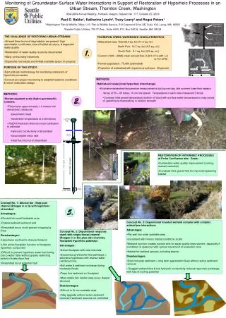
Monitoring of Groundwater-Surface Water Interactions in Support of Restoration of Hyporheic Processes in an Urban Stream, Thornton Creek, Washington GSA 2009 Annual Meeting, Portland, Oregon, Session No. 177, October 20, 2009 Paul D. Bakke1, Katherine Lynch2, Tracy Leavy1 and Roger Peters1 1Washington Fish & Wildlife Office, U.S. Fish & Wildlife Service, 510 Desmond Drive SE, Suite 102, Lacey, WA 98503 2Seattle Public Utilities, 700 5th Ave., Suite 4400, P.O. Box 34018, Seattle, WA 98124 Locking Cap Water Streambed 1.4 to 1.5 m 1. 3.8 cm diam. steel pipe 8 cm 3 mm holes 2. • THE CHALLENGE OF RESTORING URBAN STREAMS: • At least three forms of degradation are present: high stormwater runoff rates, loss of habitat structure, & degraded water quality • Restoration of water quality is poorly documented • Many confounding influences • Expensive real estate and limited available space for projects • THORNTON CREEK WATERSHED CHARACTERISTICS: • Watershed area: Total 28.4 sq. km (11.0 sq. mi.) • North Fork 16.7 sq. km (6.5 sq. mi.) • South Fork 9.1 sq. km (3.5 sq. mi.) • Current (1999 - 2008) mean annual flow: 0.261 m3/s (261 L/s or 9.2 CFS) • Human population: 75,400 (estimated) • Proportion of watershed with impervious surfaces: 49 percent • PURPOSE OF THIS STUDY: • Demonstrate methodology for monitoring restoration of hyporheic processes • Conduct pre-project monitoring to establish baseline conditions & inform restoration design • METHODS: • Habitat-unit scale (local hyporheic interchange) • Extensive streambed temperature measurements during one day, late summer base flow season • Array of 50 – 60 tubes, 10 cm into gravel. Temperature in each tube measured 3 times. • Compare intra-gravel temperature (bottom of tube) with surface water temperature to map zones of upwelling & downwelling, & relative strength • METHODS: • Stream-segment scale (hydro-geomorphic context): • Piezometer approximately 1.4 meters into streambed, measures: • piezometric head • streambed temperature at 3 elevations • VS2DHI Hydraulic-thermal model calibration to estimate • Hydraulic conductivity of streambed • Groundwater influx rate • Heat flux into/out of streambed • RESTORATION OF HYPORHEIC PROCESSES at Forks Confluence site: Goals - • Sustainable water quality improvement (cooling, nutrient reduction) • Increased intra-gravel flow for improved spawning habitat North Fork North Fork South Fork South Fork • Concept No. 1: Alluvial fan - Step-pool channel (Rosgen A or G) with hyporheic streambed • Advantages: • Fits well into small available area • Passes bedload sediment well • Streambed scour could prevent clogging by fines • Disadvantages: • Hyporheos confined to channel footprint • Little active floodplain function or floodplain hyporheic component • Difficult to prevent hyporheic water from being lost to water table without greatly restricting extent of subsurface flow • Streambed scour potential high 5. North Fork Main Stem • Concept No. 3: Depositional forested wetland complex with complex subsurface interactions • Advantages: • Fits well into small available area • Consistent with historic habitat conditions at site • Wetland function creates nutrient sink for water quality improvement, especially if inundation is seasonal, with vertical movement of anaerobic zone • Habitat for wetland species, including beaver • Disadvantages: • Does not pass sediment = long term aggradation likely without active sediment removal • Sluggish wetland flow & low hydraulic conductivity reduces hyporheic exchange, with loss of cooling potential • Concept No. 2: Depositional response reach with single-thread channel (Rosgen C or Bc) plus side channels, floodplain hyporheic pathways • Advantages: • Active floodplain with side channels • Subsurface preferential flow pathways = extensive hyporheos with diverse water residence time • Soil water & sediment recharge during moderate floods • Traps fine sediment on floodplain • More stable fish habitat (less scour, deeper alluvium) • Disadvantages: • Difficult to fit into available area • May aggrade without active sediment removal if sediment sources not controlled
3. 4. Streambed: veneer of alluvial gravel over massive clay • RESULTS: Shown for each site - • Streambed vertical thermal profile for typical late-summer period, 48 hours long • Plan view map of reach with surface-subsurface temperature difference isotherms, showing relative downwelling/upwelling • Average piezometric gradient • Groundwater influx rate & total reach-scale groundwater input to compare with surface water discharge • Crossover dates: the time when the vertical thermal gradient in the streambed changes from positive (streambed cools the surface water) to negative (streambed warms the surface water) • Estimated heat flux (cooling or warming) by streambed, with estimated cooling load in oC Streambed: veneer of alluvial gravel over massive pebbly clay Streambed: veneer of alluvial gravel over massive clay Streambed: gravel surface over sand & gravel alluvium Streambed: gravel surface over sand & gravel alluvium To 95th Street Treatment Reach Map Distribution of temperature differences at each site during one-day extensive study. Lake Washington • CONCLUSIONS: • Hydraulic conductivities at all sites, even those with alluvial subsurface, is very low • Consequently, vertical groundwater input rate is very low at all sites, even though piezometric gradient is large • Heat exchange with streambed is currently conduction dominated, so cooling load is low • Subtle hyporheic exchange is evident, but extremely slow due to impermeable sediments • Subsurface warmer than surface at two sites (KNK-T, KNK-C, in figure above), indicating substantial lack of advection flow • Lateral groundwater input evident at 2 sites (KNK-T, SFC-C, in figure above) • Crossover dates and duration vary widely by site. Inter-annual variability also can be large. Crossover period - the time during which the vertical thermal gradient in the streambed changes from positive (streambed cools the surface water) to negative (streambed warms the surface water) From Forks Confluence Reach Streambed: gravel surface over sand & gravel alluvium References: Conant, B., Jr. 2004. Delineating and quantifying groundwater discharge zones using streambed temperatures. Ground Water, 42(2):243-257. Hsieh, P. A., W. L. Wingle, and R. W. Healy, 2000. VS2DI—A Graphical Software Package for Simulating Fluid Flow and Solute or Energy Transport in Variably Saturated Porous Media. USGS Water-Resources Investigations Report 99-4130. 16 pp. Stonestrom, D.A., and Constantz, J., eds., Heat as a tool for studying the movement of ground water near streams: USGS Circular 1260. 96 pp. Streambed: gravel surface over sand & gravel alluvium To Lake Washington