Unit 2 Contour Mapping
Unit 2 Contour Mapping. What kind of maps do you know? Road map, weather map, trail map, subway map, political map, topographic map, building maps. What words are associated with maps? Latitude, Longitude, Key/Legend, Grid, Mileage scale.

Unit 2 Contour Mapping
E N D
Presentation Transcript
What kind of maps do you know? • Road map, weather map, trail map, subway map, political map, topographic map, building maps
What words are associated with maps? • Latitude, Longitude, Key/Legend, Grid, Mileage scale
What is the biggest problem in making a map of the world on a piece of paper? • Earth is round… paper is not
Who makes maps? • Cartographers
Mapping Information • North is usually at the top of the map • Location descriptions • Relative = NJ is east of PA • Absolute = grid coordinates = latitude/longitude
Equator = imaginary line that circles the Earth in between North and South poles; runs East to West • Prime Meridian = imaginary line through the old Royal Astronomical Observatory in Greenwich, England; runs North to South
Latitude = distance in degrees North or South of the Equator; also known as parallels • Longitude = distance in degrees East or West of the Prime Meridian; also known as meridians
Time Zones are determined by the meridians or longitude lines on a map • Every 15° from the prime meridian in Greenwich, England… 24 time zones • If you travel West of England, you subtract an hour… traveling East, you add an hour
Map Projections • Map projection is made when points and lines on a globe’s surface are transferred onto paper • Different projections create different distortions depending on purpose
Mercator Projection • Straight longitude and latitude lines that intersect at right angles. • Scale is true at the equator or at two standard latitude lines of equal distances from the equator. • Areas near poles are distorted.
Robinson Projection • Latitude lines are parallel, but longitude lines curve into poles. • Some distortion of area, shape • Used to show visually appealing pictures of the whole world
Conic Projection • Lines of latitude and longitude intersect at right angles • Meridians are straight and parallels are arcs • Accurate for small areas… road maps, weather maps
Mileage Scale • Map scale is the relationship between the distances on the map and actual distances on Earth’s surface. • Bar scale - • Verbal scale – one inch = 100 miles • Ratio scale – 1:100
"On this map there's a bar scale! All you have to do is take a piece of paper, mark off miles from the bar scale onto the edge of the paper, and then hold the edge of the paper so that it lies along Bo Ring Way
One inch = four miles. First, place a ruler marked in inches on the map and measure how many inches separate the two towns on the map! The two towns are about 2.5 inches apart! • 2.5 inches times 4 miles per inch = 10 miles apart on the ground!"
"That's more difficult because the road is curved! You need some way to estimate distance along the curves of Dingle Way from Louberg to Luluville. you can use a piece of string! Take the string and lay it out along the route. Then, straighten the string out and hold it against the bar scale or a ruler!
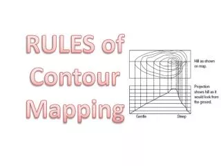
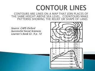
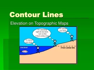
Topographic maps • “Topo” means shape • Topographic maps show the shape and height of the land on a flat piece of paper • Elevation is the distance of a location above or below sea level
Contour lines connect points on the map that have the same elevation • Index contours are contour lines with elevation numbers
Contour Mapping Rules 1. Hills and depressions are represented by circles. Hachure Lines are used to show depressions. Hill Depression
Contour Mapping Rules 2. Contour lines never cross.
Contour Mapping Rules 3. When contour lines meet a river or a stream they form a “V” the points upstream.
Mapping Quiz Topics • Equator and Prime Meridian • Latitude vs Longitude • Three map projections • What is a topographic map? • Topographic Terms • Topographic Rules (3) • Map symbols
The Average Slope • Slope = the amount of deviation from the horizontal • Ex: hillside skiing Bunny hill Intermediate Professional
In math class, you learn slope as: Slope = rise run Slope = y2 – y1 x2 – x1
Slope = y2 – y1 x2 – x1 = 3 – 0 6 – 0 = 0.5
Websites • http://nationalatlas.gov/articles/mapping/a_latlong.html • http://plasma.nationalgeographic.com/mapmachine/ • http://www.nationalgeographic.com/xpeditions/lessons/01/g68/mapmaking.html • http://members.shaw.ca/hollylloyd/theme/mappingskills.htm • http://interactive2.usgs.gov/learningweb/teachers/exploremaps.htm • http://www.colorado.edu/geography/gcraft/notes/mapproj/mapproj_f.html
Topographic websites • http://www.compassdude.com/topographic-maps.shtml • http://members.aol.com/bowermanb/maps.html#topo • http://www.topozone.com/states/NewJersey.asp