Enhancing Water and Marine Reporting: Insights from the EEA Seminar
240 likes | 361 Views
The EEA seminar held on June 1, 2023, focused on improving water and marine reporting processes. Key topics included the assessment of implementation, evaluation of good status indicators, and compliance monitoring in relation to the Water Framework Directive (WFD). Discussions revealed common challenges such as data coherence and quality, the role of WISE technology, and the importance of integrating monitoring programs. A collaborative approach between Member States and agencies like Copernicus and EMODnet is crucial for effective data sharing and to drive policy effectiveness in managing aquatic ecosystems.

Enhancing Water and Marine Reporting: Insights from the EEA Seminar
E N D
Presentation Transcript
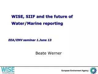
WISE, SIIF and the future of Water/Marine reporting EEA/ENV seminar 1.June 13 Beate Werner
Information for better implementation in the policy cycle EEA ENV • Implementation assessment- goodstatus • Loads • Concentrations • Pressures • Impacts • Measures • Messages on theproblem • SOE information- longtermtrends • soil, forestlanduse, • Research info • Public • Outside EU 28 • Compliance- Exemption • Transposition • deadlines, • Infringementprocdures DPSIR Policycycle Information neededtointerpret on wider ecosystembasis ‘Policy performance’ - Compliance indicators ‘Policy effectiveness’- compliance indicators Initial assessmentandreviewofassessment
WISE Freshwater / Marine • Commonalities: • (lack) of coherence and completeness of reported data is common • Prevailing quality issues • Georeference data ‘around’ coastline • Common pressure data land based source, nutrients, chemicals • Same cornerstones regarding IT systems in EEA (one solution for reporting mechanisms, visualisation, data viewer and retrieval
Marine information • Map and explain progress towards good environmental status across Europe • Starts with initial assessment reporting in 2012 • With focus on status, pressures, and human activities • Will become elaborated through • Data related to initial assessments • Monitoring programmes and data from them • Criteria and indicators for good environmental status • Programmes of measures • 2018 reporting • Most of this does not exist (yet) but information sharing can be based on WISE technology
Role of Copernicus and Emodnet • MS decide what MSFD data sets are; • MS can decide to ask Emodnet to ‘share’ their MSFD data – but others will have to be able to re-find them; • MS can decide to ask Emodnet to process their data according to specification; • MS can request specific information products related to the physical marine environment from Copernicus; • Emodnet and Copernicus would have to adapt relevant products to MSFD spatial units; • If MS do not activate these initiatives they are not able to operate in MSFD.
Support cross cutting themes Combine Land Cover 2006 with Natura 2000 Save & Share Add Layer DG Environment (ENVI)Nature - Unit B.3 Natura 2000 - Protected sites in Europe Add Layer European Environment Agency (EEA)Natural Systems and Vulnerability – Unit NSV.5 Corine Landcover - 2006
A ”quick-and-dirty” mashup for BWD and UWWTD from WISE Map Service with ArcGIS online
Re-using data from several data flows – 1 as starting point for more detailed statistical assessments on the interrelation of the thematic themes represented by the results. • Chlorophyll-a concentrations in 2012 provided at Eionet water stations – coastal and transitional waters (Source: WaterBase; WISE) • Bathing water quality (BWD: 2012) • Coastal waters (WFD)
WISE data maintanance - need for - INSPIRE-compliant spatial datasets and - tabular datasets fit for integrated asessments Tabular datasets Monitoring data, status info – water quality (ID, parameter values) Monitoring data, status info – water quantity (ID, parameter values) Reported data, - emissions, treatment type, compliance,.. (ID, parameter values) WFD River Basin Districts (ID, shapefiles, attributes) Monitoring stations - quality (ID, ID-WB, coordinates, attributes) Monitoring stations - quantiity (ID, ID-WB, coordinates, attributes) Facilities (industries, treatment plants,..) (ID, ID-WB, coordinates, attributes) WFD ground water bodies (WB) (ID, shapefiles, attributes) WFD surface water bodies (WB) Rivers, lakes, transitional, coastal (ID, shapefiles, attributes) Udate frequency WISE Main Rivers, Main Lakes (ID, shapefiles, attributes) Reference GIS datasets NUTS1, NUTS2, NUTS3,.. (ID, shapefiles, attributes) Country boarders (shapefiles) Coastline(s) (shapefiles) Spatial datasets
How does it work? Users Geoportals Home web sites INSPIRE metadata INSPIRE discovery service to search for data and services Using metadata catalogue to search for data and services Published on INSPIRE view service Use other spatial data services Download data to your computer View data INSPIRE download service Use (invoke) spatial data services INSPIRE invoke spatial data services Provided by INSPIRE Annex I, II, III data specifications Data / service providers Make spatial data INSPIRE conformant INSPIRE transformation service
Reporting dataflow – now: reporting without INSPIRE? INSPIRE Reportnet Spatial data sets conform\ant with INSPIRE INSPIRE View, download, other spatial data services Discovery service on metadata (B) Providing download and other services and direct access to data Provide access to spatial data sets and services Metadata for spatial data set and services Duplicated data and double workflows ! (A) Uploading spatial data sets and tabular data Country A Sub-set of data for reporting Data
Reporting dataflow – scenario 1: including INSPIRE into reporting data flow Sharing registers, registry services INSPIRE Reportnet Link to spatial data (URL, URI) Discovery service on metadata Spatial data sets conformant with INSPIRE Ensure object referencing (geospatial object-identifier management) Upload thematic data with reference to spatial objects Metadata for spatial data set and services Provide access to spatial data sets and services INSPIRE View, download, other spatial data services Download spatial data sets for reporting purposes, using (INSPIRE download service) Country A Data
Reporting dataflow – scenario 2: INSPIRE and direct access to data (but how would be dealt with the requirement to have an official Confirmation on the data being reported and version history) Sharing registers, registry services INSPIRE Reportnet Link to spatial data (URL, URI) Discovery service on metadata Spatial data sets conformant with INSPIRE Download spatial data sets for reporting purposes, using INSPIRE download service Metadata for spatial data set and services Harvest, download Provide access to spatial data sets and services Ensure object referencing (identifier management) INSPIRE View, download, other spatial data services Services, interfaces Country A Sub-set of data for reporting Data
Data flows and web services in WISE European Monitoring campaigns Other data sources Monitoring data in MS datasets • Reporting by countries • SoE • EU Directives • waterstatistics GIS datasets • Professionals • Near real-time data • GMES • Utilities • industries • Public participation • Cityzen science Modelling - now casting - Forecasting - Scenarios - Data gap filling QA/QC WISE Common Data Structure Reference GIS datasets Static maps and graphs Interactive maps Map layers & platforms Model systems European thematic datasets Pre-defined query functions CSI xx WaterBase Indicators Modelling services DataViewer MapViewer Map services Web services
Perspectiveof Input/output versus geospatial/tabular (attribute) data PRODUCTS INPUT OUTPUT Arc GIS Online GEOSPATIAL Mapviewerandservices Visuali-sationDown-loads Common datastructure Central orDecentral SIIF - PILOTE Quality assurance; MS dialogue TABULAR(attribute) Data viewer
Questions to discuss –on the reporting mechanism/procedures • Issues of comparability, scale and reporting frequency • Are things really getting easier for MS?, how do we ensure data comparability in a decentralised system? • There is still an issue with reporting frequency, as deadlines for assessments need to be kept to avoid late updates and redoing of the assessments. • internal procedures EEA/ENV contractors ETC • Communication of SIIF development – event in autumn? • How do we want to develop the WISE IP (amendment or annex?) – next steps in WISE SG?
Questions for discussion on IT architecture consequences • What kind of changes do we need for DD and reportnet to make it fit for WFD information (complexity) • Do we have a coding issue in the interrelation between spatial and tabular (attribute) data and how to solve it? • How to go on with textual information – e.g. the wiki type of solution. Does this fit into reportnet? • What need to be done to make real use of the facilities/possibilities of INSPIRE – realising Darja’s scenarios
WISE – SIIF EU and MS level • Whatreflects MS SIIFs on EU level? • Formal definition? • RoleofmetadataandInspirecompliance in MS/EU SIIF structure • Are therespectiveinformationportals/hubsidenticallywith geo-portals, orwhatwouldbetherelationbetween SIIF hubsand geo-portals
Lessons learned – • Reporting: • WFD could not use full ReportNet features development needed to better facilitate QA/QC and automatisation, DD development • Reporting of Geo-data; stability • Data consistency, needs better searchability one consistent data structure across tabular and spatial data • Dissemination: • Streamlining of Viewers; • Website and entry pages too many quick and dirty solutions
How does it look like now? And how we would like to move • Data and Reporting: • ReportNet as reporting tool: • having the same structure (DD) and QA/QC procedures will help in processing information and data • in next years specific tools for GIS data to be used (ArcGIS online, SDI links). Ensure INSPIRE compliance • Use data at MS source (“decentralised system”), see Floods and UWWTD • Data maintenance: one consistent structure across spatial and tabular data • Enabling better unstructured information (verbally described) • Dissemination of European data as: • Interactive viewers towards one viewer system enabling integrated analysis • Website(s) update/change the website to host more unstructured information including wiki