Download
1 / 15
150 likes | 214 Views
This educational project involves students using maps and geospatial data to select sites for renewable energy projects. They explore various renewable energy sources and analyze existing facilities. The activity covers solar, biomass, hydroelectric, tidal, wind, wave, geothermal, and ocean/lake source energy. Suitable for college and high school Earth science and physics courses. Utilize Google Earth for mapping exercises and understanding energy-related Earth processes.

E N D
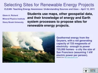
Selecting Sites for Renewable Energy Projects CLEAN: Teaching Energy Awareness: Understanding Sources and Uses – April 12, 2011 Students use maps, other geospatial data, and their knowledge of energy and Earth system processes to propose sites for renewable energy projects. Glenn A. Richard Mineral Physics Institute Stony Brook University Geothermal energy from the Geysers, with a net generating capacity of 725 megawatts of electricity - enough to power 725,000 homes - a city the size of San Francisco (assuming 1 kW electric power per person).Statistics from http://www.geysers.com/ Photo fromhttp://pubs.usgs.gov/gip/dynamic/geothermal.html
Students will … Learn how renewable energy relates to Earth system processes Use Google Earth to explore a variety of renewable energy sources Study examples of existing renewable energy facilities Create map overlays on Google Earth Use maps and other data to identify locations where these energy sources could be used Use Google Earth to propose, mark, and document specific sites for renewable energy projects Consider possible environmental effects of the development of renewable energy resources Evaluate a set of maps that use a variety of means of displaying information about bioenergy in the United States Goals Rance TidalPower Station,France Ep = ½ A ρ g h2 (Potential energy: Proportional to the square of the tidal range)
This activity is suitable for: Introductory undergraduate geoscience and environmental studies courses for majors in these areas as well as non-majors Upper level undergraduate courses that focus on energy or environmental issues Advanced high school Earth science or physics courses It could be offered in a computer laboratory during instructional time (preferred) or as homework. Context for Use
Solar Energy Biomass Energy Hydroelectricity Tidal Power Wind Energy Wave Energy Geothermal Energy Ocean or Lake Source Cooling Osmotic Energy Student groups choose and placemark locations, on Google Earth, for each of the following sources of renewable energy: http://en.wikipedia.org/wiki/Photovoltaics Photovoltaic system 'tree' in Styria, Austria
For this activity: Raster maps downloaded from the Energy Information Administration, and made into overlays. Maps in equirectangular projection (plate carré) overlay best. Polluted site data available from the EPA in kmz format. Data Formats that Can Be Used in Google Earth Google Earth Pro can also map ArcGIS shapefile data, and save it in kmz format. See EIA: Renewable Potential Maps http://www.eia.doe.gov/emeu/reps/rpmap/rp_contents.html
What if the overlay does not align well? If a map does not overlay perfectly, it can be adjusted to match particular the region of interest or it can be cut up. This map from the California Wind Resource Maps site is shown optimized for the Bay Area. The green handles can be used to move, stretch, or rotate the map. A slider, not shown here, can be used to adjust the transparency. See California Wind Resource Maps: http://www.energy.ca.gov/maps/wind.html
Statkraft Osmotic Power Prototype Islay LIMPET Wave Power Plant Sound of Islay Tidal Power Honolulu Seawater Air Conditioning Case Studies Provide Ideas and Depth The following examples have been posted on the Google Earth Community Forums: See examples by following this link to Selecting Sites for Renewable Energy Projects: http://serc.carleton.edu/NAGTWorkshops/teaching_methods/google_earth/examples/renewable_energy.html or see the next four slides.
Example for study posted on the Google Earth Community Forums:Statkraft Osmotic Power Prototype Osmotic Power Prototype 4 kW; Target for 2015: 25 MW Via osmosis, water flows through the semipermeable membrane from the freshwater chamber (green) to the saltwater chamber (blue). This increases the pressure in the saltwater chamber. The pressurized water drives a turbine as it is released, and this runs a generator to produce electricity. Posted at http://bbs.keyhole.com/ubb/ubbthreads.php?ubb=showthreaded&Number=1404273
Example for study posted on the Google Earth Community Forums:Islay LIMPET Wave Power Plant Wave Energy Waves arriving at the shoreline causes a set of water columns to rise and fall. The water columns alternately compress and decompress air confined in chambers, and these drive a turbine connected to a generator. The turbine operates as the air moves in either direction. Installed capacity: 500 kW Posted at http://bbs.keyhole.com/ubb/ubbthreads.php?ubb=showthreaded&Number=1409434
Example for study posted on the Google Earth Community Forums:Sound of Islay Tidal Power Array Tidal Power Image from FAQ at:http://islayenergytrust.files.wordpress.com/2010/12/sound-of-islay-faq-november-2010.pdf Proposed 10-megawatt tidal power array in The Sound of Islay between the Isles of Islay and Jura designed to generate sufficient electricity to supply the equivalent of the entire Isle of Islay.(population ~3500 + agriculture and distilleries) Posted at http://bbs.keyhole.com/ubb/ubbthreads.php?ubb=showthreaded&Number=1409728
Example for study posted on the Google Earth Community Forums:Honolulu Seawater Air Conditioning Ocean Source Cooling Service area shown in Google Earth. 45°F seawater from offshore cools buildings, then is released into shallow water. But deep water a short distance offshore is needed, and Long Island is adjacent to a broad continetal shelf. We can study this one and leave it for the West Coast and deep lakes. Corenell Universit, not too far away, uses Cayuga Lake for cooling water. Ocean temperature Profile 8°15' N, 47°36' W, May 17, 1957 Posted at http://bbs.keyhole.com/ubb/ubbthreads.php?ubb=showthreaded&Number=1405003
Collecting Maps from Diverse Sources New York Times Long Island Sound Tidal Power Proposal, 1913 Map for the overlay was cropped from a pdf file of the article. Selected features from the map were traced onto Google Earth as paths. With a bit of creative fudging, nearly all maps can be used as overlays. Posted at http://bbs.keyhole.com/ubb/ubbthreads.php?ubb=showthreaded&Number=1375833
Students Investigate the Environmental Consequences of Using Renewable Energy Usine marémotrice de la Rance, France Rance Tidal Power Station Flax Pond Tidal Marsh, Long Island Sound Existence of salt marshes on Long Island Sound depends upon tides. These marshes can be seen on Google Earth. Tidal barrages alter the tidal cycle.
Continuing the Activity in Greater Depth Students can seek out case studies, then study a local area, such as their own city or region. Look for news articles and other sources relating to your local area. Propose some projects and map them using Google Earth or ArcGIS. • Consider possible renewable energy projects for one’s own area. First investigate what forms of renewable energy might be appropriate. Example: Long Island is on the coastline, adjacent to estuaries and the Atlantic Ocean: • Wind • Tidal • Wave • Small Hydropower • Osmotic
Develop a collection of educational materials for teaching about related Earth system concepts (e.g. insolation, wind, waves, tides) Build a set of case studies of actual projects for each type of energy source (e.g. solar, wind, biomass, tidal) Build a collection of maps of resources (e.g. wind, insolation, tidal range, wave heights, lake and ocean temperature profiles) Provide an annotated (how to) example collection of energy and infrastructure portfolios for a city or region for others to emulate for their own region. To advance this strategy …