Mapping our World
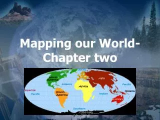
Mapping our World. Chap. 2. Latitude and Longitude 2.1 Types of Maps 2.2 Remote Sensing 2.3. Latitude and Longitude – 2.1. Objectives. Compare & contrast latitude & longitude Describe how time zones vary. Cartography. Science of mapmaking. Locating objects on a sphere.


Mapping our World
E N D
Presentation Transcript
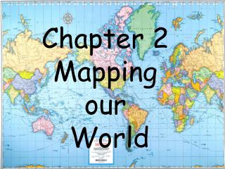
Mapping our World Chap. 2 Latitude and Longitude 2.1 Types of Maps 2.2 Remote Sensing 2.3
Latitude and Longitude – 2.1 Objectives • Compare & contrast latitude & longitude • Describe how time zones vary
Cartography Science of mapmaking
Locating objects on a sphere • Latitude (Lat = fLat) These lines are horizontal and tell how far North or South an object is
Locating objects on a sphere • Latitude • Equator drawn at center
Locating objects on a sphere • Latitude • Equator drawn at center • Lines are parallel
Locating objects on a sphere • Latitude • Equator drawn at center • Lines are parallel • 90º N is at the north pole
Locating objects on a sphere • Latitude • Equator drawn at center • Lines are parallel • 90º N is at the north pole
Practice Problem 1 The Earth’s circumference is about 40 000 km. There are 360º in a circle. What is the distance between degrees? 40 000 km
Locating objects on a sphere • Latitude • Equator drawn at center • Lines are parallel • 90º N is at the north pole • Each latitude line is 111km
Locating objects on a sphere • Latitude • Equator drawn at center • Lines are parallel • 90º N is at the north pole • Each latitude line is 111km • Degrees are divided into minutes and seconds. 1 º = 60’ 1’ = 60”
Locating objects on a sphere • Longitude These are ‘long’. They go up and down and tell how far East or West an object is
Locating objects on a sphere • Longitude • Travel through the poles
Locating objects on a sphere • Longitude • Travel through the poles • They are NOT parallel
Locating objects on a sphere • Longitude • Travel through the poles • They are NOT parallel • The prime meridian is 0º longitude and goes through Greenwich, England
Locating objects on a sphere • Longitude • Travel through the poles • They are NOT parallel • The prime meridian is 0º longitude and goes through Greenwich, England • On the opposite side of the globe the prime meridian is the International date line.
Practice Problem 2 What is the distance between longitude degrees?
Time Zones • The Earth is divided into 24 zones
Practice Problem 3 How many degrees for each time zone? (Remember there is a total of 360º)
Time Zones • The Earth is divided into 24 zones • The dividing lines may be slightly adjusted
Time Zones • The Earth is divided into 24 zones • The dividing lines may be slightly adjusted • The International Date line marks a division between
Time Zones • The Earth is divided into 24 zones • The dividing lines may be slightly adjusted • The International Date line marks a division between • When you cross this traveling West you add a calendar day
Time Zones • The Earth is divided into 24 zones • The dividing lines may be slightly adjusted • The International Date line marks a division between • When you cross this traveling West you add a calendar day • When you cross this East you move the calendar back a day
Types of Maps – 2.2 Objectives • Compare and contrast different map projections • Analyze topographic maps • Describe map characteristics, such as map scales and legends
Types of Maps • Mercator Projections
Types of Maps • Mercator Projections • Map with parallel lines of latitude and longitude • It distorts shapes
Types of Maps • Mercator Projections • Conic Projections
Types of Maps • Mercator Projections • Conic Projections • Made by projecting points and lines onto a cone • Some object not distorted
Types of Maps • Mercator Projections • Conic Projections • Gnomonic Projections • Made by projecting points and lines to paper that touches globe at single point
Types of Maps • Mercator Projections • Conic Projections • Gnomonic Projections • Made by projecting points and lines to paper that touches globe at single point • Useful for navigation
Types of Maps • Topographic Maps
Types of Maps • Topographic Maps • Contour lines 900 Drawn through places at the same elevation
Types of Maps • Topographic Maps • Contour lines • Index contours 900 Labeled contour lines.
Types of Maps • Topographic Maps • Contour lines • Index contours • Depression contour lines have hachures
Other features • Map Legends Gives names of map features
Other features • Map Legends • Map Scales Tells ratio of map distances to real distances
Practice Problem 4 What is the distance from Buffalo to Albany?
Remote Sensing – 2.3 Objectives • Compare & contrast the different forms of radiation in the EM spectrum • Describe how satellites and sonar are used to map Earth’s surface • Describe the Global Positioning System
On-site observations You go to the location you want to map
On-site observations • Remote sensing
On-site observations • Remote sensing • Satellites are often used