Download
1 / 1
10 likes | 203 Views
GP13A-0766. New software for the World Magnetic Model (WMM) Adam Woods (1, 2) , Manoj Nair (1,2) , Stefan Maus (1,2) , Susan McLean (1) 1. NOAA’s National Geophysical Data Center, Boulder, CO 2.CIRES, University of Colorado, Boulder, CO.

E N D
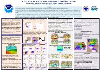
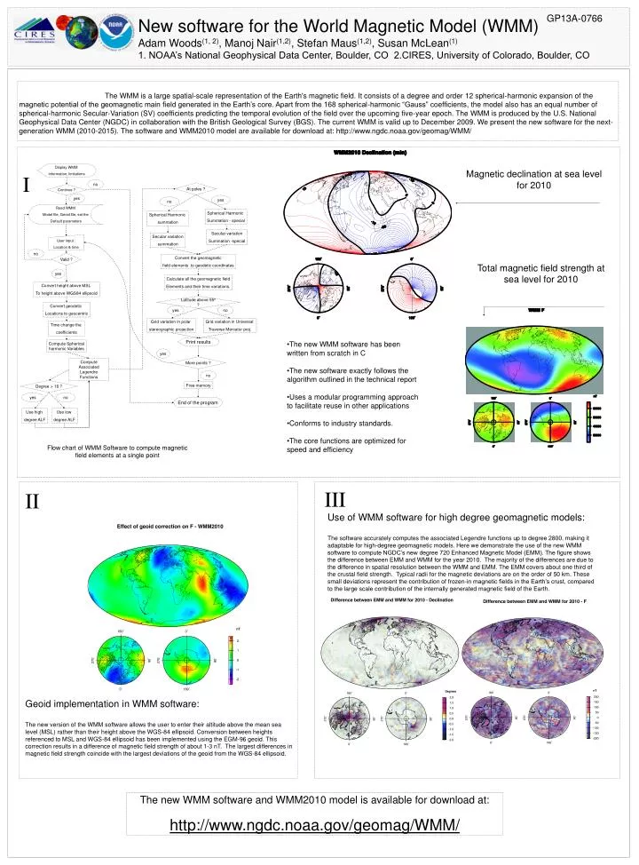
GP13A-0766 New software for the World Magnetic Model (WMM) Adam Woods(1, 2), Manoj Nair(1,2), Stefan Maus(1,2), Susan McLean(1) 1. NOAA’s National Geophysical Data Center, Boulder, CO 2.CIRES, University of Colorado, Boulder, CO The WMM is a large spatial-scale representation of the Earth's magnetic field. It consists of a degree and order 12 spherical-harmonic expansion of the magnetic potential of the geomagnetic main field generated in the Earth’s core. Apart from the 168 spherical-harmonic “Gauss” coefficients, the model also has an equal number of spherical-harmonic Secular-Variation (SV) coefficients predicting the temporal evolution of the field over the upcoming five-year epoch. The WMM is produced by the U.S. National Geophysical Data Center (NGDC) in collaboration with the British Geological Survey (BGS). The current WMM is valid up to December 2009. We present the new software for the next-generation WMM (2010-2015). The software and WMM2010 model are available for download at: http://www.ngdc.noaa.gov/geomag/WMM/ Display WMM information, limitations Magnetic declination at sea level for 2010 I no At poles ? Continue ? yes yes no Read WMM Model file, Geoid file, set the Default parameters Spherical Harmonic Summation - special Spherical Harmonic summation Secular variation Summation -special Secular variation summation User input : Location & time no Valid ? Convert the geomagnetic field elements to geodetic coordinates Total magnetic field strength at sea level for 2010 yes Calculate all the geomagnetic field Elements and their time variations. Convert height above MSL To height above WGS84 ellipsoid Latitude above 55º ? Convert geodetic Locations to geocentric yes no Grid variation in polar stereographic projection Grid variation in Universal Traverse Mercator proj. Time change the coefficients • The new WMM software has been written from scratch in C • The new software exactly follows the algorithm outlined in the technical report • Uses a modular programming approach to facilitate reuse in other applications • Conforms to industry standards. • The core functions are optimized for speed and efficiency Print results Compute Spherical harmonic Variables yes More points ? Compute Associated Legendre Functions no Degree > 16 ? Free memory yes no End of the program Use high degree ALF Use low degree ALF Flow chart of WMM Software to compute magnetic field elements at a single point III II Use of WMM software for high degree geomagnetic models: The software accurately computes the associated Legendre functions up to degree 2800, making it adaptable for high-degree geomagnetic models. Here we demonstrate the use of the new WMM software to compute NGDC’s new degree 720 Enhanced Magnetic Model (EMM). The figure shows the difference between EMM and WMM for the year 2010. The majority of the differences are due to the difference in spatial resolution between the WMM and EMM. The EMM covers about one third of the crustal field strength. Typical radii for the magnetic deviations are on the order of 50 km. These small deviations represent the contribution of frozen-in magnetic fields in the Earth’s crust, compared to the large scale contribution of the internally generated magnetic field of the Earth. Geoid implementation in WMM software: The new version of the WMM software allows the user to enter their altitude above the mean sea level (MSL) rather than their height above the WGS-84 ellipsoid. Conversion between heights referenced to MSL and WGS-84 ellipsoid has been implemented using the EGM-96 geoid. This correction results in a difference of magnetic field strength of about 1-3 nT. The largest differences in magnetic field strength coincide with the largest deviations of the geoid from the WGS-84 ellipsoid. The new WMM software and WMM2010 model is available for download at: http://www.ngdc.noaa.gov/geomag/WMM/

![MBN Explorer [ 1,2] is a multi-purpose software package designed to study molecular systems of](https://cdn1.slideserve.com/2099881/slide1-dt.jpg)