Download
1 / 30
300 likes | 436 Views
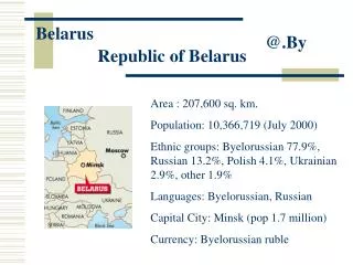
MRV approaches in the BMU Belarus peatland project. Hans Joosten Greifswald University, Germany. Eastern Europe: famous for its vast and largely undisturbed peatlands. Rospuda Valley, Poland. Belarus has high proportion of peatlands...

E N D
MRV approaches in the BMU Belarus peatland project Hans Joosten Greifswald University, Germany
Eastern Europe: famous for its vast and largely undisturbed peatlands... Rospuda Valley, Poland
Belarus has high proportion of peatlands... fens (green), bogs (red), transitional peatlands (purple): former extent ~15% of the area
Present area of drained peatlands: 1.5 mio ha (agriculture 72%, forestry 25%, peat extraction 3%)
CO2 emission Central Europe is peatland emission hot spot
BMU funded rewetting project (2008-2011) • builds on GEF funded rewetting project (42,000 ha) • strong support of Belarusian government: • carbon credits • reduction of fires (radioactivity!)…
BMU funded rewetting project (2008-2011) Deliverables: • methodology for GHG assessment • standard for voluntary trade • 15,000 ha rewetted and sustainably managed • local capacity
Measuring directly is complicated, time consuming, expensive ( € 10,000 /ha/yr) proxy indicators
Mean water level is best predictor of emissions (meta-analysis of 25 site parameters in W-Europe)
CO2 emissions clearly correlate with water levels: they become less with higher water levels
CH4 emissions clearly correlate with water levels: they increase when higher than 20 cm - surface
N2O emissions clearly correlate with water levels: they do not occur when higher than 15 cm - surface
N2O erratic, but lower with higher water levels Leave N2O emissions out conservative estimate
By rewetting, greenhouse gas emissions decrease, but less between – 20 cm and 0 cm
Emissions strongly related to water level Vegetation strongly related to water level Use vegetation as indicator for emissions!
site factor gradient species groups site factor classes 1 2 3 4 5 subunits 1 2 1 2 In an environmental gradient some plant species occur together; others exclude each other. Species groups (and their absence!) indicate site conditions much sharper than individual plant species: “vegetation forms”.
Vegetation types calibrated for GHG emissions: GESTs: Greenhouse gas Emission Site Types Some examples: Water level Vegetation CH4 CO2 GWP
GESTs with indicator species groups Each GEST with typical species Each GEST with typical GHG emissions
Benefits of vegetation as a GHG proxy: • reflects long-term water levels provides indication on GHG fluxes per yr • is controlled by factors that control GHG emissions (water, nutrients, acidity, land use…) • is responsible for GHG emissions via its own organic matter (root exudates!) • may provide bypasses for increased CH4 via aerenchyma (“shunt species”) • allows rapid and fine-scaled mapping • Vegetation is a more comprehensive proxy than water level!
Disadvantages of vegetation as a proxy: • slow reaction on environmental changes: ~3 years before change in water level is reflected in vegetation (negative effect faster) • needs to be calibrated for different climatic and phytogeographical conditions
Vegetation forms: developed for NE Germany test of correlations in Belarusian peatlands
BMU Belarus project: • Calibration of NE German model for Belarus: • relation vegetation ↔ water level (CIM position) • relation water level ↔ GHG emissions (CIM position) • Completion of model (“gap filling”) • Consistency test with international literature • Development of conservative approaches • Selection of rewetting sites • Mapping of vegetation before rewetting (assessment of emission baseline ) • Monitor water level and vegetation development (ex-post emission monitoring)
Perspectives of GEST-approach: • Ex-ante baseline assessment with ex-post evaluation • Fine-scaled mapping • Remote sensing monitoring • Continuous refinement with progressing GHG research • Addition of new modules (forest, transient dynamics) • Simple, cheap, reliable…
Developed with • Jürgen Augustin (ZALF) • John Couwenberg (DUENE) • Dierk Michaelis (Uni Greifswald) • Merten Minke (APB / CIM) • Annett Thiele (APB/ CIM) • And many more…
GESTs! info: joosten@uni-greifswald.de