Comparative Analysis of Fire Detection Products in the La Plata Basin (1995-2009)
Explore the spatial and temporal variability of fire occurrences in the La Plata Basin using remote sensing data from 1995 to 2009. Compare five global databases, evaluate their effectiveness in describing fire dynamics, and assess potential impacts. Discover the climate and human activity influences on fire occurrence.

Comparative Analysis of Fire Detection Products in the La Plata Basin (1995-2009)
E N D
Presentation Transcript
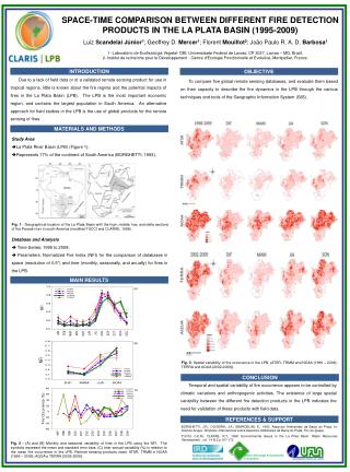
SPACE-TIME COMPARISON BETWEEN DIFFERENT FIRE DETECTION PRODUCTS IN THE LA PLATA BASIN (1995-2009) Luiz Scandelai Júnior1; Geoffrey D. Mercer1; Florent Mouillot2; João Paulo R. A. D. Barbosa1 1- Laboratório de Ecofisiologia Vegetal- DBI, Universidade Federal de Lavras: CP 3037, Lavras – MG, Brazil. 2- Institut de recherche pour le Développement - Centre d'Ecologie Fonctionnelle et Evolutive, Montpellier, France. . INTRODUCTION OBJECTIVE Due to a lack of field data or of a validated remote sensing product for use in tropical regions, little is known about the fire regime and the potential impacts of fires in the La Plata Basin (LPB). The LPB is the most important economic region, and contains the largest population in South America. An alternative approach for field studies in the LPB is the use of global products for the remote sensing of fires. To compare five global remote sensing databases, and evaluate them based on their capacity to describe the fire dynamics in the LPB through the various techniques and tools of the Geographic Information System (GIS). MATERIALS AND METHODS • Study Area • La Plata River Basin (LPB) (Figure 1); • Represents 17% of the continent of South America (BORGHETTI, 1993). Fig. 1 - Geographical location of the La Plata Basin with the high, middle, low, and delta sections of the Paraná river in south America (modified TUCCI and CLARKE, 1998). • Database and Analysis • Time Series: 1995 to 2009; • Parameters: Normalized Fire Index (NFI) for the comparison of databases in space (resolution of 0.5°) and time (monthly, seasonally, and anually) for fires in the LPB. MAIN RESULTS (A) (B) Fig. 3- Spatial variability of fire occurrence in the LPB. (ATSR, TRMM and NOAA (1998 – 2009); TERRA and AQUA (2002-2009)). CONCLUSION Temporal and spatial variability of fire occurrence appears to be controlled by climatic variations and anthropogenic activities. The existence of large spatial variability between the different fire detection products in the LPB indicates the need for validation of these products with field data. (C) Fire Occurrence (%) REFERENCES & SUPPORT BORGHETTI, J.R.; OLIVEIRA, J.A.; SBARDELINI, E., 1993. Aspectos Ambientais da Bacia do Prata. In: Instituto Acqua, Simpósio Internacional sobre Aspectos Ambientais da Bacia do Prata, Foz do Iguaçu. TUCCI, C.E.M.; CLARKE, R.T., 1998. Environmental Issues in the La Plata Basin. Water Resources Development , vol. 14 N.2 p 157-173. Fig. 2 - (A) and (B) Monthly and seasonal variability of fires in the LPB using the NFI. The symbols represent the mean and standard error bars. (C) Inter-annual variability (%) in relation to the mean fire occurrence in the LPB. Remote sensing products used: ATSR, TRMM e NOAA (1998 – 2009); AQUA e TERRA (2002-2009). Centre d'Ecologie Fonctionnelle et Evolutive