Download
1 / 33
330 likes | 419 Views
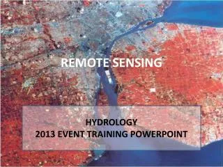
Learn about the USGS National Hydrography Dataset (NHD) project in Indiana from 2011 to 2013, focusing on data conversion, conflation, and improving the accuracy of water features using local-resolution mapping.

E N D
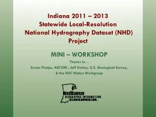
MINI – WORKSHOP Thanks to… Susan Phelps, AECOM ; Jeff Simley, U.S. Geological Survey, & the IGIC Waters Workgroup Indiana 2011 – 2013Statewide Local-Resolution National Hydrography Dataset (NHD) Project
Topics • ProjectBackground • Approach • Project Tasks • Conversion • Conflation • Status / Next Steps
What is the USGS National Hydrography Dataset (NHD)? • Feature-based database of nation’s surface water drainage system maintained by the USGS • Network of streams, rivers, and other flowlines; lakes, ponds, and other waterbodies • Suitable for modeling water flow & geocoding local features and events
What is the USGS NHD? • Flowline (Stream/River, Canal/Ditch, Artificial Path) • Waterbody (Lake/Pond, Swamp/Marsh, Reservior) • Areas (Large Stream/River, Large Canal/Ditch) • Points (Gaging Station, Well) • Lines (Dams)
Data Organized into Hydrologic Units • Hydrologic Units Codes (HUC) assigned to each
Data Organized into Hydrologic Units • HUC & WBD Maintained by USGS with the help of StatedataStewards
Background Streams – the fundamental core of the NHD
Background Flow Direction – giving intelligence to the data
Background Navigation – Creating fundamental knowledge
Background Navigation – Where does a toxic spill go?
Background Linear Referencing – Stream “Reaches”
Background Linear Referencing – Stream addresses
Improving the NHD for Indiana Current: • Features in current NHD based upon 1:24,000 USGS Topographic Quad Maps • Most users require data at better scale • Features have changed since Maps were created Update NHD using 2005 Ortho & DEM products: • Updates of physical features (existence, location) • New (Local-res) Data would be at scale of 1:2,400
Local-Resolution NHD Example High-resolution NHD 1:24,000 Scale (1”=2,000’) Local-resolution NHD 1:2,400 Scale (1”=200’)
Local-Resolution NHD Example Production done by HUC 8 (Subbasins) Existing 1:24,000 High-Resolution NHD
Local-Resolution NHD Example New 1:1,200 or 1:2,400 Local-Resolution NHD Developed for 6AC Sub-catchment derived from 2005 DEM
Local-Resolution NHD Example New 1:1,200 or 1:2,400 Local-Resolution NHD Developed for 6AC Sub-catchment derived from 2005 DEM and matched to 2005 orthophotography
Local-Resolution NHD Example End Result = New 1:1,200 or 1:2,400 scale Local-Resolution NHD
Approach Pilot study conducted in Summer 2009 • Small watershed in Hamilton County(Morse Reservoir and agricultural land) • Broad representation of the waterfeatures to be included in the statewideproject • Designed to provide a basis for streamlocation accuracy and upstreamdrainage area limit assessments • Results = Impressive Results andBaseline budget established (15% more local-resolution hydro captured than what County GIS maintained)
Approach Statewide project completed by HUC-8 watershed sub-basin in phases: • AECOM Selected for Contractwith the State in 2010 • Local subcontractors will assistwith hydrography development(Cripe & Pinnacle) • Upper Eel will be first sub-basin completed • Linework will undergo QC and approval by IGIC Waters workgroup prior to conflation • Attribute conflation will undergo QC and approval by IGIC Waters workgroup and USGS before work begins on additional sub-basins • 37 additional sub-basins in state (28 funded by OCRA, 8 remaining – future GLI or other funding)
Approach • Creation of local-resolution hydrography • 5 feature types collected • Flowline (Stream/River, Canal/Ditch, Artificial Path) • Waterbody (Lake/Pond, Swamp/Marsh, Reservior) • Area (Large Stream/River, Large Canal/Ditch) • Point (Gaging Station, Well) – pass through from high-resolution • Line (Dams) - pass through from high-resolution
Approach • Base Data • Imagery • 2005 one foot and/or half foot pixel RGB orthophotography • Terrain (Contours, DEMs, Hillshades) • 2005 five foot post-spacing DEM (ISTAR) • Supplemented by newer and/or more accurate local data where available (e.g. 2011 -2013 Ortho/LiDAR)
Approach • Reference Files • Local Hydrography provided by the State • National Wetlands Inventory (NWI) • INDNR Dams • Karst Dyelines • DOT Bridges • 24K NHD
Project Tasks - Conversion • Hydro-correct elevation data • Generate 6 acre basins and streams for reference (guidance for upstream limits and stream location) • Generate contours, DEMs, hillshades for reference
Project Tasks - Conversion • Digitize NHD features • Create 1:2,400 or 1:1,200 scale hydrography layer (dependent upon imagery source) to the 6 acre upstream drainage limit • Imagery will be primary source for data conversion, terrain data used where features are not visible • 1:24K NHD used as referenceto ensure all features havebeen incorporated • Hydrography edge-matched to1:24K NHD along state borders
Project Tasks - Conversion • Prep data for conflation • The NHDinGeo version 2.0 database schema will be used • Combination of USGS scripts, and ArcGIS 9.3 tools to check: • Topology • Flow direction • FCode population • Artificial paths • Connectors
Project Tasks - Conflation • Conflation of1:24K NHD attributes and data population for new features • USGS NHD GeoConflation Toolset • Reach codes, GNIS info conflated from 1:24K NHD, and generated for new features using the USGS NHD tools • Intermittent/Perennial designations conflated for1:24K attributes only
Project Tasks - Conflation • 5. Quality Control of conflation • Most performed through NHD GeoConflation queues at various stages • After permanent reach codes assigned, checks for gapped or branched reach codes • Checks for gapped or branched GNIS names • Subsequent processing steps cannot proceed until potential problems have been resolved * Close coordination with and approval by State & USGS
Project Tasks - Conflation • Waters Workgroup will check out 1:24K NHD sub-basins as conflation occurs to avoid any other edits being made to the sub-basin • Feature level, FGDC compliant metadata generated for each sub-basin
Status / Next Steps • Status • Completed conflation training with USGS • Base data received for Upper Eel pilot area • Next Steps • Complete conversion and conflation tasks for Upper Eel pilot area • 3 iterations of QC performed by Indiana’s QC team • Prioritize work, outline schedule for remaining sub-basins