Download
1 / 13
130 likes | 149 Views
Welcome to the WATER HM Barcelona Meeting! Join us for a collaborative agenda focusing on hydrology, oceanography, trade-off studies, and science questions. Action items and key points will guide today's discussions.

E N D
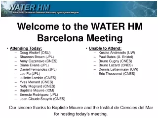
Welcome to the WATER HM Barcelona Meeting • Attending Today: • Doug Alsdorf (OSU) • Shannon Brown (JPL) • Anny Cazenave (CNES) • Diane Evans (JPL) • Daniel Fernandez (JPL) • Lee Fu (JPL) • Juliette Lambin (CNES) • Yves Menard (CNES) • Nelly Mognard (CNES) • Baptiste Mourre (ICM) • Ernesto Rodriguez (JPL) • Jean-Claude Souyris (CNES) • Unable to Attend: • Kostas Andreadis (UW) • Paul Bates (U. Bristol) • Bruno Cugny (CNES) • Bruno Lazard (CNES) • Dennis Lettenmaier (UW) • Eric Thouvenot (CNES) Our sincere thanks to Baptiste Mourre and the Institut de Ciencies del Mar for hosting today’s meeting.
Today’s AgendaWe are not formal today, and strongly encourage dialogue, the exchange of ideas, etc. We will take a coffee-break. • 2:00 – 2:15: Introduction to ICM; meeting agenda: Nelly Mognard, Baptiste Mourre • 2:15 – 2:30: Action Items: Doug Alsdorf • 2:30 – 3:30: Science Questions: Hydrology: Doug Alsdorf, Nelly Mognard Oceanography: Anny Cazenave, Lee Fu • 3:30 – 5:30: Technology Trade-Off Studies: Yves Menard, Ernesto Rodriguez Brief ~5+ minute presentations on recent WATER HM related studies: Hydrology virtual mission: Doug Alsdorf Hydrology data assimilation: Doug Alsdorf Ka-band radar from bridges: Ernesto Rodriguez Radiometer over coasts and land: Shannon Brown (?) CNES Studies: Jean-Claude Souyris • 5:30 – 6:30: International Joint-Science Working Group: Lee Fu, Yves Menard • 6:30 – 7:00: Action Items: Doug Alsdorf Also, a brief discussion on responses SWG should have to Geneva November hydrology meeting; to GEOSS; to others
Key Points for Today’s Discussions • Define the science for WATER HM: • The overall science agenda for WATER HM includes physical oceanography and hydrology. Specific science questions tied with the technology studies need to be finalized. Potential other science targets should be identified here today, but only those that avoid science and technology creep. • Prioritize the trade-off studies: • Trade-off studies are needed that show costs associated with required height accuracies, power, and roll stability. The orbit selection plays a key role in this process. We need to carefully prioritize and coordinate these studies being conducted at CNES and JPL. • Data Processing, Applications, and Synergies • Science and trade-off studies are of an immediate concern, but in the near future we will need to determine how data will be processed and its processing level; who are the potential end users and what are their requirements; and synergies that should be developed with other satellite missions or in-situ sampling groups. • Action Items: • These are focused on the international joint-science working group. Doug Alsdorf, Nelly Mognard
Action Items • The science and trade-off studies which are the bulk of today’s discussions are the core goal of the international joint-science working group (SWG), i.e., to conduct a mission definition study leading to an optimal preliminary design of the mission given science requirements and technology and cost constraints. Thus, our action items are designed to specifically address the formation of the SWG. • Define the International Joint-Science Working Group • The SWG will (1) form the science and applications drivers, (2) derive the accuracies required, and (3) develop the engineering constraints. • Determine SWG Participants and Workers • We need to identify a small number of people with a focused set of hydrological, oceanographic, and technological skills to become SWG participants. We need to make certain that a small team is available to conduct the actual work. We also need to identify how the SWG will contact and involve key international agencies such as Brazil’s ANA (hydrologic gauging group). • Plan First Full SWG Meeting • A goal of the first SWG meeting is to demonstrate that WATER HM is capable of accomplishing the science goals. We need a meeting location, time, agenda, action items, and actions expected to result from the first SWG meeting. Doug Alsdorf
Science Questions • A key aspect of the SWG is to ensure that the global community of oceanographers and hydrologists recognize the importance of bringing together our two communities. The two communities need to ensure that our science goals can be answered by the spatial and temporal resolutions and the height and slope accuracies of the KaRIN instrument. • Connecting science and technology: A goal of the SWG studies should be a prioritization of the science drivers in terms of “critical and must have” (e.g., determination of storage changes in lakes and reservoirs) to those of less importance but still valuable (e.g., land surface topography). This prioritization should focus the mission and prohibit science and technology creep. • Hydrology: Doug Alsdorf, Nelly Mognard • WATER HM will measure the spatial and temporal variability of S and Q. Science questions addressed by these measurements include the global water cycle, flooding hazards, water availability, and changes in these by global warming. Measurements required are h, dh/dx, dh/dt, and water surface area • Oceanography: Anny Cazenave, Lee Fu • WATER HM will measure the spatial and temporal variability of ocean surface topography. Science questions addressed by these measurements include the energy dissipation, ocean circulation, and climate implications from oceanic eddies which contain 90% of the kinetic energy, but are ~10 km scale in cross-stream direction, e.g. Gulf Stream, Kuroshio. Measurements requires are h, dh/dx, dh/dt, over broad areas. • Possible Additional Science: Everyone • Ocean bathymetry, near-shore currents, low-relief land surface topography, sea-ice free board, others? Doug A., Anny C., Lee F., Nelly M.
Hydrology Questions Runoff (mm/day) OBS • Our knowledge of the spatial and temporal distribution of surface waters is poor because: • Unconfined hydraulics of wetlands • Lakes and reservoirs are globally distributed but not measured • Under-developed economic and political infrastructures • Hydrologic Science and Applications Issues: • Need to constrain water and energy cycle models with surface water discharge and storage changes, globally & consistently • Improve understanding of flow hydraulics, especially for flood hazards • Trans-boundary water flows are poorly known but critical for water resource management Models Jan Jul Dec Ohio R. Doug Alsdorf, Nelly Mognard
Oceanography Questions • Conventional Altimetry • Despite a few altimeters operating simultaneously, 200 to 300 km gaps prevent sampling • Along track resolution is much greater than across track • Coastal zones essentially not measured • Oceanography and Applications Issues • Ocean currents contain 90% of kinetic energy, but are ~10 km scale in cross-stream direction, e.g. Gulf Stream, Kuroshio • What are the energy dissipation, ocean circulation, and climate implications? • Upwelling at coasts and cross-shelf transport are <10km scales • Implications on marine life, ecosystems, waste disposal, transportation • Hurricanes have complex spatial structure • Multiple altimeters allow 21% improvement in Hurricane Ivan 96 hour lead time forecast • Denser sampling required for forecasts • Ocean bathymetry can be mapped from slopes in the ocean water surface topography T/P Jason 100 km h ~ 5 cm v ~ 50 cm/s < 10 km T. Strub Anny Cazenave, Lee Fu
Suggested Prioritization of Science Questions • Hydrology: (1 = top priority) • 1: What is the surface water contribution in the terrestrial water cycle? • Requires: global space and time distributions of storage changes and discharges. • 2: What are the potential impacts of flooding events? • Requires: multi-temporal, high-spatial resolution elevation mappings and inundation extents • 3: How are water resources managed across international boundaries? • Requires: storage changes and discharges of key reservoirs and trans-boundary rivers. • 4: What are the potential global impacts of carbon evasion? • Requires: inundation and flow hydraulics from key wetlands and floodplains • 5: Can health issues related to water borne diseases be predicted through better mappings? • Requires: regular mappings of seasonal water bodies, particularly water level changes with time • Oceanography: • 1: How much energy is dissipated through oceanic eddies and what are the impacts on ocean circulation and climate? • Requires: global space and time measurements of OST • 2: What are the rates of upwelling and cross-shelf transport along coastal regions? • Requires: high spatial resolution samplings of OST along coasts • 3: What is the rate of sea-level rise? • Requires: Precise OST heights • 4: What is the improvement in lead-time forecasts of hurricane paths? • Requires: samplings of OST during hurricane season • 5: Can life along coasts, e.g., waste disposal, transportation, be improved through high resolution ocean mappings? • Requires: high spatial resolution samplings of OST along coasts Doug A., Anny C., Lee F., Nelly M.
Suggested Prioritization of Science Questions • Must avoid science and technology creep, but also be open and welcoming of partnerships with other communities, especially those that strengthen WATER HM. • Possible Additional Science: • 1: What is the the bathymetry of the world’s oceans? • Requires: OST slopes at 1-km spatial resolution • 2: What is the topography of the world’s low relief areas, particularly floodplains and coastal zones? • Requires: high-spatial resolution and high accuracy elevation mappings • 3: What is the rate of sea-ice change? • Requires: multi-temporal sea-ice freeboard measurements • 4: Others? Doug A., Anny C., Lee F., Nelly M.
Technology Trade-Off Studies • Trade-off studies are needed that show costs associated with required height accuracies, power, and roll stability. The orbit selection plays a key role in this process. We need to carefully prioritize and coordinate these studies being conducted at CNES and JPL. • CNES developed initial studies necessary for submitting the WatER proposal to ESA whereas JPL has a large investment in WSOA related studies. The SWG needs to update these previous studies by ensuring that the hydrology and oceanographic science drivers are within a reasonable budget (i.e., develop cost trade-offs). • Studies in Progress: • Data assimilation to determine river discharge; assessments of SRTM for estimating discharge: Doug Alsdorf • A hydrology virtual mission study is now fully funded by NASA and will provide trade-offs between various sampling strategies and the derived discharge and storage changes: Doug Alsdorf • Field experiments showing Ka-band radar returns from rivers: Ernesto Rodriguez • Radiometer studies over coasts and land: Shannon Brown • Various CNES studies: Jean-Claude Souyris • Needed Studies: • The costs of orbit selection: • Orbits costs are both technological and scientific: • Various studies have been discussed such as a need to update the CNES WatER power consumption study which focused on sun-synchronous orbits with stationary solar panels instead of a non-sun-synchronous orbit with solar panels rotating once per orbit (or other configurations). Such studies need to recognize that the oceanographic community at the Hobart OST meeting endorsed non-sun-synchronous orbits. Nevertheless, knowing the science, engineering, and cost trade-offs associated with a sun-synchronous vs. non-sun-synchronous orbit are useful for carefully defining the mission. • Using DEMs to mitigate spacecraft roll errors • Using DEMs to correct errors from atmospheric water vapor • Determining the power necessary to meet the require height accuracies • The degree to which rain rates are mitigated, i.e., Ku vs Ka band • Height accuracy over small rivers and problems associated with layover Yves Menard, Ernesto Rodriguez
Technology and Science Coordinated Studies • Hydrology: Key Points needing coordinated study: • Required spatial accuracies are less than 100 m, but what are the cost drivers and technology trade-offs with smaller spatial resolutions? What are the primary and secondary technology cost drivers? • Vertical accuracy is on the order of centimetric, but what are the cost drivers and technology trade-offs with small height accuracies? What are the primary and secondary technology cost drivers? Are costs substantially reduced with lower power requirements? • Temporal sampling is not constrained by terrestrial waters, but orbits do need to extend to 75N and 55S. Ideally we would have about weekly measurements, with slightly more often sampling in the Arctic. What are the cost drivers associated with orbits that provide this coverage? • Oceanography: Key points needing coordinated study: • Tidal aliasing is a key issue that needs a coordinated decision. What are the required height accuracies and spatial resolutions that can be met with a non-sun-synchronous orbit and platform? • Possible Additional Science: • What are the technology and cost drivers associated with ocean bathymetry, near-shore currents, low-relief land surface topography, sea-ice free board, others? These should essentially be available “for free”. • Example: sea-ice extends further north than potential WATER HM orbits, what is the cost of extending the orbital coverage? Yves Menard, Ernesto Rodriguez
International Joint-Science Working Group • Goal of SWG: to conduct a mission definition study leading to an optimal preliminary design of the mission given science requirements and technology and cost constraints. • Build upon success of past altimetry mission collaborations with CNES, NASA, and JPL • What are the technology studies, the science studies, and the combined technology-science studies? • What is the priority ordering of these studies? • Who is conducting the work? • Are funds in-hand, available, or need to be found? Lee Fu, Yves Menard
Action Items • Define the International Joint-Science Working Group • What are the studies to be conducted now? Which are for the future? • Determine SWG Participants and Workers • Who is doing the work? Who is guiding the work? • Plan First Full SWG Meeting • Do we have a meeting location, time, agenda, action items, and expected meeting results? Doug Alsdorf