Download
1 / 43
430 likes | 592 Views
Safety Priority Index System (SPIS). Doug Bish Traffic Services Engineer Oregon Department of Transportation douglas.w.bish@odot.state.or.us. Identify and rank sites most likely to benefit from crash reduction countermeasures Prioritize safety on roadway system

E N D
Safety Priority Index System (SPIS) Doug Bish Traffic Services Engineer Oregon Department of Transportation douglas.w.bish@odot.state.or.us
Identify and rank sites most likely to benefit from crash reduction countermeasures Prioritize safety on roadway system Make safety a factor in decision making Answer public concerns about road safety Why use SPIS (or something like it)?
Prioritizes decisions using an established, data-driven process. Documents safety spending decisions Sets aside designated funds for safety Receives approval at highest policy setting level Get council or commission to approve and support How a good safety program protects(those using the roadway, agency from litigation, funds from misuse)
If we identify it and don’t fix it, aren’t we in trouble? No, as long as you follow policy set by highest levels “You have limited funds and can’t fix everything” If we don’t know about it, we aren’t liable, right? Wrong, you can be held liable regardless, especially if you should have known or someone informed you (e.g., “the public complained several times about the intersection”) How a good safety program protects –
Safety Priority Index System (SPIS) • About SPIS • “Sliding window” concept • Annual SPIS reports • SPIS formula, scores & rankings • Project Development of New SPIS
Roadway network safety screening method Primary tool used by ODOT since 1986 Looks at linear crash data along Roadway does not add in side street crashes at intersections Annual SPIS Uses: 3 years of crash data 0.10-mile “sliding” window 3 crash measures About SPIS
SPIS is just a model, one way to prioritize Crash histories are subject to random variations, one year will be high, the next low SPIS does not account for RTM* * RTM (regression to mean): Do anything or nothing today at a high crash site and it may look like it improved next year (i.e., natural variation looks like real change). About SPIS
0.10-mile roadway segments or “sliding windows” shifted by 0.01-mile increments Segment A (no crashes) Segment B Segment 2 Segment 3 Segment 4 Segment 5 Segment 6 Segment 7 Segment 9 Segment 8 Segment 1 A C B Main Street 5.50 5.55 5.60 5.65 5.70 5.75 5.80 5.85 5.90 5.95 6.00 A = Injury A Crash B = Injury B Crash C = Injury C Crash = Fatal Crash = Property Damage Only Crash SPIS Segment “Sliding Window” • 0.10-mile “window” segment slides 0.01-mile & recalculates SPIS score for each qualified segment • Single crash location captured in multiple SPIS segments • SPIS score calculated & reported for each qualified segment
SPIS Segment “Sliding Window” • The 0.10-mile “window” segments is a misnomer (in a sense). • A segment that is 0.09 in length (from begin to end) contains ten 0.01 mileposts. • Now to further confuse you -- the segment is actually a 10th of a mile in length (or is it?) Segment from 5.55 to 5.64 has 10 points and is 0.09 long 1 2 3 4 5 6 7 8 9 10 5.50 5.55 5.60 5.64 5.65 Hint: The segment contains a half a hundredth on both side of the begin and end mileposts
Public roadway segments with SPIS scores and percentile ranking Sites with highest scores may not be the most likely to benefit from crash reduction measures Investigate SPIS sites to determine if appropriate for crash reduction measures Not all top SPIS sites have cost effective fixes Identify sites with best benefit-to-cost ratio ODOT uses for basis of FHWA 5 Percent Report Annual SPIS Reports
SPIS formula combines crash frequency, rate and severity Overcomes weakness of any one indicator SPIS score only calculated for “qualified” annual SPIS segments 1 fatal or 3 other crashes of any severity in 3 calendar years within same 0.10-mile segment ADT captured by SPIS process SPIS Formula, Score & Rankings
SPIS score = Frequency + Rate + Severity Based on most recent 3 full calendar years of crash data Crash Frequency (25%) 150 crashes in 0.10 mile produces maximum score of 25 Crash Rate (25%) 7 crashes per mvm produces maximum score of 25 Crash Severity Ranking (50%) Fatal and Injury A crashes 100 points each Injury B and C crashes 10 points each PDO crashes 1 point each 300 points produces maximum score of 50 SPIS Formula, Score & Rankings
SPIS Score Calculation Examples Top 5% SPIS Example Top 15% SPIS Example (historically about 54) (historically about 37) • Frequency reaches score of 20 at about 50 crashes & maximum score of 25 at 150 crashes • Rate depends on ADT and reaches maximum score of 25 at rate of 7 crashes per mvm • Severity reaches maximum score of 50 with 3 F&A or 2 F&A and 10 B&C • Microsoft Excel SPIS score calculator available
SPIS Score Percentile Rankings • Top 10% Cutoff SPIS Score • 90% of SPIS segments fall below this score • Determined using on-state highway SPIS data only • Same cutoff score applies to on-state & off-state SPIS rankings • Example • 41,700 on-state highway SPIS segments • SPIS 10% segment = #4,170 (41,700 x 10%); its SPIS score = 42.38 • Top 10% cutoff SPIS score = 42.38 • All SPIS segments with SPIS score > 42.38 in top 10% • ODOT investigates top 5% to identify SPIS segments to include in FHWA 5 Percent Report
Project Development • Requirement of SAFETEA-LU • Each state have the ability to analyze the top 5% of all public roads • Scope • Add City and County Roads • Develop an Adjustable SPIS • Reduce Annual Maintenance • Enhance Crash Summary
Project Development • Initiated in fall of 2008 • First 6 months in discovery mode • Looking at off the shelf products, GIS and data warehouses • Next year piloting a GIS proof of concept • Included five months attempting to get traffic volumes on the local road layer • By August of 2010 the SPIS Architecture was complete • Architecture review and requirements by February 2011 • SPIS ETL (Extract, Translate and Load) complete September 2011 for partial data and February 2012 for a full load • Discovered data gaps in GIS linework • Report development was concurrent to ETL. • SPIS went to production on March 27th 2012
Project Development • Scope stayed very steady • Had to remove ability for OASIS to save queries and have logon ID’s • Removed Map requirements from project to products made outside of SPIS • Proof of Concept was required to flesh out the requirements for a GIS SPIS • System requirements had to be reworked when it was realized that the SPIS data model was inadequate • Requirements for a history report was dropped when it was discovered that the new process would make it very difficult to replicate.
Project Development Moral of the Story • We worked hard to stay within scope, not adding things • We had to remove several non-critical parts • It was much harder than we were led to believe • We encountered several problems with data • Data that looks good at a macro level (i.e., a map) reveals problems when it has to work at the micro level (i.e., 1/100th of a mile)
GIS SPIS • Sources of data • Data processing • GIS layers • Reporting • Data Difficulties/Improvements/Results
Annual SPIS Reports by Score HCDS Annual SPIS Reports by Location ORTRANS GIS FUNCTIONAL CLASS TRANS-INFO On-state highway inventory, feature & location data GIS SPIS The GIS SPIS uses data from several data sources and loads into GIS Off-state roadway location data Bridge features County boundaries City boundaries Signed routes ZIP codes Crash data ADT data GIS PROCESS To SQL Database Excel Spreadsheet with Annual SPIS Data OASIS Tool
GIS SPIS • The data is compiled on a GIS layer • A SPIS Linear Referencing system is created • The collection of data is analyzed • Segments are determined and crashes assigned • Data is loaded from GIS to a conventional SQL database
SPIS LRS Milepoints ODOT Location Milepoints P P P P Site of fatal crash Site of Injury A crash Site of Injury B crash Site of Injury C crash 4.993267 P Site of Property Damage Only crash 5.002534 5.011802 5.021070 5.030338 5.039976 5.099977 5.109682 5.119793 5.129903 5.140013 5.08 5.09 5.150124 5.160234 5.10 5.11 5.12 5.13 5.14 5.15 5.16 5.17 5.18 5.19 5.20 A F A B C F C B C A GIS SPIS In order to support all public roads, the GIS SPIS produces a common reference system in GIS, a SPIS LRS and then translates back to the local LRS (on-state use milepoints, off-state use reference points)
GIS SPIS - Reporting • Reports of the data can be generated from the SQL database • Top 10% by location • Top 10% by score • All Sites by location • All sites by score • Investigation Report • Excel All Sites by location (detailed report)
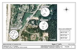
Annual SPIS Reports (off-state) KEY: Road name Begin point reference location Distance and direction from reference location to segment begin point (North is 0 degrees) Direction from segment begin point to end point City (if within city limits) Intersection within segment Average daily traffic Crash counts by type Percentile ranking for segment Annual SPIS score for segment
North (0 degrees) 205 feet/91 degrees Annual SPIS Reports (off-state) KEY: Road name Begin point reference location Distance and direction from reference location to segment begin point (North is 0 degrees) Direction from segment begin point to end point Intersection within segment 95 degrees Medford SPIS segment begin point SPIS segment end point Excel Spreadsheets also have lat and long, use http://www.findlatitudeandlongitude.com/
GIS SPIS – Data Difficulties • When Road numbers or names change • When Jurisdictions change • Recent jurisdiction or name changes impact data, the road may not have the crashes from all three years • Data sources are from different years • Process dependent annual data completion from several sources • Mileposting (state highways) • Although more accurate, segment milepoint begin and end are inconsistent (i.e., appear to be less than 0.10)
GIS SPIS – Crash Data Difficulties • Oregon is primarily a citizen reporting state, only about 6 states do not have the requirement for a police report. • Studies from other states have shown crashes with greater severity are reported with greater reliability than crashes of lower severity. • It is suspected that almost 50% of reportable PDO crashes go unreported when one or more drivers agree not to report. • Crashes may also be non-reportable when: • Do not meet reporting thresholds. • Hit and run with a parked vehicle or property. • Involve multiple vehicles who do not report and no enforcement present. • Does not involve a motor vehicle, i.e. bike vs. pedestrian or pedestrian vs. train. • Ruled the injury cause was a medical illness. • Intentional homicide or suicide. • Crash occurs on private property or not on traffic way (i.e., beach). • Was an industrial accident, i.e., backing over worker with equipment.
GIS SPIS - Improvements • Z mileage and other inconsistencies (primarily on State Highways) are handled correctly • Length of SPIS segments exact • Crashes are located more accurately • Rdwy 1 and 2 are combined more accurately
GIS SPIS – Results for 2012 • 4655 Top 10% On-State sites • 2111 Top 10% Off-State sites • Off-state represents 30% of the total Top 10% sites • The counties with the highest number of Top 10 sites: • Multnomah 854 • Washington 252 • Marion 228 • Clackamas 216 • Lane 134 • The rest had below 100 Top 10% sites each… } (80% of Multnomah County miles is City of Portland) 4 counties make up 75%
Oregon Adjustable Safety Index System • About OASIS • OASIS data • General Settings • Crash Conditions • Equations
OASIS • OASIS is capable of performing the SPIS reports • Users may select only specific crash types or conditions • Users can vary- • Formula defaults • Injury Severity • Segment length • Number of years
OASIS • OASIS uses the data from SPIS data load process • OASIS has State Highway Ramps and connections also (not in Annual SPIS) • Data is compiled in a GIS and then loaded to the SPIS database at the same time Annual SPIS is processed • Data is compiled for different segment lengths to speed the query process
OASIS General Settings • Crash Years: 3 or 5 years • Segment Length: 0.10, 0.20, 0.50, 1.0, 2.0 or 5.0 miles • Segment Qualifier: • 1 crash • 2 crashes • 3 crashes • 1 fatal or 3 crashes • 1 fatal or 1 Injury A or 3 crashes • Jurisdiction: • On-state • Any ODOT region or all state highways • Off-state • 1, 2, or 3 Counties
OASIS – Crash Conditions • Collision Type • Weather Condition • Light Condition • Road Surface Condition • Special Conditions
OASIS – Equations • Four Score Equations • Three from SPIS and a fourth (new) • Adjustments for • Severity (F, A, B, C, and PDO) • Weights • Maximum Values
OASIS Demo of OASIS https://sahara.odot.state.or.us/tad/oasisapp/index.htm
Other • Crash Summary Reports • Things to work on • Rolling Out SPIS • Available Resources
Crash Summary Report • State Highways Only>>>> CSR - Report Manager
Things to come or still work on • Mapping (top 10% or top 15%) • May be static maps • May be GIS tool for queries and maps • Crosswalk table/report for Crash Id’s to SPIS segments • Talk to Transportation Development about additional tools for analysis in GIS
Rolling out the new GIS SPIS • Soft Roll out the first year • Start with a small amount of cities and counties in 2012 • Make available to any agency in 2013 • A city or county can participate with ODOT in submitting Top 5% reports • Just submit investigations of top 5% prior to September 1 of each year. http://safety.fhwa.dot.gov/hsip/fivepercent/
Available Resources • SPIS reports and OASIS online • ODOT Traffic-Roadway Section (TRS) SPIS website • http://www.oregon.gov/ODOT/HWY/TRAFFIC-ROADWAY/spis.shtml • Documentation for new GIS SPIS • http://www.oregon.gov/ODOT/HWY/TRAFFIC-ROADWAY/gis_spis_documentation.shtml • FHWA 5 Percent Report website • http://safety.fhwa.dot.gov/hsip/fivepercent/
Questions? Doug Bish Traffic Services Engineer Oregon Department of Transportation douglas.w.bish@odot.state.or.us