Download

1 / 52
520 likes | 723 Views
Plate Tectonics Horizontal Movement of Earth’s Lithosphere. Plate Tectonics The Theory of Plate Tectonics Plate Boundaries Spreading Centers Subduction Zones Transform Faults Plate Movement. The Theory of Plate Tectonics. “Continental Drift” - theory* proposed by

E N D
Plate Tectonics Horizontal Movement of Earth’s Lithosphere
Plate Tectonics • The Theory of Plate Tectonics • Plate Boundaries • Spreading Centers • Subduction Zones • Transform Faults • Plate Movement
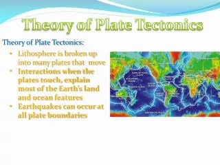
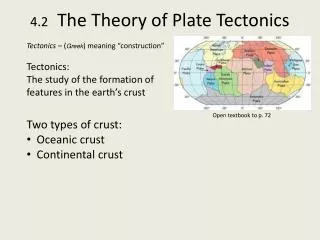
The Theory of Plate Tectonics “Continental Drift” - theory* proposed by Alfred Wagner, a German meteorologist (1915) • Explained by: • geologic fit • fossils * Not accepted by scientific community - no mechanism to explain plate movement
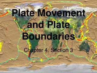
The Theory of Plate Tectonics(cont’d.) • Plate Tectonics- evidence for theory of continental driftHess, Heezen and Tharp (1960’s) • found lithospheres plate boundaries, 3 types: • ridges (spreading centers) • trenches (subduction zones) • transform faults (plates sliding past one another)
The Theory of Plate Tectonics(cont’d.) Lithospheric Plates • minor plates: • Cocos - 5 x10⁶ km2 • Phillipine - 6 x10⁶ km2 • Caribbean - 5 x10⁶ km2 • Nazca - 15 x106 km2 • Arabian - 8 x10⁶ km2 • Indian - 10 x106 km2 • Scotia - 5 x10⁶ km2 • Juan de Fuca - 2 x10⁶ km2 • major plates: • Pacific – 105 x106 km2 • Eurasian - 70 x106 km2 • Antarctic - 60 x106 km2 • Australian - 45 x106 km2 • S. American - 45 x106 km2 • African - 80 x106 km2 • N. American - 60 x106 km2 From Fundamentals of Oceanography, 5h edition, Duxbury Duxbury, and Sverdup. The McGraw-Hill Companies
Plate Boundaries a) Spreading centers - ‘rift zones’(cont’d.) • Convection cells form • Density differences – cool vs. hot • Convection cells cause frictional drag on lithosphere • Lithosphere stretches due to convective movement • Lithospheric crust weakens
Plate Boundaries(cont’d.) a) Spreading centers - ‘rift zones’(cont’d.) • Faulting – break in overlying lithosphere • Magma flows upward • New lithospheric crust formed
Plate Boundaries(cont’d.) a) Spreading centers - ‘rift zones’(cont’d.) • Plates split apart -‘divergent plate’ boundary • New crust formed - ‘constructive’ plate boundary • Evolution of a mid-ocean ridge system • Upwarping • Rift valley • Linear sea • Mid-ocean ridge system • Ex. 1 - oceans: mid Atlantic Ridge • east Pacific Rise • Ex. 2 - continents: E. Africa Rift Valley Baikal Rift Valley
Plate Boundaries(cont’d.) b)Subduction zones • Lithospheric Plates collide - ‘convergent’ plate boundary • Crust destroyed - ‘destructive’ plate boundary • Forms trenches and mountains
Plate Boundaries(cont’d.) b)Subduction zones(cont’d.) • 3 types of subduction zones: • Ocean crust into continental crust – form trenches and • mountain ranges Ex. a): Juan de Fuca plate into the N. American plate - forms Cascade Mtn. Range Ex. b): Nazca plate into the S. American plate - forms Peru-Chile Trench and the Andes Mtn. Range
Plate Boundaries(cont’d.) b)Subduction zones(cont’d.) • Ocean crust into ocean crust – forms trenches and island arcs • Ex. A): Philippine plate into the Pacific plate – formed the Marianna Trench • and the Marianna Island Arc system • Ex. B): N. American plate into the Caribbean plate and then the N. American • plate into the S. American plate – formed the Isthmus of Panama
Plate Boundaries(cont’d.) b)Subduction zones(cont’d.) • Continental crust into continental crust – form mountain ranges • Ex. A): Indian plate into the Eurasian plate – formed the Himalayas • Ex. B): Eurasian plate into the African plate - closing up of the • Mediterranean sea
Plate Boundaries(cont’d.) c) Transform faults • Plates slide past one another • Lithospheric crust neither created nor destroyed - ‘conservative’ plate boundary Ex. A) Pacific plate sliding past N. American plate – forms the San Andreas Fault
Plate Movement • New crust is created at spreading centers at a rate of approximately • 1-10cm per year • Old crust is destroyed at the same rate at subduction zones • How do we know these rates? (Rate=distance/time)
Plate Movement (cont’d.) • Magnetic anomalies in ocean crust...look at spreading centers • paleomagnetism • every so often Earth’s magnetic field flips (every 300K-500K years) • magnetic signal recorded in crust at spreading center as it’s formed, forms bands of crust with either a weak or strong magnetic signal • determine rate of plate movement by distance of band from spreading center divided by age of rock in band (r=d/t)
Plate Movement (cont’d.) • Hot spots • Emperor Sea Mount chain • islands or sea mountains formed over hotspots (fixed area where magma comes up) • lithosphere moves over hotspot and end up have volcanic mountain over hotspot as well as a series of mountains in ‘front’ of hotspot • determine rate of plate movement by distance of mountain from hotspot divided by age of rock in mountain (r=d/t)
Learning Objectives Understand the processes that are continuously changing Earth’s surface as lithospheric plates move relative to one another. Identify the role of oceanic ridges, transform faults and deep-sea trenches in defining the edges of lithospheric plates. Understand the importance of asthenospheric thermal convection in plate tectonics and the resulting compression or tensional forces at the plate boundaries. Explain the distribution of magnetic anomaly stripes, seismicity, and volcanism in terms of the concept of global plate tectonics. Calculate spreading rates of ocean basins.
Age of Ocean Crust http://www.ngdc.noaa.gov/mgg/geology/geology.html
Oceanic crust moves away from MOR (Mid Oceanic Ridge) and cools and subsides
3-3 Constructive margins Midocean ridges Destructive margins Subduction zones Driving Mechanisms for Plate Motions
Type of boundary between plates: Constructive margins Mid ocean ridges Destructive margins Subduction zones Conservative margins Transform faults
Conservative margins Transform faults
Conservative margins Transform faults The San Andreas fault in southern California
3-3 • Mantle plumes originate deep within the asthenosphere as molten rock which rises and melts through the lithospheric plate forming a large volcanic mass at a “hot spot”. Mantle Plume
Geological Periods Precambrian 4.6 B - 570 Ma solidification Cambrian 514 Ma Gondwana, hard shell anim. Ordovician 458 Ma separation, coldest Silurian 425 Ma Laurentia collides with Baltica Devonian 390 Ma pre-Pangea, equatorial forests Early Carboniferous 356 Ma Late Carboniferous 306 Ma western Pangea is complete Permian 255 Ma deserts, reptiles, major ext. Triassic 237 Ma Life begins to rediversify,Pangea Jurassic 195 Ma Dinosaurs, Pangea starts to break Late Jurassic 152 Ma Pangea rifts apart, Atlantic Cretaceous 94 Ma New oceans, India K/T extinction 66 Ma end of dinosaurs Eocene 50.2 Ma India collides with Asia Miocene 14 Ma Modern look Modern Future World +50 Ma N. Atlantic widens, Med. vanish Future +100 Ma new subduction Future +250 Ma new Pangea
Precambrian break-up of the supercontinent, Rodinia, which formed 1100 million years ago. The Late Precambrian was an "Ice House" World, much like the present-day. Source: www.scotese.com CambrianAnimals with hard-shells appeared in great numbers for the first time during the Cambrian. The continents were flooded by shallow seas. The supercontinent of Gondwana had just formed and was located near the South Pole.
Ordovician During the Ordovician ancient oceans separated the barren continents of Laurentia, Baltica, Siberia and Gondwana. The end of the Ordovician was one of the coldest times in Earth history. Ice covered much of the southern region of Gondwana. SilurianLaurentia collides with Baltica closing the northen branch of the Iapetus Ocean and forming the "Old Red Sandstone" continent. Coral reefs expand and land plants begin to colonize the barren continents.
Devonian By the Devonian the early Paleozoic oceans were closing, forming a "pre-Pangea". Freshwater fish were able to migrate from the southern hemisphere continents to North America and Europe. Forests grew for the first time in the equatorial regions of Artic Canada. Early CarboniferousDuring the Early Carboniferous the Paleozoic oceans between Euramerica and Gondwana began to close, forming the Appalachian and Variscan mountains. An ice cap grew at the South Pole as four-legged vertebrates evolved in the coal swamps near the Equator.
Late Carboniferous By the Late Carboniferous the continents that make up modern North America and Europe had collided with the southern continents of Gondwana to form the western half of Pangea. Ice covered much of the southern hemisphere and vast coal swamps formed along the equator. PermianVast deserts covered western Pangea during the Permian as reptiles spread across the face of the supercontinent.
Triassic The supercontinent of Pangea, mostly assembled by the Triassic, allowed land animals to migrate from the South Pole to the North Pole; and warm-water faunas spread across Tethys. The first mammals and dinosaurs appeared; JurassicBy the Early Jurassic, south-central Asia had assembled. A wide Tethys ocean separated the northern continents from Gondwana. Subduction zone Rocky Mountains
Formation of the Rocky Mountains http://wrgis.wr.usgs.gov/docs/parks/province/rockymtn.html
Late JurassicIn the Late Jurassic the Central Atlantic Ocean was a narrow ocean separating Africa from eastern North America. Cretaceous During the Cretaceous the South Atlantic Ocean opened. India separated from Madagascar and raced northward on a collision course with Eurasia. Notice that North America was connected to Europe, and that Australia was still joined to Antarctica.
K/T extinctionThe bull's eye marks the location of impact site of a 10 mile wide comet caused global climate changes that killed the dinosaurs and many other forms of life. By the Late Cretaceous the oceans had widened, and India approached the southern margin of Asia. Eocene 50 - 55 million years ago India began to collide with Asia forming the Tibetan plateau and Himalayas (destroying the last of Tethys ocean). Australia, which was attached to Antarctica, began to move rapidly northward.
3-2 • Whereas oceanic ridges indicate tension, continental mountains indicate compressional forces are squeezing the land together. Sedimentary Rocks Squeezed by Compression
Miocene20 million years ago, Antarctica was covered by ice and the northern continents were cooling rapidly. The world has taken on a "modern" look, but notice that Florida and parts of Asia were flooded by the sea. Arabia moved away from Africa forming Gulf of Aden and Red Sea; Last Ice Age When the Earth is in its "Ice House" climate mode, there is ice at the poles. The polar ice sheet expands and contacts because of variations in the Earth's orbit (Milankovitch cycles). The last expansion of the polar ice sheets took place about 18,000 years ago.
Modern World If we continue present-day plate motions the Atlantic will widen, Africa will collide with Europe closing the Mediterranean, Australia will collide with S.E. Asia, and California will slide northward up the coast to Alaska.
Future +100 Earth is ~ 4.6 bill years old – suggested cyclic of 500 mill year pattern of assembling and disassembling the land masses; Future +250
The Wilson Cycleuses plate tectonic processes to show development and creation of ocean floor and ocean basins;