Download

1 / 57
570 likes | 634 Views
Implementing ecosystem-based Integrated Resource Management Plan to reconcile traditional way-of-life, forestry, and hunting/fishing, ensuring sustainability. The plan fosters co-management, cultural preservation, and revenue sharing. Phases include data collection, IRMP preparation, and implementation recommendations. Guiding principles focus on conservation and versatile use. Programs focus on indigenous knowledge, sustainable development, and economic/social aspects. Mapping sacred areas, wildlife habitats, and sensitive zones are integral parts of the plan.

E N D
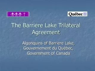
The Barriere Lake Trilateral Agreement Algonquins of Barriere Lake, Gouvernement du Québec, Government of Canada
MITCHIKANIBIKOK INIK Trilateral Agreement Territory: Location Trilateral Agreement Territory La Verendrye Wildlife Reserve Boundary Rapid Lake Community Quebec
MITCHIKANIBIKOK INIK Agreement Objectives • To develop for implementation, a draft ecosystem-based Integrated Resource Management Plan (IRMP) with a commitment to the principles of sustainable development, conservation, protection of the traditional way of life of the Algonquins, & versatile resource use. • To reconcile forestry operations and sports hunting and fishing with the environmental concerns & traditional way-of-life of the Algonquins of Barriere Lake.
practical ‘sustainable development’ Basis for co-management and resource revenue sharing arrangements with government blends traditional ways with modern development processes common working environment for regional stakeholders documents cultural & ecological aspects of aboriginal way-of-life creates educational & operational model Identifies cultural and environmental candidate protected areas MITCHIKANIBIKOK INIK Significance as Pilot Project
MITCHIKANIBIKOK INIK Phases of the Trilateral Agreement • Phase I: the collection, inventory, study and analysis of data respecting renewable resources & their uses on the territory • Phase II: preparation of a draft IRMP • Phase III: formulation of recommendations regarding draft IRMP implementation
MITCHIKANIBIKOK INIK Guiding Principles • continuation of the traditional way-of-life • conservation • versatile use • adaptive ecosystem-based management
Phase I Activities • Indigenous Knowledge Program • Natural Resources & Sustainable Development Program • Economic/Social Development Program • Measures to Harmonize Forestry Activities with the traditional activities of the Algonquins
MITCHIKANIBIKOK INIK Logical Framework
MITCHIKANIBIKOK INIK Indigenous Knowledge Program • To document Algonquin ecological & social knowledge for incorporation into the IRMP, & thereby facilitate harmonization of Algonquin & non-Algonquin land-use regimes consistent with the interest of the Algonquins of Barriere Lake.
MITCHIKANIBIKOK INIK SAS Mapping LEGEND Sacred Areas Sugar Bush Occupancy Roots Burial Sites Wood Moose Yards Tobacco Spawning Areas Medicinal Plants
MITCHIKANIBIKOK INIK LEGEND Toponym Site Hydrography Roads Algonquin Toponymy
MITCHIKANIBIKOK INIK Big Game Kills LEGEND Bear Deer Moose
Areas of Concern Management Strategy ABL Areas of Concern (SAS) Algonquin traditional occupancy and use sites documented during Phase I - Strategies & Prescriptions developed by IRMP Technical Team in consultation with ABL for Phase II IRMP planning. Ministry of Natural Resources, Wildlife and Parks Guidelines & Land Affectation Quebec Forest Act
MITCHIKANIBIKOK INIK Provisional Measures • Sensitive Area Study (SAS); identification of sensitive zones to be protected within cutting areas • Measures to Harmonize (MTH) forestry operations with the Algonquin way-of-life
MITCHIKANIBIKOK INIK Measures to Harmonize LEGEND Harvest Zone Harvest Exclusion Zone Requiring Measures to Harmonize Hydrography Ecoforestry Polygon Planned Roads
MITCHIKANIBIKOK INIK Sustainable Development of Natural Resources • To obtain & utilize the highest quality forestry & wildlife data in the development of a sustainable adaptive management strategy for the renewable resources of the Trilateral Agreement Territory (TAT).
MITCHIKANIBIKOK INIK 20-40 years 40-60 years 60-80 years 80-100 years 100+ years Young Old Modeling Forest Growth PRESENT AGE CLASS LEGEND FUTURE AGE CLASS
MITCHIKANIBIKOK INIK High Suitability Medium Suitability Low Suitability Null Suitability SUMMER Habitat Suitability: Moose HABITAT CLASSIFICATION LATE WINTER EARLY WINTER
MITCHIKANIBIKOK INIK Economic/Social Development Program • To profile & analyze Algonquin & non-Algonquin local & regional socio-economic activities & the legal frameworks which govern them, facilitating the selection of sustainable resource management alternatives consistent with the interests of the Algonquins of Barriere Lake.
MITCHIKANIBIKOK INIK Context: Forestry in the TAT • TAT area: 10,900 km2 • No. Common Areas (CAAFs): 7 • Area occupied by CAAFs: 9,188 km2 • No. CAAF beneficiaries: 36 • Gross merchantable volume (all species): 77,025,340 m3 • AAC (all species): 1,289,687 m3
MITCHIKANIBIKOK INIK Economic Value of Activities in the TAT(1994 Data)
Phase II Activities • Conservation Suitability Gap Analysis • Preparation of Wildlife Management Plans • Preparation of Draft Integrated Resource Management Plans for 7 Traditional Management Areas (TMA’s)
Conservation Suitability Analysis • Collaboration between World Wildlife Fund - Canada & ABL (Arbex Forest Resource Consultants) • Natural Regions C2, C3, & C6 Data layers • Forest cover diversity • Old growth forest • Road less/intact areas • Enduring features • Physical habitat diversity • Cutover areas
Preliminary Findings - Areas within the Trilateral Agreement Territory could be considered as “candidate protection areas” for regional representation of enduring natural features. • A correlation exists between high value candidate protection areas and sites identified as culturally significant by the Algonquins.
Integrated Resource Management Planning Strategies • Diverse planning team involving ABL • Planned public input through standard public consultation for CAAF holders & ABL community meetings • Planned public inspection of final plan as a component of the Trilateral Agreement Process • Algonquin values mapping & updates of maps 2000-2003 • Area of concern planning process
MITCHIKANIBIKOK INIK Planning Issues, Influences and Concerns • Algonquin issues, aspirations & concerns • current forest condition • desired future forest condition • non-timber values requiring protection • existing resource uses of the territory • other resource management issues • current legislation & government policy issues
Benchmark Scenarios 1) Unrestricted Harvest (All Eligible Harvest Area is available for harvest) 2) Quebec Forest Act Applied 3) Quebec Forest Act & TAT Area of Concern Strategies Applied 4) Quebec Forest Act & Enhanced TAT Area of Concern Strategies Applied 5) Conservation Suitability Analysis Areas (Top 12% and 8% CSA Areas removed from EHA) * Scenarios were not developed for uneven-age management regimes as uneven-age strategies are viewed as less intrusive by the ABL.
Scenario 5 – TMA 2 NW SectionConservation Suitability Analysis
Scenario Modeling / Negotiation Support • In cooperation with Quebec our planning team is developing a computer model to predict future wood supply under various management scenarios. This model will assist and support negotiations for the implementation of the IRMP by predicting the future forest condition expected to result from the implementation of each strategy and test each strategy for its ability to ensure forest sustainability while ensuring the continuance of the Algonquin traditional activities over time.
MITCHIKANIBIKOK INIK Measuring Social Criteria and Indicators • To know if ecosystems are being managed in a sustainably and in a culturally appropriate manner - parameters linked to sustainability of ecosystems and culture must be measured. • Basis for continuous improvement of forest management from ABL perspective
Social Indicators - Process • Development of Social Indicators is a dynamic process which will evolve with needs and new knowledge • Trend data, fixed measures, indices and ratios may be used • Principles will be refined and validated over time through monitoring, data collection and analysis • Require inputs of time and money
Examples of Social Indicators • Area of Land & Quality of Resources for Subsistence & Cultural Purposes • Level of Land Alienation • Algonquin Values Documents & Maps used in decision making process • Protection of cultural & heritage sites • Level of Societael & Economic Benefit
Examples of Social Indicators (cont.) • Distribution of resource benefits & revenues • Level of Land Use Conflict • Level of Community Satisfaction with IRMP process • Participation of ABL in decision making process • ABL & Scientific Databases etc.
Examples of Measures • Level of transmigration of Algonquin harvesters within and between TMAs • Geographic distribution of harvests (percent area) within TMA • Level of traditional Land Use and practise of traditional activities • Level of satisfaction with hunting, trapping, fishing results • Prescence/absence of ABL land use maps